Category:Montsec
Jump to navigation
Jump to search
| Object location | | View all coordinates using: OpenStreetMap |
|---|
mountain  | |||||
| Upload media | |||||
| Instance of |
| ||||
|---|---|---|---|---|---|
| Made from material | |||||
| Location | |||||
| Has part(s) | |||||
| IUCN protected areas category | |||||
| Inception |
| ||||
| Length |
| ||||
| Mountain range | |||||
| Highest point |
| ||||
| Area |
| ||||
| Elevation above sea level |
| ||||
 | |||||
Català: Serra del Montsec serra dels prepirineus catalans
|
This is a category with photos about a natural area in Catalonia, Spain, with id: ES510192
|
Subcategories
This category has the following 4 subcategories, out of 4 total.
M
S
- Serra de Montclús (1 F)
Media in category "Montsec"
The following 15 files are in this category, out of 15 total.
-
 Banner for the Conca de Tremp-Montsec Global Geopark in Tremp.jpg 4,160 × 3,120; 7.55 MB
-
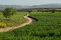 Bellmunt drylands, Lleida.jpg 3,456 × 2,304; 5.04 MB
-
 Griffon Vulture, Gyps fulvus, in flight.jpg 1,748 × 1,292; 854 KB
-
 Lammergeier or Bearded Vulture, Gypaetus barbatus. In flight.jpg 1,416 × 1,100; 423 KB
-
 Maçana, Camarasa, vistes del pantà. (27210410851).jpg 5,169 × 3,768; 5.24 MB
-
 Muralla China de Finestras.jpg 5,975 × 2,924; 12.15 MB
-
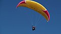 Paragliding in Catalonia.jpg 2,304 × 1,296; 695 KB
-
 Poppy field in Montsec.jpg 1,984 × 1,272; 2.41 MB
-
 Serra del Montsec - 1.jpg 3,600 × 2,246; 3.36 MB
-
 Serra del Montsec, Camarasa, Spain (Unsplash).jpg 4,096 × 2,730; 2.01 MB
-
 Serra montsec.JPG 4,000 × 2,248; 3.92 MB
-
 Thekla Lark, Galerida theklae.jpg 1,536 × 1,268; 823 KB
-
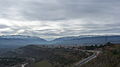
 Vista de la conca de Tremp camí del Montsec.jpeg 1,556 × 720; 120 KB
-
 Vistes cap al Montsec.jpg 1,632 × 3,264; 1.38 MB
-
 Vol en globus - 2007 - 07.JPG 2,048 × 1,536; 1.21 MB


.jpg)


.jpg)


