Category:Rivers of Arizona
Vai alla navigazione
Vai alla ricerca
Stati degli USA: Alabama · Alaska · Arizona · Arkansas · California · Carolina del Nord · Carolina del Sud · Colorado · Connecticut · Dakota del Nord · Dakota del Sud · Delaware · Florida · Georgia · Hawaii · Idaho · Illinois · Indiana · Iowa · Kansas · Kentucky · Louisiana · Maine · Maryland · Massachusetts · Michigan · Minnesota · Mississippi · Missouri · Montana · Nebraska · Nevada · New Hampshire · New Jersey · New York · Nuovo Messico · Ohio · Oklahoma · Oregon · Pennsylvania · Rhode Island · Tennessee · Texas · Utah · Vermont · Virginia · Virginia Occidentale · Washington · Wisconsin · Wyoming – Washington
Guam · Porto Rico
Guam · Porto Rico
lista di un progetto Wikimedia | |||||
| Carica un file multimediale | |||||
| Istanza di | |||||
|---|---|---|---|---|---|
| |||||
Sottocategorie
Questa categoria contiene le 44 sottocategorie indicate di seguito, su un totale di 44.
'
- Riparian forests in Arizona (2 F)
*
+
.
A
- Arivaca Creek (4 F)
B
C
- Cañada del Oro (12 F)
- Chevelon Creek (8 F)
D
- Diamond Creek (Arizona) (3 F)
G
H
K
- Kingman Wash, Lake Mead (6 F)
L
N
- New River (Arizona) (1 F)
P
R
S
T
V
W
File nella categoria "Rivers of Arizona"
Questa categoria contiene 36 file, indicati di seguito, su un totale di 36.
-
-

-

-
 Babocomari River Arizona 2014.jpeg 1 069 × 1 427; 535 KB
-
 Big Sandy River - US93 - Wikieup, Arizona.jpg 2 400 × 3 600; 3,76 MB
-
 Black River East Fork in the White Mountains (5849786784).jpg 4 444 × 4 135; 10,26 MB
-
 BlackRiver01.jpg 331 × 223; 28 KB
-
 By the River - Flickr - romainguy.jpg 5 767 × 3 604; 7,06 MB
-
 Chinle Wash.jpg 2 272 × 1 704; 918 KB
-
 Elk in East Verde River.jpg 1 152 × 2 048; 558 KB
-
 Final, Arizona statewide wild and scenic rivers legislative environmental impact statement (IA finalarizonastat5282unit).pdf 1 202 × 1 606, 724 pagine; 142,81 MB
-
 Hoover-dam-site.jpg 700 × 524; 295 KB
-
 Horseshoe Bend AZ.jpg 3 264 × 2 448; 2,04 MB
-
 Horseshoe Reservoir on Verde River.jpg 4 608 × 3 456; 3,74 MB
-
 John K. Hillers - East Fork, de Chelly River, Arizona - 2010.213 - Cleveland Museum of Art.tif 4 725 × 5 919; 80,03 MB
-
 Kanab canyon.jpg 365 × 550; 64 KB
-
 Map of the Navajo Volcanic Fields.jpg 1 280 × 1 467; 568 KB
-
 Puerco River in Petrified Forest NP.jpg 4 288 × 2 848; 9,32 MB
-
 Rock Formations, Oak Creek Canyon, AZ 7-30-13l (9509429455).jpg 1 648 × 1 750; 1,03 MB
-
 Rock Formations, Oak Creek Canyon, AZ 7-30-13m (9512219078).jpg 1 750 × 1 254; 847 KB
-
 Rock Spires, Oak Creek Canyon, AZ 7-30-13h (9509422807).jpg 1 478 × 1 750; 1,03 MB
-
 Rock Spires, Oak Creek Canyon, AZ 7-30-13i (9509421509).jpg 1 313 × 1 750; 772 KB
-
 Rock Spires, Oak Creek Canyon, AZ 7-30-13l (9509419637).jpg 1 459 × 1 750; 974 KB
-
 Rock Spires, Oak Creek Canyon, AZ 7-30-13n (9509418493).jpg 1 547 × 1 750; 945 KB
-
 Rock Wall, Oak Creek Canyon, AZ 7-30-13c (9512207118).jpg 1 750 × 1 293; 744 KB
-
 Rock Wall, Oak Creek Canyon, AZ 7-30-13g (9509413889).jpg 1 152 × 1 750; 810 KB
-
 Rock Wall, Oak Creek Canyon, AZ 7-30-13h (9512203628).jpg 1 750 × 1 334; 1,03 MB
-
 Rock Wall, Oak Creek Canyon, AZ 7-30-13m (9509410715).jpg 1 750 × 1 378; 862 KB
-
 Rock Wall, Oak Creek Canyon, AZ 7-30-13p (9512226344).jpg 1 750 × 1 183; 919 KB
-
 Rye Creek and Tonto Creek.jpg 1 512 × 2 181; 1 MB
-
 San Simon River and Gold Gulch.jpg 1 650 × 2 455; 6,28 MB
-
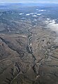
 San Simon River from the air.jpg 2 252 × 2 182; 9,76 MB
-
 Vermillion Cliffs NM (9404230745).jpg 5 616 × 3 744; 9,37 MB
-
 Wpdms nasa topo outline virgin river.jpg 300 × 260; 41 KB
-
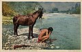
 Colorado river(?), by Continent Stereoscopic Company.jpg 2 737 × 1 712; 1,71 MB
-
 Colorado river(?), by Continent Stereoscopic Company.png 2 737 × 1 712; 5,77 MB
.jpg)
.jpg)
.jpg)


.jpg)


.jpg)
.jpg)
.jpg)
.jpg)
.jpg)
.jpg)
.jpg)
.jpg)
.jpg)
.jpg)
.jpg)


.jpg)

,_by_Continent_Stereoscopic_Company.jpg)
,_by_Continent_Stereoscopic_Company.png)