Category:SVG locator maps of Bouvet Island (location map scheme)
Jump to navigation
Jump to search

|
SVG maps in this category are part of a locator map series applying the (de) widespread location map scheme. Please see root category to browse for more. |
.svg)
.svg)
.svg)
.svg)
.svg)
.svg)
.svg)
Locator maps design recommendations ▼ | |
|---|---|
Principles
Design Guidelines are based on ▸location map design of the German map shop (in German). It's preferable to derive new locator maps from existing location maps. Please keep both size and ratio in this case. Thus the new locator maps may still be applied as location map (▸Guide). Marker color is supposed to be darkred. Waterbodies may be transparent, to show other objects better. Please be aware that this guide is only a recommendation. It’s not an inevitable law!
Highlight small areas
“Remote” areas and mini maps
Mini maps show where the depicted area actually is situated. Check out ▸Vorlage:Positionskarte+ (in German) and ▸Modèle:Carte en coin (in French) of how to insert a mini map in virtually every map.
Disputed areas
Greyed special objects
Backgrounds
|

-en.svg)

.svg)
.svg)
.svg)

_(US48).svg)
_(small_islands_magnified)_(-mini_map_-rivers).svg)
.svg)
_(extra_close)_(US48).svg)
.svg)
_(zoom).svg)

.svg)


_(UNMIK).svg)
.svg)
_(disputed_hatched).svg)
_(claimed_and_disputed_hatched).svg)
.svg)
.svg)
_(%2Ball_claims_hatched).svg)

.svg)
_(shade).svg)
_(shade)_(special_marker).svg)
_(-mini_map).svg)
_(-mini_map).svg)
_(-mini_map).svg)


.svg)

.svg)
Media in category "SVG locator maps of Bouvet Island (location map scheme)"
The following 15 files are in this category, out of 15 total.
-
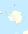 Bouvet Island in Antarctica (extended).svg 1,614 × 1,992; 1.01 MB
-

-
 Bouvet Island in its region (+Norwegian Antarctic claims hatched).svg 1,151 × 648; 6.92 MB
-
 Bouvet Island in its region (+Norwegian Antarctic claims) (wo south border).svg 1,151 × 648; 6.92 MB
-
 Bouvet Island in its region (+Norwegian Antarctic claims).svg 1,151 × 648; 6.92 MB
-
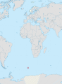
 Bouvet Island in its region.svg 1,151 × 648; 6.92 MB
-
 Bouvet Island in Norway (no south border).svg 4,657 × 6,353; 7.4 MB
-
 Bouvet Island in Norway.svg 4,657 × 6,353; 7.4 MB
-
 Bouvet Island on globe (Antarctica centered).svg 512 × 663; 515 KB
-
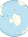
 Bouvet Island on the globe (Antarctica centered).svg 798 × 798; 1.36 MB
-

-
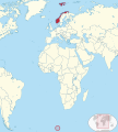
 Norway in its region (+Antarctic claims hatched) (Bouvet Island special).svg 1,377 × 1,847; 6.98 MB
-
 Norway in its region (+Antarctic claims) (Bouvet Island special) (wo south border).svg 1,377 × 1,847; 6.98 MB
-
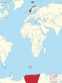 Norway in its region (+Antarctic claims) (Bouvet Island special).svg 1,377 × 1,847; 6.98 MB
-
 Norway in its region (Bouvet Island special).svg 1,377 × 1,535; 6.98 MB
.svg)
_(wo_south_border).svg)
.svg)
_(wo_south_border).svg)
.svg)

.svg)

.svg)
.svg)
_(Bouvet_Island_special)_(wo_south_border).svg)
_(Bouvet_Island_special).svg)
_(Bouvet_Island_special)_(wo_south_border).svg)
_(Bouvet_Island_special).svg)
.svg)