Category:SVG locator maps of provinces of Armenia (location map scheme)
Jump to navigation
Jump to search

|
SVG maps in this category are part of a locator map series applying the (de) widespread location map scheme. Please see root category to browse for more. |
.svg)
.svg)
.svg)
.svg)
.svg)
.svg)
.svg)
Locator maps design recommendations ▼ | |
|---|---|
Principles
Design Guidelines are based on ▸location map design of the German map shop (in German). It's preferable to derive new locator maps from existing location maps. Please keep both size and ratio in this case. Thus the new locator maps may still be applied as location map (▸Guide). Marker color is supposed to be darkred. Waterbodies may be transparent, to show other objects better. Please be aware that this guide is only a recommendation. It’s not an inevitable law!
Highlight small areas
“Remote” areas and mini maps
Mini maps show where the depicted area actually is situated. Check out ▸Vorlage:Positionskarte+ (in German) and ▸Modèle:Carte en coin (in French) of how to insert a mini map in virtually every map.
Disputed areas
Greyed special objects
Backgrounds
|

-en.svg)

.svg)
.svg)
.svg)

_(US48).svg)
_(small_islands_magnified)_(-mini_map_-rivers).svg)
.svg)
_(extra_close)_(US48).svg)
.svg)
_(zoom).svg)

.svg)


_(UNMIK).svg)
.svg)
_(disputed_hatched).svg)
_(claimed_and_disputed_hatched).svg)
.svg)
.svg)
_(%2Ball_claims_hatched).svg)

.svg)
_(shade).svg)
_(shade)_(special_marker).svg)
_(-mini_map).svg)
_(-mini_map).svg)
_(-mini_map).svg)


.svg)

.svg)
Media in category "SVG locator maps of provinces of Armenia (location map scheme)"
The following 21 files are in this category, out of 21 total.
-
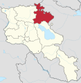
 Aragatsotn in Armenia.svg 1,169 × 1,198; 415 KB
-
 Ararat in Armenia (de-facto hatched).svg 1,169 × 1,198; 422 KB
-
 Ararat in Armenia (de-facto).svg 1,169 × 1,198; 418 KB
-
 Ararat in Armenia.svg 1,169 × 1,198; 415 KB
-
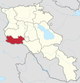 Armavir in Armenia.svg 1,169 × 1,198; 415 KB
-
 Artsvashen in Armenia.svg 1,169 × 1,198; 422 KB
-
 Barkhudarli in Armenia.svg 1,169 × 1,198; 422 KB
-
 Gegharkunik in Armenia (de-facto).svg 1,169 × 1,198; 420 KB
-
 Gegharkunik in Armenia (non-controlled hatched).svg 1,169 × 1,198; 419 KB
-
 Gegharkunik in Armenia.svg 1,169 × 1,198; 415 KB
-
 Karki in Armenia.svg 1,169 × 1,198; 420 KB
-
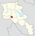
 Kotayk in Armenia.svg 1,169 × 1,198; 415 KB
-
 Lori in Armenia.svg 1,169 × 1,198; 415 KB
-
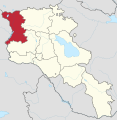 Shirak in Armenia.svg 1,169 × 1,198; 415 KB
-
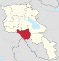
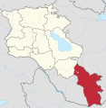 Syunik in Armenia.svg 1,169 × 1,198; 415 KB
-
 Tavush in Armenia (de-facto hatched).svg 1,169 × 1,198; 421 KB
-
 Tavush in Armenia (de-facto).svg 1,169 × 1,198; 418 KB
-
 Tavush in Armenia.svg 1,169 × 1,198; 415 KB
-
 Vayots Dzor in Armenia.svg 1,169 × 1,198; 415 KB
-
 Yerevan in Armenia.svg 1,169 × 1,198; 415 KB
-
 Yukhari in Armenia.svg 1,169 × 1,198; 422 KB

.svg)
.svg)


.svg)
.svg)


.svg)
.svg)


