Category:Safed
Jump to navigation
Jump to search
city in northern Israel  Un barri de Safed, el 2006  | |||||
| Upload media | |||||
| Instance of | |||||
|---|---|---|---|---|---|
| Location | Safed Subdistrict, Northern District, Israel | ||||
| Located in or next to body of water |
| ||||
| Population |
| ||||
| Area |
| ||||
| Elevation above sea level |
| ||||
| official website | |||||
 | |||||
Subcategories
This category has the following 28 subcategories, out of 28 total.
A
- Aerial photographs of Safed (19 F)
- Akbara Rock (36 F)
- Safed in art (9 F)
B
- Beit Castel (5 F)
- Blue Valley, Safed (10 F)
C
- Coats of arms of Safed (4 F)
E
G
H
M
N
- Night in Safed (42 F)
O
P
S
T
- Tomb of Nachum Ish Gamzu (4 F)
V
- Views of Mount Meron from Safed (16 F)
Z
- Safed zoo (4 F)
Pages in category "Safed"
The following 3 pages are in this category, out of 3 total.
Media in category "Safed"
The following 200 files are in this category, out of 684 total.
(previous page) (next page)-
 10082012a 015.jpg 2,592 × 1,944; 1.23 MB
-
 10082012a 017.jpg 1,944 × 2,592; 717 KB
-
 10082012a 019.jpg 2,592 × 1,944; 1.21 MB
-
 10082012a 024.jpg 2,361 × 1,559; 594 KB
-
-

-

-

-
-

-

-

-

-

-

-
-
-

-

-

-

-

-
-

-

-

-

-

-

-
-
-
-

-
-

-

-

-
-

-
 20200213 133153 Safed Central Bus Station.jpg 4,608 × 2,592; 4.29 MB
-
 20200213 134136 2020 in Safed.jpg 4,608 × 2,592; 4.56 MB
-
 20200213 134738 Safed.jpg 2,592 × 4,608; 3.47 MB
-
 20200213 151846 2020 in Safed.jpg 4,608 × 2,592; 4.27 MB
-
 49426 street in safed PikiWiki Israel.jpg 3,277 × 2,024; 1.31 MB
-
 88243 safed center livnot ulehibanot PikiWiki Israel.jpg 3,648 × 2,056; 2.26 MB
-
 88244 safed center livnot ulehibanot PikiWiki Israel.jpg 2,056 × 3,648; 2 MB
-
 88245 safed center livnot ulehibanot PikiWiki Israel.jpg 2,056 × 3,648; 1.82 MB
-
 88247 safed center livnot ulehibanot PikiWiki Israel.jpg 2,056 × 3,648; 2.47 MB
-
 PikiWiki Israel 87646 beit abo safed.jpg 2,576 × 1,188; 820 KB
-
 Aged Tzfatit Cheese In a Restaurant in Tzfat Israel.jpg 5,184 × 3,456; 1.9 MB
-
 Alleys down meron - panoramio.jpg 2,816 × 2,112; 2.28 MB
-
 Amirim entance - panoramio.jpg 2,816 × 2,112; 1.31 MB
-
 Arch of ruins off the trails near Akbara - panoramio.jpg 3,680 × 2,760; 2.53 MB
-
 Art in Sefad (8121506242).jpg 5,616 × 3,744; 5.98 MB
-
 Art in Sefad (8121507518).jpg 5,616 × 3,744; 8.88 MB
-
 Artistic quarter - Safed.jpg 3,968 × 2,976; 4.02 MB
-
 Artists Quarter, Safed (3301188377).jpg 2,272 × 1,704; 799 KB
-
 Beit castel gallery courtyard.jpg 1,600 × 1,200; 465 KB
-
 Big rock at the bottom of the waterfall - panoramio.jpg 2,816 × 2,112; 2.51 MB
-
 PikiWiki Israel 60482 the bridge on jerusalem street in safed.jpg 3,543 × 2,362; 4.69 MB
-
 PikiWiki Israel 60483 the bridge on jerusalem street in safed.jpg 3,543 × 2,362; 5.91 MB
-
 Bridge tsfat.jpg 4,128 × 3,096; 7.1 MB
-
 Cave - panoramio (8).jpg 2,816 × 2,112; 1.46 MB
-
 Cave of Shem and Ever, where Jacob (from the bible) studied - panoramio.jpg 3,680 × 2,760; 2.39 MB
-
 Cobblestone streets of rosh pinna - panoramio.jpg 3,680 × 2,760; 2.58 MB
-
 Edible plant seen off the trails near Akbara - panoramio.jpg 3,680 × 2,760; 2.72 MB
-
 Ein Talmon pump station - panoramio.jpg 2,816 × 2,112; 2.07 MB
-
 French fry vending machine1.jpg 1,024 × 1,536; 163 KB
-
 Hacia altos del Golan - panoramio.jpg 843 × 687; 276 KB
-
 Har Shamai at sunset - panoramio.jpg 2,816 × 2,112; 2.05 MB
-
 Haredi in Safed (3302017278).jpg 2,272 × 1,704; 793 KB
-
 Hebrew alphabet by KKL stamps of places in Israel.png 1,199 × 365; 495 KB
-
 Hechsher Safed Rabbinate.jpg 1,009 × 988; 102 KB
-
 IAFFartist.jpg 971 × 1,348; 212 KB
-
 IL-Safed-Meron.jpg 1,402 × 931; 543 KB
-
 IL-Safed-Stadt.jpg 1,402 × 931; 488 KB
-
 Industrial Silo in Tzfat Industrial Zone - panoramio.jpg 2,816 × 2,112; 2.21 MB
-
 Industrial zone of Safed - panoramio.jpg 2,816 × 2,112; 2.14 MB
-
 Industrial zone of safed - panoramio.jpg 2,816 × 2,112; 2.15 MB
-
 Inside the Tunnel under 85 - panoramio.jpg 3,680 × 2,760; 2.79 MB
-
 Israel - Golan Heights - Tsfat - 01 (4264470054).jpg 4,272 × 2,848; 4.38 MB
-
 Israel - Golan Heights - Tsfat - 05 (4264475926).jpg 4,272 × 2,848; 5.07 MB
-
 Israel - Golan Heights - Tsfat - 10 (4263734897).jpg 4,166 × 2,777; 3.92 MB
-
 Israel - Golan Heights - Tsfat - 11 (4264486316).jpg 4,258 × 2,838; 2.86 MB
-
 Israel - Golan Heights - Tsfat - 12 (4264494412).jpg 4,272 × 2,848; 5.8 MB
-
 Israel DSC09043 (9626450935).jpg 3,240 × 4,320; 3.79 MB
-
 Israel DSC09126 (9629918272).jpg 3,240 × 4,320; 4.13 MB
-
 Israel Hiking Map עין גיא אוני 1.jpeg 1,600 × 1,200; 1.13 MB
-
 Israel Hiking Map עין גיא אוני.jpeg 1,600 × 1,200; 1.11 MB
-
 Israel Hiking Map עין כובס.jpeg 1,600 × 1,200; 686 KB
-
 Kiryat hamanim-Safed.jpg 4,000 × 3,000; 1.06 MB
-
 Learning in Tzvas.JPG 1,984 × 1,488; 701 KB
-
 Letter of Samuel ben Israel Peretz Heller, Safed 1834.jpg 533 × 737; 217 KB
-
 Little hill next to Safed - panoramio (3).jpg 2,816 × 2,112; 2.2 MB
-
 Zafed manhole cover.jpg 3,456 × 4,608; 6.56 MB
-
 Safed manhole cover.jpg 1,500 × 2,000; 727 KB
-
 Marketplace in Safed.jpg 1,984 × 2,331; 628 KB
-
 Not so busy streets in Tzfat - panoramio.jpg 1,600 × 1,200; 524 KB
-
 Obsolete Technology Near Akbara cliffs - panoramio.jpg 3,680 × 2,760; 2.72 MB
-
 Obsolete technology Near Akbara cliffs - panoramio.jpg 3,680 × 2,760; 2.73 MB
-
 Panorama Safed and Mount Meron.jpg 15,898 × 3,421; 4.91 MB
-
 Panorama Safed צפת (Sea of Galilee in the background).jpg 3,321 × 743; 479 KB
-
 PikiWiki Israel 10660 edge of the view.jpg 1,600 × 1,200; 349 KB
-
 PikiWiki Israel 10682 beautiful zfat.JPG 3,648 × 2,736; 289 KB
-
 PikiWiki Israel 10684 beautiful zfat.JPG 3,648 × 2,736; 381 KB
-
 PikiWiki Israel 11153 view of zfat.JPG 1,920 × 2,560; 335 KB
-
 PikiWiki Israel 11154 view of zfat.JPG 2,560 × 1,920; 674 KB
-
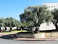 PikiWiki Israel 11219 Ancient olive trees.JPG 4,320 × 3,240; 2.37 MB
-
 PikiWiki Israel 11221 Snow in the mountains of Safed.jpg 1,600 × 1,200; 1.31 MB
-
 PikiWiki Israel 11222 Sunset in the mountains of Safed.JPG 1,024 × 768; 77 KB
-
 PikiWiki Israel 11223 Sunset in the mountains of Safed.JPG 1,024 × 768; 82 KB
-
 PikiWiki Israel 11224 Meron Mountains landscape.jpg 1,600 × 1,200; 817 KB
-
 PikiWiki Israel 11430 View the Safed.JPG 1,200 × 900; 1,006 KB
-
 PikiWiki Israel 11432 Bare tree.JPG 1,500 × 1,125; 1.87 MB
-
 PikiWiki Israel 11433 View the Safed.JPG 1,500 × 2,000; 2.59 MB
-
 PikiWiki Israel 16913 a zimmer in zefat.jpg 2,876 × 1,924; 2.22 MB
-
 PikiWiki Israel 21635 Old City of Safed.jpg 533 × 800; 291 KB
-
 PikiWiki Israel 32722 Geography of Israel.JPG 2,000 × 1,500; 972 KB
-
 PikiWiki Israel 32723 Geography of Israel.JPG 2,000 × 1,500; 742 KB
-
 PikiWiki Israel 32724 Geography of Israel.JPG 2,000 × 1,500; 964 KB
-
 PikiWiki Israel 32726 Geography of Israel.JPG 2,000 × 1,500; 999 KB
-
 PikiWiki Israel 32727 Geography of Israel.JPG 2,000 × 1,500; 970 KB
-
 PikiWiki Israel 32728 Geography of Israel.JPG 2,000 × 1,500; 1.15 MB
-
 PikiWiki Israel 32729 Geography of Israel.JPG 2,000 × 1,500; 1.18 MB
-
 PikiWiki Israel 32731 Geography of Israel.JPG 2,000 × 1,500; 1.09 MB
-
 PikiWiki Israel 32733 Geography of Israel.JPG 2,000 × 1,500; 440 KB
-
 PikiWiki Israel 32740 Geography of Israel.JPG 2,000 × 1,500; 731 KB
-
 PikiWiki Israel 32744 Geography of Israel.JPG 2,000 × 1,500; 531 KB
-
 PikiWiki Israel 35276 safed side.jpg 960 × 720; 57 KB
-
 PikiWiki Israel 36781 Architechture and Texture.JPG 2,304 × 3,456; 2.32 MB
-
 PikiWiki Israel 36782 Architechture and Texture.JPG 2,304 × 3,456; 2.36 MB
-
 PikiWiki Israel 38513 Scenic Safed.jpg 4,928 × 3,264; 1.48 MB
-
 PikiWiki Israel 38625 Architechture and Texture.jpg 500 × 753; 292 KB
-
 PikiWiki Israel 38822 IDF.jpg 678 × 480; 55 KB
-
 PikiWiki Israel 38886 Safed.JPG 3,872 × 2,592; 3.85 MB
-
 PikiWiki Israel 38887 Safed.JPG 3,872 × 2,592; 4.13 MB
-
 PikiWiki Israel 39457 Art of Israel.JPG 5,616 × 3,744; 4.79 MB
-
 PikiWiki Israel 39459 Art of Israel.JPG 5,616 × 3,744; 4.67 MB
-
 PikiWiki Israel 39460 Geography of Israel.JPG 5,616 × 3,744; 3.87 MB
-
 PikiWiki Israel 39468 Geography of Israel.JPG 3,872 × 2,592; 3.18 MB
-
 PikiWiki Israel 39469 Geography of Israel.JPG 3,872 × 2,592; 4.08 MB
-
 PikiWiki Israel 39470 Cities in Israel.JPG 3,872 × 2,592; 3.58 MB
-
 PikiWiki Israel 39472 Geography of Israel.JPG 3,872 × 2,592; 3.69 MB
-
 PikiWiki Israel 39473 Art of Israel.JPG 3,872 × 2,592; 3.78 MB
-
 PikiWiki Israel 39475 Art of Israel.JPG 5,616 × 3,744; 4.92 MB
-
 PikiWiki Israel 39490 Geography of Israel.JPG 3,872 × 2,592; 3.16 MB
-
 PikiWiki Israel 39491 Geography of Israel.JPG 3,872 × 2,592; 3.92 MB
-
 PikiWiki Israel 39492 Geography of Israel.JPG 3,872 × 2,592; 3.98 MB
-
 PikiWiki Israel 39493 Geography of Israel.JPG 3,872 × 2,592; 4.38 MB
-
 PikiWiki Israel 39494 Geography of Israel.JPG 3,872 × 2,592; 2.79 MB
-
 PikiWiki Israel 39496 Geography of Israel.JPG 3,872 × 2,592; 4.31 MB
-
 PikiWiki Israel 39497 Geography of Israel.JPG 3,872 × 2,592; 3.71 MB
-
 PikiWiki Israel 39498 Geography of Israel.JPG 3,872 × 2,592; 3.04 MB
-
 PikiWiki Israel 39499 Geography of Israel.JPG 3,872 × 2,592; 4.37 MB
-
 PikiWiki Israel 39500 Cities in Israel.JPG 3,872 × 2,592; 3.65 MB
-
 PikiWiki Israel 39501 Art of Israel.JPG 3,872 × 2,592; 2.86 MB
-
 PikiWiki Israel 39502 Art of Israel.JPG 3,872 × 2,592; 4.57 MB
-
 PikiWiki Israel 39503 Cities in Israel.JPG 3,872 × 2,592; 2.84 MB
-
 PikiWiki Israel 39504 Cities in Israel.JPG 3,872 × 2,592; 3.36 MB
-
 PikiWiki Israel 39505 Art of Israel.JPG 3,872 × 2,592; 4.53 MB
-
 PikiWiki Israel 39506 Art of Israel.JPG 3,872 × 2,592; 3.97 MB
-
 PikiWiki Israel 39507 Art of Israel.JPG 3,872 × 2,592; 4.39 MB
-
 PikiWiki Israel 39510 Geography of Israel.JPG 3,872 × 2,592; 2.05 MB
-
 PikiWiki Israel 39511 Cities in Israel.JPG 3,872 × 2,592; 4.89 MB
-
 PikiWiki Israel 39512 Geography of Israel.JPG 3,872 × 2,592; 4.87 MB
-
 PikiWiki Israel 39513 Geography of Israel.JPG 3,872 × 2,592; 2.93 MB
-
 PikiWiki Israel 39514 Art of Israel.JPG 3,872 × 2,592; 3.26 MB
-
 PikiWiki Israel 39515 Cities in Israel.JPG 3,872 × 2,592; 3.48 MB
-
 PikiWiki Israel 39518 Cities in Israel.JPG 3,872 × 2,592; 4.46 MB
-
 PikiWiki Israel 39519 Cities in Israel.JPG 3,872 × 2,592; 3.1 MB
-
 PikiWiki Israel 39520 Cities in Israel.JPG 3,872 × 2,592; 3.81 MB
-
 PikiWiki Israel 39521 Geography of Israel.JPG 3,872 × 2,592; 3.96 MB
-
 PikiWiki Israel 39523 Cities in Israel.JPG 3,872 × 2,592; 2.64 MB
-
 PikiWiki Israel 39524 Geography of Israel.JPG 3,872 × 2,592; 3.97 MB
-
 PikiWiki Israel 39527 Cities in Israel.JPG 3,872 × 2,592; 4.09 MB
-
 PikiWiki Israel 39529 Geography of Israel.JPG 3,872 × 2,592; 4.55 MB
-
 PikiWiki Israel 39530 Cities in Israel.JPG 3,872 × 2,592; 3.01 MB
-
 PikiWiki Israel 39538 Art of Israel.JPG 3,872 × 2,592; 4.03 MB
-
 PikiWiki Israel 39539 Art of Israel.JPG 3,872 × 2,592; 3.89 MB
-
 PikiWiki Israel 39541 Art of Israel.JPG 3,872 × 2,592; 3.61 MB
-
 PikiWiki Israel 39542 Cities in Israel.JPG 3,872 × 2,592; 3.6 MB
-
 PikiWiki Israel 39543 Cities in Israel.JPG 3,872 × 2,592; 2.78 MB
-
 PikiWiki Israel 42529 Cities in Israel.jpg 4,160 × 3,120; 5.2 MB
-
 PikiWiki Israel 42531 Cities in Israel.JPG 2,848 × 4,288; 4.18 MB
-
 PikiWiki Israel 42532 Cities in Israel.JPG 3,224 × 2,299; 2.95 MB
-
 PikiWiki Israel 42533 Geography of Israel.JPG 1,847 × 804; 633 KB
-
 PikiWiki Israel 42641 zfat.jpg 2,048 × 1,411; 1.44 MB
-
 PikiWiki Israel 43677 Dragonfly.jpg 960 × 720; 51 KB
-
 PikiWiki Israel 43678 Ants.jpg 4,160 × 3,120; 5.55 MB
-
 PikiWiki Israel 43679 Snake slough.jpg 1,280 × 1,280; 507 KB
-
 PikiWiki Israel 43708 Tzfat citythe artist avaneu Israel.jpg 4,128 × 2,322; 810 KB
-
 PikiWiki Israel 43709 Tzfat city Israel.jpg 4,128 × 2,322; 850 KB
-
 PikiWiki Israel 43710 Tzfat city Israel.jpg 4,128 × 2,322; 960 KB
-
 PikiWiki Israel 43711 Tzfat city Israel.jpg 4,128 × 2,322; 1.37 MB
-
 PikiWiki Israel 43801 TZFAT.JPG 3,456 × 2,304; 3.42 MB
-
 PikiWiki Israel 43802 TZFAT.JPG 3,456 × 2,304; 3.57 MB
-
 PikiWiki Israel 43805 TZFAT.JPG 3,456 × 2,304; 3.6 MB
-
 PikiWiki Israel 43806 TZFAT.JPG 3,456 × 2,304; 4.08 MB
-
 PikiWiki Israel 43808 TZFAT.JPG 3,456 × 2,304; 3.95 MB
-
 PikiWiki Israel 43812 TZFAT.JPG 3,456 × 2,304; 4.06 MB


.jpg)
.jpg)
.jpg)
.jpg)
.jpg)
.jpg)
.jpg)
.jpg)
.jpg)
.jpg)
.jpg)
.jpg)
.jpg)
.jpg)
.jpg)
.jpg)
.jpg)
.jpg)
.jpg)
.jpg)
.jpg)
.jpg)
.jpg)
.jpg)
.jpg)
.jpg)
.jpg)
.jpg)
.jpg)
.jpg)
.jpg)
.jpg)
.jpg)
.jpg)
.jpg)


.jpg)
.jpg)

.jpg)


.jpg)
_studied_-_panoramio.jpg)


.jpg)


.jpg)
.jpg)
.jpg)
.jpg)
.jpg)
.jpg)
.jpg)


.jpg)


.jpg)