Category:Sierra County, California
Zur Navigation springen
Zur Suche springen
Counties of California: Alameda · Alpine · Amador · Butte · Calaveras · Colusa · Contra Costa · Del Norte · El Dorado · Fresno · Glenn · Humboldt · Imperial · Inyo · Kern · Kings · Lake · Lassen · Los Angeles · Madera · Marin · Mariposa · Mendocino · Merced · Modoc · Mono · Monterey · Napa · Nevada · Orange · Placer · Plumas · Riverside · Sacramento · San Benito · San Bernardino · San Diego · San Joaquin · San Luis Obispo · San Mateo · Santa Barbara · Santa Clara · Santa Cruz · Shasta · Sierra · Siskiyou · Solano · Sonoma · Stanislaus ·Sutter · Tehama · Trinity · Tulare · Tuolumne · Ventura · Yolo · Yuba – Consolidated city-county: San Francisco
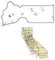
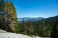
English: Sierra County is located on the eastern side of Northern California. The county is within the northern Sierra Nevada mountain range. Present day Sierra County was the northern reach of the mid-19th century prospecting and mining activity of the California Gold Rush.
County im US-Bundesstaat Kalifornien    | |||||
| Medium hochladen | |||||
| Ist ein(e) | |||||
|---|---|---|---|---|---|
| Benannt nach | |||||
| Ort | Kalifornien, Pacific States Region | ||||
| Hauptstadt | |||||
| Datum der Gründung, Erstellung, Entstehung, Erbauung |
| ||||
| Gebirgszug | |||||
| Einwohnerzahl |
| ||||
| Fläche |
| ||||
| Verschieden von | |||||
| offizielle Website | |||||
 | |||||
Unterkategorien
Es werden 7 von insgesamt 7 Unterkategorien in dieser Kategorie angezeigt:
In Klammern die Anzahl der enthaltenen Kategorien (K), Seiten (S), Dateien (D)
G
H
N
P
T
Seiten in der Kategorie „Sierra County, California“
Diese Kategorie enthält nur die folgende Seite.
Medien in der Kategorie „Sierra County, California“
Folgende 44 Dateien sind in dieser Kategorie, von 44 insgesamt.
-

-

-

-

-
 Barn along the road in Northern California LCCN2013633854.tif 7.360 × 4.912; 206,9 MB
-
 Between Downieville and Sierra City.jpg 3.000 × 4.000; 5,27 MB
-
 California State Route 49 at scenic overlook.jpg 3.000 × 4.000; 4,61 MB
-
 Crystal Peak Mine (Front View).jpg 4.160 × 3.120; 6,23 MB
-
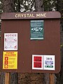 Crystal Peak Mine Sign.jpg 3.120 × 4.160; 5,37 MB
-
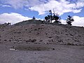
 Crystal Peak Mine.jpg 4.160 × 3.120; 6,1 MB
-
 Dog Valley.jpg 3.872 × 2.592; 4,45 MB
-
 Eat Beef sign along the road in Northern California LCCN2013633844.tif 4.912 × 7.360; 206,9 MB
-
 Elymus trachycaulus subsp. trachycaulus - Flickr - aspidoscelis (2).jpg 3.600 × 2.400; 1,8 MB
-
 Entrance to a farm in Northern California is covered in antlers LCCN2013633853.tif 7.360 × 4.912; 206,9 MB
-
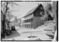
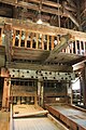
 Exterior of Stamp Mill at Kentucky Mine in Sierra County, CA.JPG 4.752 × 3.168; 5,96 MB
-

-

-

-

-

-
-

-

-
 Monte Cristo Map.png 2.358 × 1.764; 1,95 MB
-
 Pelton Wheel at Kentucky Mine in Sierra County, CA 2.JPG 3.168 × 4.752; 6,45 MB
-
 Pelton Wheel at Kentucky Mine in Sierra County, CA.JPG 4.752 × 3.168; 5,72 MB
-
 Purple at Yuba Pass - panoramio.jpg 4.032 × 3.024; 4,58 MB
-
 Seal of Sierra County, California.png 404 × 410; 141 KB
-

-

-
 Gold-Quartz-70388.jpg 800 × 503; 80 KB
-
-

-
 Sierra County California United States 2023 June 01.jpg 3.024 × 4.032; 4,36 MB
-
 Sierra County California United States 2023 June 02.jpg 3.024 × 4.032; 3,15 MB
-
 Upper little truckee river.jpg 2.736 × 3.648; 2,14 MB
-
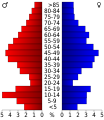 USA Sierra County, California age pyramid.svg 520 × 600; 7 KB
-
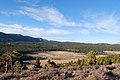
 View from Crystal Peak.jpg 6.000 × 4.000; 20,24 MB
-
 Wooden barn along the road in Northern California LCCN2013633849.tif 7.360 × 4.912; 206,9 MB
-
 Working Stamps in Stamp Mill at Kentucky Mine in Sierra County, CA 2.JPG 3.168 × 4.752; 6,72 MB
-
 Working Stamps in Stamp Mill at Kentucky Mine in Sierra County, CA.JPG 4.752 × 3.168; 6,85 MB
-
 Yuba Pass Sundown - panoramio.jpg 3.024 × 3.024; 2,74 MB
-
 Yuba River 5.jpg 4.000 × 3.000; 4,36 MB
-
 Yuba River 6.jpg 3.000 × 4.000; 5,32 MB


.jpg)


.jpg)


