Category:Utah State Route 9
Jump to navigation
Jump to search
 | number: | (nine) |
|---|---|---|
| State highways in Utah: | 1 · 2 · 3 · 4 · 5 · 6 · 7 · 8 · 9 · 10 · 11 · 12 · 13 · 14 · 15 · 16 · 17 · 18 · 19 · 20 · 21 · 22 · 23 · 24 · 25 · 26 · 27 · 28 · 29 |
Counties of Utah: Kane · Washington ·
state highway in Washington and Kane counties in Utah, United States   | |||||
| Upload media | |||||
| Instance of | |||||
|---|---|---|---|---|---|
| Location |
| ||||
| Located in or next to body of water | |||||
| Transport network | |||||
| Connects with | |||||
| Owned by | |||||
| Maintained by | |||||
| Has part(s) | |||||
| Inception |
| ||||
| Length |
| ||||
| Terminus | |||||
| Replaces | |||||
 | |||||
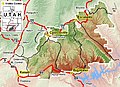
English: Media related to Utah State Route 9, a 57.1124-mile (91.9135 km) state highway located in southwestern Utah, United States that connects Interstate 15 in Washington with U.S. Route 89 at Mount Carmel Junction (in Orderville), passing through Zion National Park. (The eastern half, from the south entrance of Zion National Park, is also known as the Zion-Mount Carmel Highway.) Although Utah State Route 9 runs through Zion National Park, the section within the park is not maintained by the Utah Department of Transportation or the State of Utah. The route was formerly designated as Utah State Route 15 (1912-1977).
Subcategories
This category has the following 6 subcategories, out of 6 total.
*
Media in category "Utah State Route 9"
The following 10 files are in this category, out of 10 total.
-
 GSENM-map.jpg 668 × 483; 108 KB
-
-
-

-

-

-
-
 Utah 9.svg 600 × 600; 11 KB
-
 Utah Route 9 map.png 917 × 624; 52 KB
-
 Utah SR 9.svg 385 × 385; 7 KB

