File:16th century Portuguese Spanish trade routes.png
跳至導覽
跳至搜尋

預覽大小:800 × 335 像素。 其他解析度:320 × 134 像素 | 640 × 268 像素 | 1,024 × 429 像素 | 1,280 × 536 像素 | 2,835 × 1,188 像素。
原始檔案 (2,835 × 1,188 像素,檔案大小:2 MB,MIME 類型:image/png)
說明
說明
添加單行說明來描述出檔案所代表的內容
| 描述 |
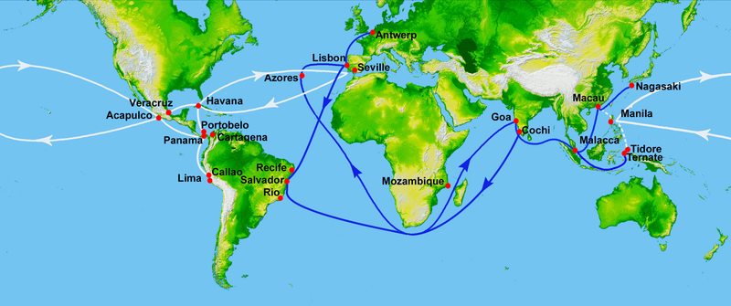
Map showing main Portuguese (blue) and Spanish (white) oceanic trade routes in the 16th century, as a result of the exploration during the Age of Discovery.
|
| 日期 | (UTC) |
| 來源 | |
| 作者 |
|
| 這是一張修飾過的圖片,即本圖片是用軟體修改過後的版本,修改的方式或內容有:depiction of 16th century Portuguese and Spanish trade routes。原版圖片來源:World Topography.jpg。修改者:Uxbona。
|
|
|
 | |
原始上傳日誌
[編輯]
This image is a derivative work of the following images:
- File:World_Topography.jpg licensed with PD-USGov-NASA-SRTM
- 2009-03-17T12:12:25Z Sk 21600x9049 (17145460 Bytes) {{Information |Description=PIA03395: World in Mercator Projection, Shaded Relief and Colored Height |Source=http://photojournal.jpl.nasa.gov/catalog/PIA03395 |Date=February 2000 |Author=NASA/JPL/NIMA |Permission={{PD-USGov-
Uploaded with derivativeFX
檔案歷史
點選日期/時間以檢視該時間的檔案版本。
| 日期/時間 | 縮圖 | 尺寸 | 用戶 | 備註 | |
|---|---|---|---|---|---|
| 目前 | 2023年7月15日 (六) 23:50 | | 2,835 × 1,188(2 MB) | Hohum(對話 | 貢獻) | Brighten |
| 2013年2月17日 (日) 20:21 |  | 2,835 × 1,188(745 KB) | JohnnyMrNinja(對話 | 貢獻) | remove unused alpha, indexed colors and increased compression (reduced size about 3x) | |
| 2012年1月16日 (一) 23:00 |  | 2,835 × 1,188(2.45 MB) | Uxbona(對話 | 貢獻) | restored missing route to Antwerp | |
| 2012年1月16日 (一) 11:00 |  | 2,835 × 1,188(2.45 MB) | Uxbona(對話 | 貢獻) | restored missing outbound route | |
| 2012年1月12日 (四) 19:16 |  | 2,835 × 1,188(2.45 MB) | Uxbona(對話 | 貢獻) | corrected locations and typo (Seville, Salvador, Manila) | |
| 2011年9月4日 (日) 00:06 |  | 3,000 × 1,257(2.66 MB) | Uxbona(對話 | 貢獻) | (Added Callao after comment, and Antwerp - as those are relevant stopovers. Detailed Brazilian Salvador and Pernambuco stopovers.) | |
| 2011年9月4日 (日) 00:02 |  | 11,812 × 4,950(7.84 MB) | Uxbona(對話 | 貢獻) | Reverted to version as of 23:57, 3 September 2011 | |
| 2011年9月4日 (日) 00:02 |  | 5,906 × 2,475(7.52 MB) | Uxbona(對話 | 貢獻) | (Added Callao after comment, and Antwerp - as those are relevant stopovers. Detailed Brazilian Salvador, Pernambuco and Cochi stopovers.) | |
| 2011年9月3日 (六) 23:57 |  | 11,812 × 4,950(7.84 MB) | Uxbona(對話 | 貢獻) | Added Callao after comment, and Antwerp - as those are relevant stopovers. Detailed Brazilian Salvador and Pernambuco stopovers. | |
| 2010年9月7日 (二) 08:13 |  | 2,953 × 1,225(2.4 MB) | Uxbona(對話 | 貢獻) | add Mozambique stopover |
無法覆蓋此檔案。
檔案用途
下列3個頁面有用到此檔案:
全域檔案使用狀況
以下其他 wiki 使用了這個檔案:
- ar.wikipedia.org 的使用狀況
- azb.wikipedia.org 的使用狀況
- ca.wikipedia.org 的使用狀況
- de.wikipedia.org 的使用狀況
- el.wikipedia.org 的使用狀況
- en.wikipedia.org 的使用狀況
- Acapulco
- Colonialism
- Privateer
- New Spain
- Treaty of Tordesillas
- Piracy in the Caribbean
- Conquistador
- Spice trade
- Manila galleon
- Trade route
- Age of Discovery
- Spanish treasure fleet
- Asiento de Negros
- Sea lane
- Filipinos
- Filipino nationalism
- Volta do mar
- List of World Heritage Sites in Mexico
- Marine navigation
- Winds in the Age of Sail
- User:Uxbona
- Iberian ship development, 1400–1600
- Exploration of the Pacific
- User:StAnMc18/sandbox
- Political economy in anthropology
- Global silver trade from the 16th to 19th centuries
- Maritime Silk Road
- Jorge Cabral
- 1557 influenza pandemic
- User:Goatmanatee/Spanish treasure fleet
- User:Goatmanatee/Manila galleon
- Economic history of Latin America
- es.wikipedia.org 的使用狀況
檢視此檔案的更多全域使用狀況。
詮釋資料
分類:
- Maps showing 16th-century history
- Maps of trade routes
- Maps of maritime history
- Maps of the history of colonies of Portugal
- Maps of the Viceroyalty of New Spain
- Manila galleon
- Maps of the Captaincy General of the Philippines
- Age of Discovery
- Asia in the 16th century
- Cuba in the 16th century
- Europe in the 16th century
- Mexico in the 16th century
- Portugal in the 16th century
- South America in the 16th century
- Spain in the 16th century
- Maps of Spanish trade routes
- Iberian ship development, 1400–1600
- Maps of the world with Mercator projection