File:1850 Mitchell Map of Peru and Bolivia - Geographicus - PeruBolivia-mitchell-1850.jpg
Ir a la navegación
Ir a la búsqueda

Tamaño de esta previsualización: 723 × 600 píxeles. Otras resoluciones: 289 × 240 píxeles | 579 × 480 píxeles | 926 × 768 píxeles | 1234 × 1024 píxeles | 2468 × 2048 píxeles | 3500 × 2904 píxeles.
Archivo original (3500 × 2904 píxeles; tamaño de archivo: 3,55 MB; tipo MIME: image/jpeg)
Leyendas
Leyendas
Añade una explicación corta acerca de lo que representa este archivo
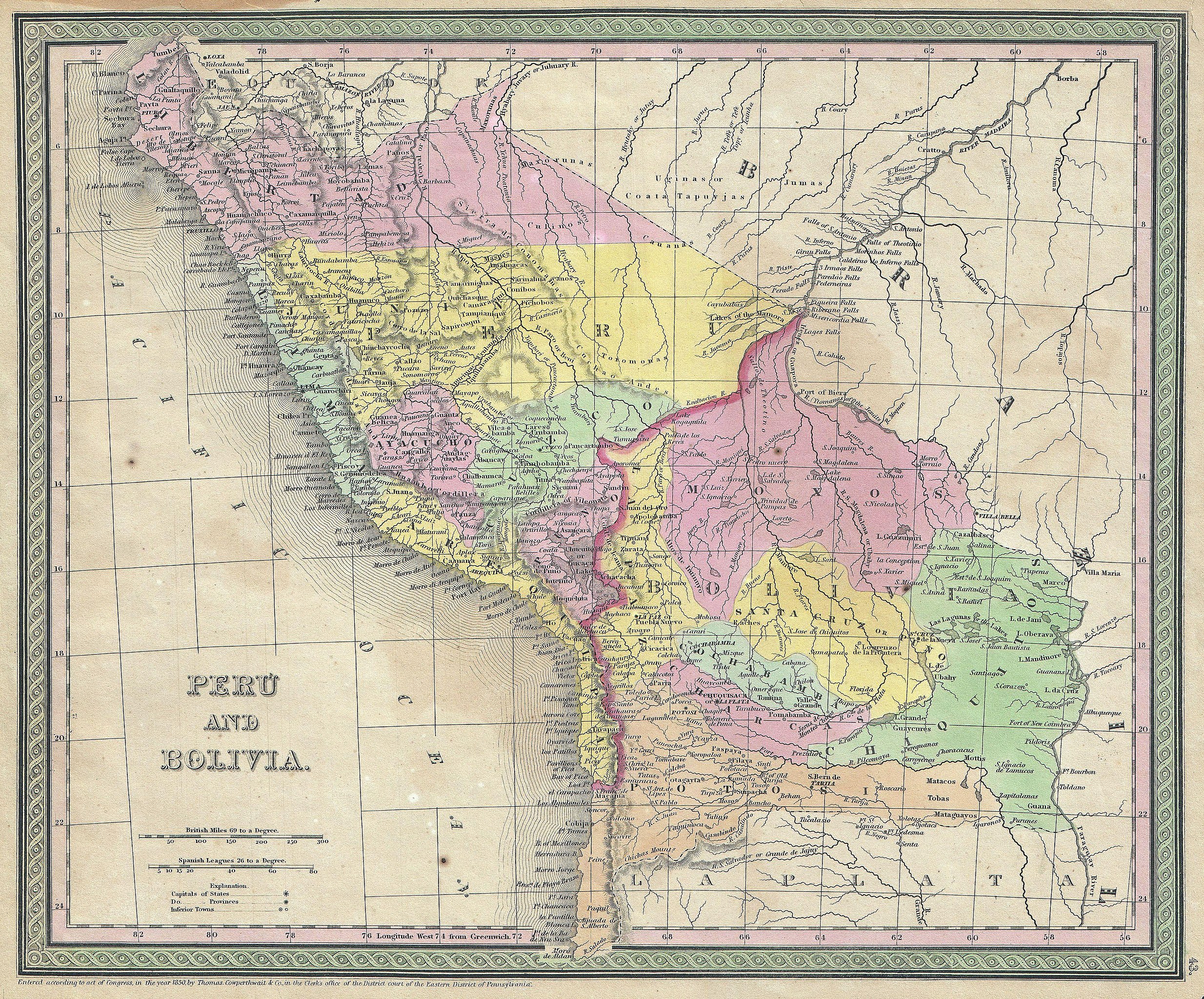
| Samuel Augustus Mitchell: Peru and Bolivia.
( |
||||||||||||||||||||
|---|---|---|---|---|---|---|---|---|---|---|---|---|---|---|---|---|---|---|---|---|
| Artista |
|
|||||||||||||||||||
| Título |
Peru and Bolivia. |
|||||||||||||||||||
| Descripción |
English: An attractive example of S. A. Mitchell Senior’s 1850 Map of Peru and Bolivia. Covers from Equator south to La Plata. When this map was made Bolivia had access to the sea through the province of Potosi – this territory is not controlled by Chili. Prepared by S. A. Mitchell for publication as plate no. 43 in T. Cowperthwait’s 1850 edition of Mitchell’s New Universal Atlas . |
|||||||||||||||||||
| Fecha | 1850 (dated) | |||||||||||||||||||
| Dimensiones | altura: 13 in (33 cm); ancho: 15 in (38,1 cm) | |||||||||||||||||||
| Número de inventario |
Geographicus link: PeruBolivia-mitchell-1850 |
|||||||||||||||||||
| Fuente/fotógrafo |
Mitchell S. A., A New Universal Atlas Containing Maps of the various Empires, Kingdoms, States and Republics Of The World. (1850 - 1853 issue)
|
|||||||||||||||||||
| Permiso (Reutilización de este archivo) |
|
|||||||||||||||||||
Historial del archivo
Haz clic sobre una fecha y hora para ver el archivo tal como apareció en ese momento.
| Fecha y hora | Miniatura | Dimensiones | Usuario | Comentario | |
|---|---|---|---|---|---|
| actual | 21:49 15 mar 2011 | | 3500 × 2904 (3,55 MB) | BotMultichill (discusión | contribs.) | {{subst:User:Multichill/Geographicus |link=http://www.geographicus.com/P/AntiqueMap/PeruBolivia-mitchell-1850 |product_name=1850 Mitchell Map of Peru and Bolivia |map_title=Peru and Bolivia. |description=An attractive example of S. A. Mitchell Senior’s |
No puedes sobrescribir este archivo.
Usos del archivo
La siguiente página usa este archivo:
Uso global del archivo
Las wikis siguientes utilizan este archivo:
- Uso en es.wikipedia.org
- Uso en pt.wikipedia.org