File:1865 Spruner Map Israel or Palestine post 70 AD.jpg
Прејди на прегледникот
Прејди на пребарувањето
Големина на овој преглед: 372 × 599 пиксели. Други разделности: 149 × 240 пиксели | 298 × 480 пиксели | 476 × 768 пиксели | 635 × 1.024 пиксели | 1.353 × 2.180 пиксели.
Изворна податотека (1.353 × 2.180 пиксели, големина: 1,39 МБ, MIME-тип: image/jpeg)
Описи
Описи
Опишете во еден ред што претставува податотекава
Опис[уреди]
| Автор |
|
||
| Опис |
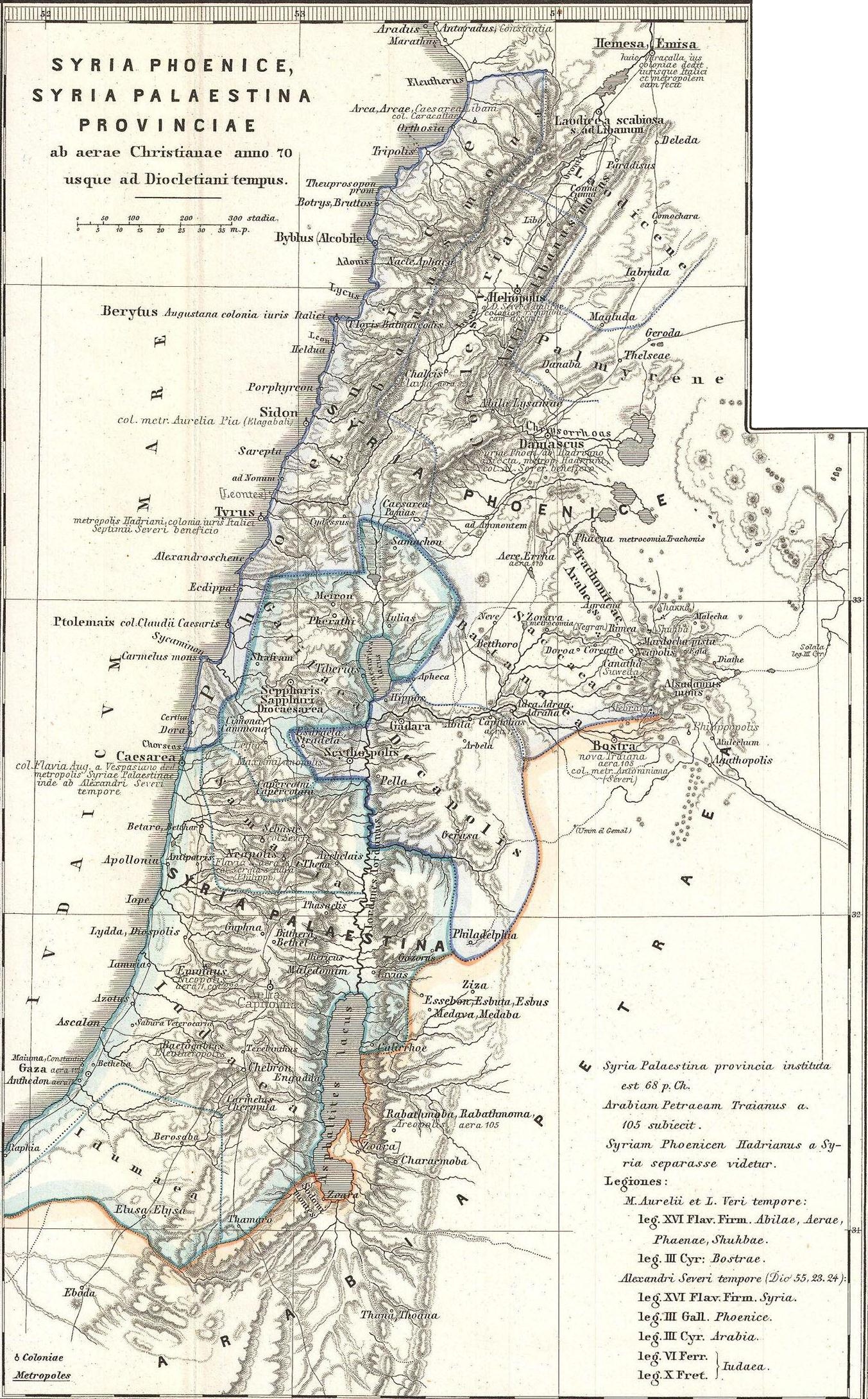
English: This is Karl von Spruner’s 1865 map of the Holy Land, or Israel and Palestine. Essentially nine maps in one, Spruner features two dominant maps and 7 smaller insets, including a Peutinger Table in the lower-right quadrant. The Peutinger Map is an astoundingly important discovery and is today’s only known example of a Roman world map, though the original Peutinger was itself a mediaeval copy of the Roman original. This map also shows, in counter-clock wise order from the Peutinger table, Galilaea, Hierosolyma, Judaea, Palestine at the time of Herod, Syria, Arabia, and Phoeniciae, Palestine, and Arabia. Many of the insets include their own scale or legend. Map notes important cities, rivers, mountain ranges and other minor topographical detail. Territories and countries outlined in color. The whole is rendered in finely engraved detail exhibiting throughout the fine craftsmanship of the Perthes firm. |
||
| Датум | 1865 (undated) | ||
| Димензии | висина: 16 инчи (40,6 см); ширина: 13 инчи (33 см) | ||
| Пописен бр. |
Geographicus link: Phoenice-spruner-1865 |
||
| Извор/Фотограф |
Оваа податотека е изведена од: 1865 Spruner Map of the Holy Land, Israel, or Palestine in Antiquity - Geographicus - Phoenice-spruner-1865.jpg: |
| Ова е ретуширана слика, што значи дека е дигитално променета (обработена) од изворната верзија. Обработки: Map divided into 2/3 parts (maps). Оригиналот може да се види тука: 1865 Spruner Map of the Holy Land, Israel, or Palestine in Antiquity - Geographicus - Phoenice-spruner-1865.jpg:
|
Лиценцирање[уреди]
|
Дводимензионалното уметничко дело представено на оваа слика е во јавна сопственост во целиот свет во согласност со смртта на авторот или датумот на издавање.
Поради тоа, оваа репродукција на делото исто така е во јавна сопственост. Ова се однесува на репродукцијата направена во САД (погл. Bridgeman Art Library v. Corel Corp.), во Германија, како и во многу други земји.
| ||||
Изворна евиденција за подигањето[уреди]
This image is a derivative work of the following images:
- File:1865_Spruner_Map_of_the_Holy_Land,_Israel,_or_Palestine_in_Antiquity_-_Geographicus_-_Phoenice-spruner-1865.jpg licensed with PD-Art
- 2011-03-25T05:57:05Z BotMultichillT 3500x2897 (2712725 Bytes) {{subst:User:Multichill/Geographicus |link=http://www.geographicus.com/P/AntiqueMap/Phoenice-spruner-1865 |product_name=1865 Spruner Map of the Holy Land, Israel, or Palestine in Antiquity |map_title=Phoenice, Coelesyria, Dec
Uploaded with derivativeFX
Историја на податотеката
Стиснете на датум/време за да ја видите податотеката како изгледала тогаш.
| Датум/време | Минијатура | Димензии | Корисник | Коментар | |
|---|---|---|---|---|---|
| тековна | 08:29, 10 јануари 2013 | | 1.353 × 2.180 (1,39 МБ) | Cristiano64 (разговор | придонеси) | == {{int:filedesc}} == {{Information |Description={{en|This is Karl von Spruner’s 1865 map of the Holy Land, or Israel and Palestine. Essentially nine maps in one, Spruner features two dominant maps and 7 smaller insets, including a Peutinger Table ... |
Не можете да презапишете врз податотекава.
Употреба на податотеката
Податотекава се користи во следниве 2 страници:
Глобална употреба на податотеката
Оваа податотека ја користат и следниве викија:
- Употреба на ar.wikipedia.org
- Употреба на en.wikipedia.org
- Употреба на eo.wikipedia.org
- Употреба на it.wikipedia.org
- Употреба на mk.wikipedia.org
- Употреба на mt.wikipedia.org
- Употреба на ru.wikipedia.org
- Употреба на zh.wikipedia.org