File:A chart of the bay and harbour of Pensacola in the Province of West Florida. LOC 77693968.tif
Jump to navigation
Jump to search
Size of this JPG preview of this TIF file: 800 × 594 pixels. Other resolutions: 320 × 238 pixels | 640 × 475 pixels | 1,024 × 760 pixels | 1,280 × 950 pixels | 2,560 × 1,901 pixels | 9,076 × 6,739 pixels.
Original file (9,076 × 6,739 pixels, file size: 174.99 MB, MIME type: image/tiff)
Captions
Captions
Add a one-line explanation of what this file represents
Summary[edit]
| Description |
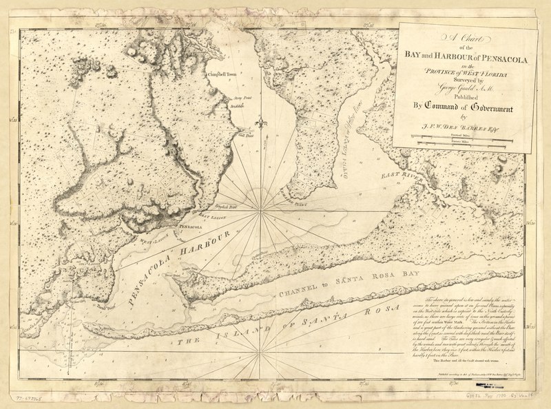
English: Scale ca. 1:64,000. Relief shown by hachures and shading. Depths shown by soundings. Includes text. LC Maps of North America, 1750-1789, 1663 Available also through the Library of Congress Web site as a raster image. Vault AACR2 |
||
| Title | A chart of the bay and harbour of Pensacola in the Province of West Florida. | ||
| Shelf ID | G3932.P45 1780 .G3 | ||
| Date | |||
| Source | https://www.loc.gov/item/77693968/ | ||
| Author | Gauld, George; Des Barres, Joseph F. W. (Joseph Frederick Wallet) | ||
| Permission (Reusing this file) |
|
||
| Other versions |
|
||
| Location | United States · Pensacola · Florida · Pensacola Bay | ||
| Part of | Military Battles And Campaigns · American Memory · Catalog · Geography And Map Division · American Revolution And Its Era: Maps And Charts Of North America And The West Indies, 1750-1789 | ||
| Subject | Pensacola Bay · Pensacola · Florida · Nautical Charts · Pensacola Bay (Fla.) · United States · Maps · Early Works To 1800 · Harbors |


Licensing[edit]
|
This is a faithful photographic reproduction of a two-dimensional, public domain work of art. The work of art itself is in the public domain for the following reason:
The official position taken by the Wikimedia Foundation is that "faithful reproductions of two-dimensional public domain works of art are public domain".
This photographic reproduction is therefore also considered to be in the public domain in the United States. In other jurisdictions, re-use of this content may be restricted; see Reuse of PD-Art photographs for details. | ||||
File history
Click on a date/time to view the file as it appeared at that time.
| Date/Time | Thumbnail | Dimensions | User | Comment | |
|---|---|---|---|---|---|
| current | 05:50, 5 June 2018 |  | 9,076 × 6,739 (174.99 MB) | Fæ (talk | contribs) | LOC Maps https://www.loc.gov/item/77693968/ #20499 |
You cannot overwrite this file.
File usage on Commons
The following page uses this file: