File:A map of the most inhabited part of Virginia containing the whole province of Maryland with part of Pensilvania, New Jersey and North Carolina - drawn by Joshua Fry & Peter Jefferson in 1775. NYPL434810.tiff
Jump to navigation
Jump to search

Size of this JPG preview of this TIF file: 502 × 599 pixels. Other resolutions: 201 × 240 pixels | 402 × 480 pixels | 643 × 768 pixels | 858 × 1,024 pixels | 1,716 × 2,048 pixels | 5,104 × 6,091 pixels.
Original file (5,104 × 6,091 pixels, file size: 88.95 MB, MIME type: image/tiff)
Captions
Captions
Add a one-line explanation of what this file represents
Summary
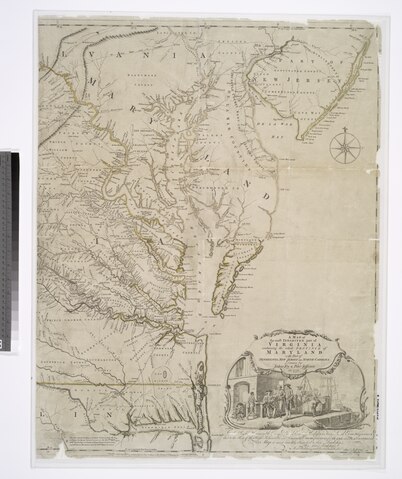
[edit]| Description | A map of the most inhabited part of Virginia containing the whole province of Maryland with part of Pensilvania, New Jersey and North Carolina / drawn by Joshua Fry & Peter Jefferson in 1775. | |||||||||||||||||||||||
| Notes | To the Right Honourable George Dunk, Earl of Halifax, First Lord Commissioner, and to the Rest of the Right Honourable and Honourable Commissioners, for Trade and Plantations. This map is most humbly inscribed to their Lordships. By their Lordships Most Obedient & most devoted humble servt. Thos. Jefferys. Note 2.) Described in: Fry & Jefferson map of Virginia and Maryland : facsimiles of the 1754 and 1794 printings. 1966. p. [21] Note 3.) Includes distance chart by J. Dalrymple and ill. Note 4.) Lawrence H. Slaughter Collection ; 64. Note 5.) National Endowment for the Humanities Grant for Access to Early Maps of the Middle Atlantic Seaboard. Note 6.) Prime meridian: Philadelphia and Curratuck Inlet. Note 7.) Relief shown pictorially. | |||||||||||||||||||||||
| Standard reference | Cumming, W.P. Southeast in early maps, 449 | |||||||||||||||||||||||
| Physical description | 1 map on 2 sheets : hand col. ; 79 x 121 cm., sheets 79 x 61 cm. | |||||||||||||||||||||||
| Catalog Call Number | Map Div. 01-5085 | |||||||||||||||||||||||
| Date | ||||||||||||||||||||||||
| Source |
http://digitalgallery.nypl.org/nypldigital/dgkeysearchdetail.cfm?imageID=434810
|
|||||||||||||||||||||||
| Author | Jefferson, Peter, 1708-1757 -- Cartographer ;Fry, Joshua, 1700 (ca.)-1754 -- CartographerSayer, Robert, 1725-1794 -- Publisher ;Jefferys, Thomas, d. 1771 -- Engraver | |||||||||||||||||||||||
| Permission (Reusing this file) |
From The Lionel Pincus & Princess Firyal Map Division. Released on a CC0 license.[1] | |||||||||||||||||||||||
| Digital ID | 434810 | |||||||||||||||||||||||
| Location | Stephen A. Schwarzman Building / The Lionel Pincus and Princess Firyal Map Division | |||||||||||||||||||||||
| NYPL digital item published | 3-2-2006; updated 3-25-2011 | |||||||||||||||||||||||

Licensing
[edit]| This file is made available under the Creative Commons CC0 1.0 Universal Public Domain Dedication. | |
| The person who associated a work with this deed has dedicated the work to the public domain by waiving all of their rights to the work worldwide under copyright law, including all related and neighboring rights, to the extent allowed by law. You can copy, modify, distribute and perform the work, even for commercial purposes, all without asking permission.
|
The making of this file was supported by Wikimedia UK.
To see other files made with the support of Wikimedia UK, please see the category Supported by Wikimedia UK.
|
File history
Click on a date/time to view the file as it appeared at that time.
| Date/Time | Thumbnail | Dimensions | User | Comment | |
|---|---|---|---|---|---|
| current | 15:56, 3 April 2014 |  | 5,104 × 6,091 (88.95 MB) | Fæ (talk | contribs) | =={{int:filedesc}}== {{NYPL_map |digital_id = 434810 |creators = Jefferson, Peter, 1708-1757 -- Cartographer ;Fry, Joshua, 1700 (ca.)-1754 -- Cartographer |record_id = 253442 |catalog_call_number = Map Div. 01-5085 |item_physical_description = 1 map... |
You cannot overwrite this file.
File usage on Commons
The following page uses this file: