File:A new map of Denmark and Sweden. ... NYPL1630439.tiff
Jump to navigation
Jump to search

Size of this JPG preview of this TIF file: 800 × 563 pixels. Other resolutions: 320 × 225 pixels | 640 × 450 pixels | 1,024 × 720 pixels | 1,280 × 900 pixels | 2,560 × 1,800 pixels | 7,230 × 5,084 pixels.
Original file (7,230 × 5,084 pixels, file size: 105.17 MB, MIME type: image/tiff)
Captions
Captions
Add a one-line explanation of what this file represents
Summary[edit]
| Description | A new map of Denmark and Sweden. ...; Lawrence H. Slaughter Collection of English maps, charts, globes, books and atlases / Atlases / The world described, or, A new and correct sett of maps : shewing the kingdoms and states in all the known parts of the earth, with the principal cities, and most considerable towns in the world ... / ... by Herman Moll, geographer ... The island marked Greenland is actually Spitsbergen. | |||||||||||||||||||||||
| Notes | To His Excellency John Lord Bishop of Bristol, Ld. Privy seal and Her Majesty's first Plenipotentiary at the Treaty of Utrecht ... dedicated ... ''Note 2.'') Insets: The north part of Norway, Lapland and Greenland; The Laplanders. | |||||||||||||||||||||||
| Catalogue call number | Map Div. 97-6053[LHS 329; atlas cases] | |||||||||||||||||||||||
| Item/Page/Plate | 14 | |||||||||||||||||||||||
| Standard reference | Variant of Phillips 554 | |||||||||||||||||||||||
| Date | circa 1736 | |||||||||||||||||||||||
| Source |
http://digitalgallery.nypl.org/nypldigital/dgkeysearchdetail.cfm?imageID=1630439
|
|||||||||||||||||||||||
| Author | Bowles, Thomas, 1694-1773 -- Bookseller; Moll, Herman, d. 1732 -- Cartographer | |||||||||||||||||||||||
| Permission (Reusing this file) |
From The Lionel Pincus and Princess Firyal Map Division. http://maps.nypl.org
|
|||||||||||||||||||||||
| Other versions | See categories below. | |||||||||||||||||||||||
| Source description | 1 atlas (65 leaves (most folded)) : 31 maps (most hand col.) ; 65 cm. | |||||||||||||||||||||||
| Location | Stephen A. Schwarzman Building / The Lionel Pincus and Princess Firyal Map Division | |||||||||||||||||||||||
| Digital item published | 5-12-2008; updated 1-9-2012 | |||||||||||||||||||||||
| Digital ID | 1630439 | |||||||||||||||||||||||

The making of this file was supported by Wikimedia UK.
To see other files made with the support of Wikimedia UK, please see the category Supported by Wikimedia UK.
|
File history
Click on a date/time to view the file as it appeared at that time.
| Date/Time | Thumbnail | Dimensions | User | Comment | |
|---|---|---|---|---|---|
| current | 20:50, 20 April 2014 | 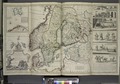 | 7,230 × 5,084 (105.17 MB) | Fæ (talk | contribs) | GWToolset:: Creating mediafile for Fæ. Tranche 2.1206 |
You cannot overwrite this file.
File usage on Commons
There are no pages that use this file.