File:Ancient Egypt map-en.svg

Archivo original (archivo SVG, nominalmente 1577 × 3219 píxeles, tamaño de archivo: 687 kB)
Leyendas
Leyendas
|
Resumen
[editar]| Descripción |
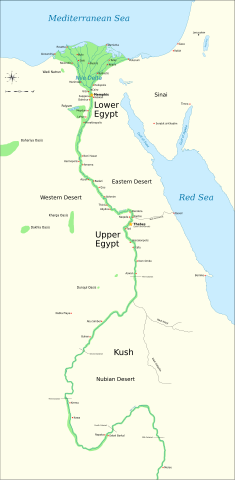
Català: Mapa de l'antic Egipte, que mostra el Nil fins a la cinquena cataracta, i les principals ciutats i llocs del període dinàstic (c. 3150 aC a 30 aC). El Caire i Jerusalem es mostren com a ciutats de referència.
English: Map of Ancient Egypt, showing the Nile up to the fifth cataract, and major cities and sites of the Dynastic period (c. 3150 BC to 30 BC). Cairo and Jerusalem are shown as reference cities. |
| Fecha | |
| Fuente |
Trabajo propio utilizando:
Coordinates:
|
| Autor | Jeff Dahl |
| Otras versiones |
File:Ancient Egypt map-en.svg has 5 translations.
Other related versions:[]
|


|
Este archivo SVG contiene texto incrustado que puede traducirse a su lengua, mediante un editor que admita SVG (como XML o texto). Para más información, véase: Sobre la traducción de archivos SVG. |
Este archivo se traduce usando elementos <switch> de SVG. ¡Todas las traducciones se almacenan en el propio archivo! Aprender más.
Para insertar este archivo en tu idioma (si está disponible) usa el parámetro Para traducir este archivo a tu idioma, puede usar la herramienta de traducción de SVG. Alternativamente, puedes descargar el archivo a tu ordenador, añadir la traducción utilizando cualquier software con el que estés familiarizado y resubirlo con el mismo nombre. Encontrarás más ayuda en el Taller de Ilustraciones / Laboratorio Gráfico si no estás seguro de cómo hacerlo. |
Licencia
[editar]

|
Se autoriza la copia, distribución y modificación de este documento bajo los términos de la licencia de documentación libre GNU, versión 1.2 o cualquier otra que posteriormente publique la Fundación para el Software Libre; sin secciones invariables, textos de portada, ni textos de contraportada. Se incluye una copia de la dicha licencia en la sección titulada Licencia de Documentación Libre GNU. |
- Eres libre:
- de compartir – de copiar, distribuir y transmitir el trabajo
- de remezclar – de adaptar el trabajo
- Bajo las siguientes condiciones:
- atribución – Debes otorgar el crédito correspondiente, proporcionar un enlace a la licencia e indicar si realizaste algún cambio. Puedes hacerlo de cualquier manera razonable pero no de manera que sugiera que el licenciante te respalda a ti o al uso que hagas del trabajo.
- compartir igual – En caso de mezclar, transformar o modificar este trabajo, deberás distribuir el trabajo resultante bajo la misma licencia o una compatible como el original.
Registro original de carga
[editar]
The original description page is/was here. All following user names refer to Commons.
- 2009-01-29 13:21 Bibi Saint-Pol 1577×3219×0 (412000 bytes) (remove wrong text, adjust frame)
- 2009-01-29 12:47 Bibi Saint-Pol 1577×3219×0 (413000 bytes) (added frame)
- 2009-01-29 12:35 Bibi Saint-Pol 1577×3219×0 (412000 bytes) (harmonize colors with the standards + replace unsupported Arial fonts by DejaVu )
- 2008-02-11 06:55 Jeff Dahl 1577×3219×0 (391000 bytes) (sp fx)
- 2007-11-29 02:09 Jeff Dahl 1577×3219×0 (391000 bytes) (Rotate Mediterranean Sea label)
- 2007-11-27 23:32 Jeff Dahl 1577×3219×0 (391000 bytes) (Minor adjustments to Naukratis and Buto)
- 2007-11-27 18:59 Jeff Dahl 1577×3219×0 (391000 bytes) (Cairo and Jerusalem now with black dots/italics)
- 2007-11-23 00:04 Jeff Dahl 1577×3219×0 (391000 bytes) (fx scalebar)
- 2007-11-22 23:56 Jeff Dahl 1577×3219×0 (391000 bytes) ({{Information |Description=A map of ancient Egypt, made with Inkscape |Source=self-made |Date=11-22-07 |Author= Jeff Dahl |Permission= |other_versions={{DerivativeVersions|Ancient Egypt map-ru.svg}} }} )
Historial del archivo
Haz clic sobre una fecha y hora para ver el archivo tal como apareció en ese momento.
| Fecha y hora | Miniatura | Dimensiones | Usuario | Comentario | |
|---|---|---|---|---|---|
| actual | 03:39 20 oct 2023 | | 1577 × 3219 (687 kB) | Haziq Faruqi (discusión | contribs.) | File uploaded using svgtranslate tool (https://svgtranslate.toolforge.org/). Added translation for ms. |
| 23:56 17 mar 2022 |  | 1577 × 3219 (626 kB) | Manlleus (discusión | contribs.) | File uploaded using svgtranslate tool (https://svgtranslate.toolforge.org/). Added translation for ca. | |
| 15:23 6 mar 2022 |  | 1577 × 3219 (564 kB) | Scratchinghead (discusión | contribs.) | File uploaded using svgtranslate tool (https://svgtranslate.toolforge.org/). Added translation for ta. | |
| 06:03 25 feb 2022 |  | 1577 × 3219 (564 kB) | Scratchinghead (discusión | contribs.) | File uploaded using svgtranslate tool (https://svgtranslate.toolforge.org/). Added translation for ta. | |
| 19:29 6 mar 2020 |  | 1577 × 3219 (501 kB) | Nilesh shukla (discusión | contribs.) | File uploaded using svgtranslate tool (https://tools.wmflabs.org/svgtranslate/). Added translation for hi. | |
| 11:28 20 feb 2009 |  | 1577 × 3219 (413 kB) | Bibi Saint-Pol (discusión | contribs.) | fix translation mistake on the windrose | |
| 12:13 30 ene 2009 |  | 1577 × 3219 (413 kB) | Bibi Saint-Pol (discusión | contribs.) | fix position of Nile Delta | |
| 12:21 29 ene 2009 |  | 1577 × 3219 (412 kB) | Bibi Saint-Pol (discusión | contribs.) | remove wrong text, adjust frame | |
| 12:05 29 ene 2009 |  | 1577 × 3219 (413 kB) | Bibi Saint-Pol (discusión | contribs.) | {{Assessments|1=Ancient Egypt map.svg|enwiki=1}} __NOTOC__ == {{int:filedesc}} == {{inkscape}} {{Information |Description= {{en|Map of Ancient Egypt, showing the Nile up to the fifth cataract, and major cities and sites of the Dynastic period (c. 3150 BC |
No puedes sobrescribir este archivo.
Usos del archivo
Las siguientes páginas usan este archivo:
- Atlas of Egypt
- Atlas of the antiquity
- User:Magog the Ogre/Multilingual legend/2020 March 1-10
- User:Magog the Ogre/Multilingual legend/2022 February 19-28
- User:Magog the Ogre/Multilingual legend/2022 March 1-10
- User:Magog the Ogre/Multilingual legend/2022 March 11-20
- User:Magog the Ogre/Multilingual legend/2023 October 17-21
- User:Sysy 19
- File:Ancient Egypt Map - en (Ancient Egyptian & Greek Names).svg
- File:Ancient Egypt main map.png
- File:Ancient Egypt map-af.svg
- File:Ancient Egypt map-ar.png
- File:Ancient Egypt map-de.svg
- File:Ancient Egypt map-el.png
- File:Ancient Egypt map-el.svg
- File:Ancient Egypt map-en.svg
- File:Ancient Egypt map-es.svg
- File:Ancient Egypt map-fr.svg
- File:Ancient Egypt map-hiero.svg
- File:Ancient Egypt map-it.svg
- File:Ancient Egypt map-la.png
- File:Ancient Egypt map-la.svg
- File:Ancient Egypt map-mk.svg
- File:Ancient Egypt map-nl.svg
- File:Ancient Egypt map-no.svg
- File:Ancient Egypt map-pl.svg
- File:Ancient Egypt map-pt.svg
- File:Ancient Egypt map-ru.svg
- File:Ancient Egypt map-sk.svg
- File:Ancient Egypt map-sr.svg
- File:Ancient Egypt map-vi.svg
- File:Ancient Egypt map-zh-hans.svg
- File:Ancient Egypt map.svg (archivo de redirección)
- File:Antik Mısır haritası.png
- File:Antzinako Egipto.svg
- File:Canal of the Pharaops-es.svg
- File:Egypt ancient detail wadi hammamat.png
- File:End of 19th Dynasty map-en.png
- File:Lower Egypt-en.png
- File:Mapo de antikva Egiptio.jpg
- File:Mapo de antikva Egiptio - centro.jpg
- File:Muistne Egiptus.png
- Template:Other versions/Ancient Egypt map
- Category:31st century BC
.svg)
Uso global del archivo
Las wikis siguientes utilizan este archivo:
- Uso en anp.wikipedia.org
- Uso en azb.wikipedia.org
- Uso en blk.wikipedia.org
- Uso en bn.wikipedia.org
- Uso en bs.wikipedia.org
- Uso en ca.wikipedia.org
- Uso en ceb.wikipedia.org
- Uso en ckb.wikipedia.org
- Uso en cs.wikipedia.org
- Uso en cv.wikipedia.org
- Uso en da.wikipedia.org
- Uso en en.wikipedia.org
- Ancient Egypt
- History of Africa
- Jean-François Champollion
- Old Kingdom of Egypt
- First Intermediate Period of Egypt
- 671 BC
- Wikipedia:WikiProject Former countries
- Cradle of civilization
- Portal:Africa
- Portal:Africa/Featured article
- Portal:Africa/Featured picture
- Portal:Ancient Egypt
- Portal:Ancient Egypt/Selected picture
- Portal talk:Africa/Featured picture
- Africa
- Portal:Maps/Selected picture
- Thinite Confederacy
- Portal:Africa/Featured article/2
- Wikipedia:Featured pictures thumbs/09
- Wikipedia:Picture peer review/Ancient Egypt main map
- Wikipedia:Featured picture candidates/November-2007
- Wikipedia:Featured picture candidates/Ancient Egypt map-en.svg
- Wikipedia:Wikipedia Signpost/2007-12-03/Features and admins
- Portal:Africa/Featured picture/22
- Portal:Maps/Selected picture/32
- User talk:Jeff Dahl/Archive 2
- Portal:Ancient Egypt/Selected picture/2
- User talk:Jeff Dahl/Archive 3
Ver más uso global de este archivo.