File:Assassination attempt of Donald Trump diagram.svg

Original file (SVG file, nominally 512 × 637 pixels, file size: 18 KB)
Captions
Captions
Summary
[edit]
| Description |
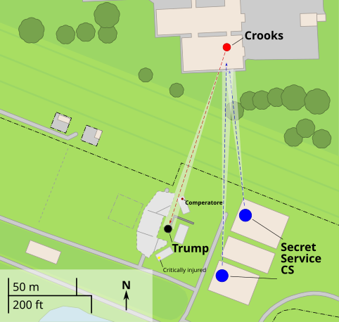
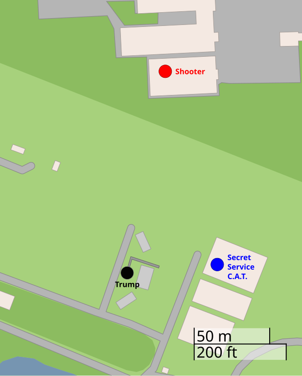
English: A diagram illustrating the approximate locations of Thomas Matthew Crooks (red), Donald Trump (black), and the Secret Service Counter Assault Team (blue) during the attempted assassination of Donald Trump in July 2024
Français : Un diagramme illustrant les emplacements approximatifs de Thomas Matthew Crooks (rouge), Donald Trump (noir) et l'équipe de contre-embuscade (E.C.E) du Secret Service (bleu)
Nederlands: Plattegrond van de bijeenkomst tijdens de moordpoging van Donald Trump met geschatte locaties van Trump (zwart), Crooks (rood), en de tegenaanvalteam van de geheime dienst (SSCAT) (blauw) |
|||
| SVG development | ||||
| Date | ||||
| Source | openstreetmap.org | |||
| Creator |
OpenStreetMap contributors |
|||
| Permission (Reusing this file) |
OpenStreetMap data is available under the Open Database License (details). Standard style map tiles are licensed as ODbL Produced Works.
|
|||
| Georeferencing | If inappropriate please set warp_status = skip to hide. |
References
[edit]
Sources of labeled locations:[1][2]
Diagram of the stage derived from aerial footage of the aftermath.[3]
- ↑ (2024-07-13). "Shooting at a Trump Rally in Pennsylvania: Maps and Photos". The New York Times. ISSN 0362-4331.
- ↑ Trump injured, rushed from stage after shooter fired on his Pennsylvania rally (in en). NBC News (2024-07-13). Archived from the original on July 14, 2024. Retrieved on 2024-07-14.
- ↑ Aerial footage of scene after shooting at Trump rally in Butler, Pennsylvania. WFXG FOX54 (2024-07-13). Retrieved on 2024-07-14.
Licensing
[edit]
| This work contains information from OpenStreetMap, which is made available under the Open Database License (ODbL).
The ODbL does not require any particular license for maps produced from ODbL data. Prior to 1 August 2020, map tiles produced by the OpenStreetMap Foundation were licensed under the CC-BY-SA-2.0 license. Maps produced by other people may be subject to other licences. |
File history
Click on a date/time to view the file as it appeared at that time.
| Date/Time | Thumbnail | Dimensions | User | Comment | |
|---|---|---|---|---|---|
| current | 21:42, 14 July 2024 | | 512 × 637 (18 KB) | Ђидо (talk | contribs) | File uploaded using svgtranslate tool (https://svgtranslate.toolforge.org/). Added translation for sr-cyrl. |
| 20:53, 14 July 2024 |  | 512 × 637 (18 KB) | Pottero (talk | contribs) | File uploaded using svgtranslate tool (https://svgtranslate.toolforge.org/). Added translation for pl. | |
| 18:00, 14 July 2024 |  | 512 × 637 (17 KB) | Glrx (talk | contribs) | fix duped ids | |
| 17:56, 14 July 2024 |  | 512 × 637 (17 KB) | Glrx (talk | contribs) | don't stroke text in scale | |
| 17:45, 14 July 2024 |  | 512 × 637 (17 KB) | Glrx (talk | contribs) | delete unref'd clipPath; add clipPath; delete width, height on svg element | |
| 17:33, 14 July 2024 |  | 638 × 793 (17 KB) | Glrx (talk | contribs) | +en; promote formating to switch | |
| 16:42, 14 July 2024 |  | 638 × 793 (21 KB) | Minwuekim (talk | contribs) | File uploaded using svgtranslate tool (https://svgtranslate.toolforge.org/). Added translation for ko. | |
| 15:55, 14 July 2024 |  | 638 × 793 (20 KB) | Howardcorn33 (talk | contribs) | File uploaded using svgtranslate tool (https://svgtranslate.toolforge.org/). Added translation for tr. | |
| 14:48, 14 July 2024 |  | 638 × 793 (19 KB) | Howardcorn33 (talk | contribs) | File uploaded using svgtranslate tool (https://svgtranslate.toolforge.org/). Added translation for nl. | |
| 14:18, 14 July 2024 |  | 638 × 793 (19 KB) | Octopus456 (talk | contribs) | File uploaded using svgtranslate tool (https://svgtranslate.toolforge.org/). Added translation for pt. |
You cannot overwrite this file.
File usage on Commons
The following 2 pages use this file:
File usage on other wikis
The following other wikis use this file:
- Usage on ar.wikipedia.org
- Usage on be-tarask.wikipedia.org
- Usage on ca.wikipedia.org
- Usage on cy.wikipedia.org
- Usage on en.wikipedia.org
- Usage on es.wikipedia.org
- Usage on et.wikipedia.org
- Usage on fi.wikipedia.org
- Usage on ga.wikipedia.org
- Usage on hu.wikipedia.org
- Usage on id.wikipedia.org
- Usage on it.wikipedia.org
- Usage on kk.wikipedia.org
- Usage on ko.wikipedia.org
- Usage on nl.wikipedia.org
- Usage on pl.wikipedia.org
- Usage on pt.wikipedia.org
- Usage on sd.wikipedia.org
- Usage on sr.wikipedia.org
- Usage on tr.wikipedia.org
- Usage on www.wikidata.org