File:Bali regions map.svg
Jump to navigation
Jump to search

Size of this PNG preview of this SVG file: 800 × 455 pixels. Other resolutions: 320 × 182 pixels | 640 × 364 pixels | 1,024 × 582 pixels | 1,280 × 727 pixels | 2,560 × 1,455 pixels | 3,044 × 1,730 pixels.
Original file (SVG file, nominally 3,044 × 1,730 pixels, file size: 1.19 MB)
Captions
Captions
Add a one-line explanation of what this file represents
Summary
[edit]
| Description |
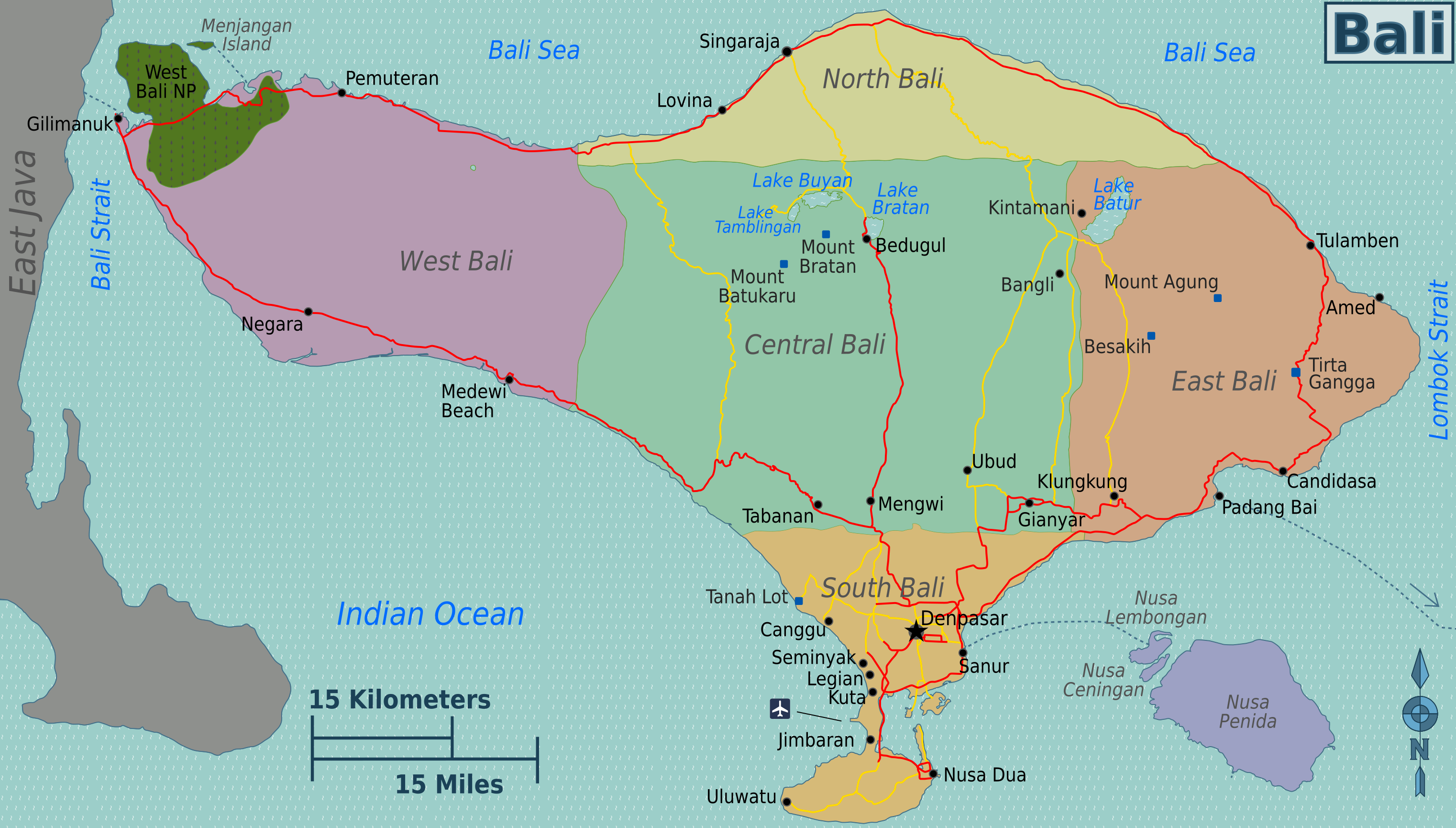
Bali regions map (SVG source file). |
| Date | |
| Source | Own work based on OpenStreetMap.org [1], Bali map region.jpg by Burmesedays, PD satellite imagery, and Topography of Bali.jpg. |
| Author | Burmesedays, Peterfitzgerald (Peter Fitzgerald). |
| Other versions | English, French, Japanese, Bali regions map straight lines.png |
.png)
.png)
Licensing
[edit]
This file is licensed under the Creative Commons Attribution-Share Alike Attribution-Share Alike 4.0 International, 3.0 Unported, 2.5 Generic, 2.0 Generic and 1.0 Generic license.
- You are free:
- to share – to copy, distribute and transmit the work
- to remix – to adapt the work
- Under the following conditions:
- attribution – You must give appropriate credit, provide a link to the license, and indicate if changes were made. You may do so in any reasonable manner, but not in any way that suggests the licensor endorses you or your use.
- share alike – If you remix, transform, or build upon the material, you must distribute your contributions under the same or compatible license as the original.
Original upload log
[edit]
| This file was imported from Wikivoyage WTS. |
The original description page was here. All following user names refer to wts.wikivoyage-old.
- 2009-10-21 04:37 (WT-shared) Peterfitzgerald archive copy at the Wayback Machine 400×374 (1181565 bytes) {{Imagecredit|credit=[[User:Burmesedays]], Peter Fitzgerald, [http://openstreetmap.org OpenStreetMap]|captureDate=21 October 2009|location=B (Import from wikitravel.org/shared)
- 2009-10-26 22:19 (WT-shared) Peterfitzgerald archive copy at the Wayback Machine 400×374 (1298612 bytes) updates per talk, new color scheme, squiggled (Import from wikitravel.org/shared)
- 2009-10-29 02:13 (WT-shared) Peterfitzgerald archive copy at the Wayback Machine 400×374 (1411708 bytes) back to polychromatic color scheme, fixes per talk (Import from wikitravel.org/shared)
- 2009-11-02 03:23 (WT-shared) Burmesedays[dead link] 400×374 (1412004 bytes) temporary marking of West Bali NP eastern boundary and some small fixes as per talk (Import from wikitravel.org/shared)
- 2009-11-02 03:37 (WT-shared) Peterfitzgerald archive copy at the Wayback Machine 400×374 (1411708 bytes) WBNP boundary fix, other minor fixes (Import from wikitravel.org/shared)
- 2011-08-28 04:14 (WT-shared) Joelf[dead link] 3044×1730 (1251238 bytes) +fr (Import from wikitravel.org/shared)
File history
Click on a date/time to view the file as it appeared at that time.
| Date/Time | Thumbnail | Dimensions | User | Comment | |
|---|---|---|---|---|---|
| current | 05:28, 21 November 2012 | | 3,044 × 1,730 (1.19 MB) | OgreBot (talk | contribs) | (BOT): Reverting to most recent version before archival |
| 05:28, 21 November 2012 |  | 400 × 374 (1.35 MB) | OgreBot (talk | contribs) | (BOT): Uploading old version of file from wts.wikivoyage; originally uploaded on 2009-11-02 03:37:24 by (WT-shared) Peterfitzgerald | |
| 05:28, 21 November 2012 |  | 400 × 374 (1.35 MB) | OgreBot (talk | contribs) | (BOT): Uploading old version of file from wts.wikivoyage; originally uploaded on 2009-11-02 03:23:19 by (WT-shared) Burmesedays | |
| 05:28, 21 November 2012 |  | 400 × 374 (1.35 MB) | OgreBot (talk | contribs) | (BOT): Uploading old version of file from wts.wikivoyage; originally uploaded on 2009-10-29 02:13:59 by (WT-shared) Peterfitzgerald | |
| 05:27, 21 November 2012 |  | 400 × 374 (1.24 MB) | OgreBot (talk | contribs) | (BOT): Uploading old version of file from wts.wikivoyage; originally uploaded on 2009-10-26 22:19:32 by (WT-shared) Peterfitzgerald | |
| 05:27, 21 November 2012 |  | 400 × 374 (1.13 MB) | OgreBot (talk | contribs) | (BOT): Uploading old version of file from wts.wikivoyage; originally uploaded on 2009-10-21 04:37:05 by (WT-shared) Peterfitzgerald | |
| 22:05, 17 November 2012 |  | 3,044 × 1,730 (1.19 MB) | MGA73bot2 (talk | contribs) | {{BotMoveToCommons|wts.oldwikivoyage|year={{subst:CURRENTYEAR}}|month={{subst:CURRENTMONTHNAME}}|day={{subst:CURRENTDAY}}}} == {{int:filedesc}} == {{Information |description=Bali regions map. SVG, Bali * Map of: Bali¤ '''PNG files:''' *[[:wts::Image:B... |
You cannot overwrite this file.
File usage on Commons
There are no pages that use this file.