File:Belarus provinces.svg
Jump to navigation
Jump to search

Size of this PNG preview of this SVG file: 424 × 600 pixels. Other resolutions: 170 × 240 pixels | 339 × 480 pixels | 543 × 768 pixels | 724 × 1,024 pixels | 1,448 × 2,048 pixels | 744 × 1,052 pixels.
Original file (SVG file, nominally 744 × 1,052 pixels, file size: 198 KB)
Captions
Captions
Add a one-line explanation of what this file represents
Summary[edit]
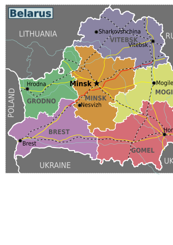
| Description | Regional map of Belarus (Wikivoyage regional scheme), multilingual SVG source |
| Date | |
| Source | Own work based on the blank map of Belarus |
| Author | Arz, Stefan Ertmann, Russian translation by Digr |
| Other versions |
.png)
Licensing[edit]

|
Permission is granted to copy, distribute and/or modify this document under the terms of the GNU Free Documentation License, Version 1.2 or any later version published by the Free Software Foundation; with no Invariant Sections, no Front-Cover Texts, and no Back-Cover Texts. A copy of the license is included in the section entitled GNU Free Documentation License. |
This file is licensed under the Creative Commons Attribution-Share Alike 4.0 International, 3.0 Unported, 2.5 Generic, 2.0 Generic and 1.0 Generic license.
- You are free:
- to share – to copy, distribute and transmit the work
- to remix – to adapt the work
- Under the following conditions:
- attribution – You must give appropriate credit, provide a link to the license, and indicate if changes were made. You may do so in any reasonable manner, but not in any way that suggests the licensor endorses you or your use.
- share alike – If you remix, transform, or build upon the material, you must distribute your contributions under the same or compatible license as the original.
Original upload log[edit]
| This file was imported from Wikivoyage WTS. |
The original description page was here. All following user names refer to wts.wikivoyage-old.
- 2009-03-22 16:46 (WT-shared) Sertmann[dead link] 850×725 (171873 bytes) {{Imagecredit|credit=Stefan Ertmann|captureDate=March 2009|location=Belarus|source=http://cs.wikipedia.org/wiki/Soubor:Belarus_provinces_bla (Import from wikitravel.org/shared)
File history
Click on a date/time to view the file as it appeared at that time.
| Date/Time | Thumbnail | Dimensions | User | Comment | |
|---|---|---|---|---|---|
| current | 12:06, 28 April 2013 | | 744 × 1,052 (198 KB) | Voll (talk | contribs) | Text moved to new layers in SVG, created english, russian and ukrainian layers |
| 22:43, 17 November 2012 |  | 850 × 725 (168 KB) | MGA73bot2 (talk | contribs) | {{BotMoveToCommons|wts.oldwikivoyage|year={{subst:CURRENTYEAR}}|month={{subst:CURRENTMONTHNAME}}|day={{subst:CURRENTDAY}}}} == {{int:filedesc}} == {{Information |description=Map of Belarus. Belearus map with regions<br>PNG version [[:wts::Image:Belarus... |
You cannot overwrite this file.
File usage on Commons
There are no pages that use this file.