File:Byzantine empire 1355.jpg
ナビゲーションに移動
検索に移動

このプレビューのサイズ: 758 × 600 ピクセル。 その他の解像度: 304 × 240 ピクセル | 607 × 480 ピクセル | 971 × 768 ピクセル | 1,134 × 897 ピクセル。
元のファイル (1,134 × 897 ピクセル、ファイルサイズ: 380キロバイト、MIME タイプ: image/jpeg)
キャプション
キャプション
このファイルの内容を1行で記述してください
概要
[編集]| 解説 |
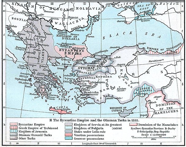
English: Map of the Byzantine, Ottoman and Serbian empires and their neighboring states, 1355. |
| 日付 | |
| 原典 | William R. Shepherd's Historical Atlas, p. 89, published by Henry Holt and Company, New York 1911 |
| 作者 | |
| その他のバージョン |
|

ライセンス
[編集]
|
パブリックドメインの状態にある著作物をウィキメディア・コモンズに置くためには、アメリカ合衆国と著作物の本国の双方において著作権の保護期間が満了している必要があります。この著作物がアメリカ合衆国のものでない場合には、ファイルに対してその本国における著作権状況を示す著作権タグを付加する必要があります。
|
ファイルの履歴
過去の版のファイルを表示するには、その版の日時をクリックしてください。
| 日付と時刻 | サムネイル | 寸法 | 利用者 | コメント | |
|---|---|---|---|---|---|
| 現在の版 | 2022年12月6日 (火) 20:53 | | 1,134 × 897 (380キロバイト) | Gyalu22 (トーク | 投稿記録) | Artwork |
| 2018年3月29日 (木) 16:44 |  | 1,112 × 879 (908キロバイト) | Nihil scimus (トーク | 投稿記録) | Few improving (esthetic, contrast, genoese possessions 1355 since Westermann Grosser Atlas zur Weltgeschichte, 1985, ISBN 3-14-100919-8, p. 70, wallachian possessions 1355 under Nicholas Alexander [https://commons.wikimedia.org/wiki/File:Nicolae_Alexandru.jpg] since [https://en.wikipedia.org/wiki/Wallachia#/media/File:Wallachia_13-16c.svg]). | |
| 2009年11月8日 (日) 13:17 |  | 1,134 × 897 (380キロバイト) | Alex:D (トーク | 投稿記録) | whitened | |
| 2005年12月3日 (土) 16:00 |  | 1,134 × 897 (269キロバイト) | Migdejong (トーク | 投稿記録) | Map of the Byzantine Empire in the year 1355. Image comes from the University of Texas at Austin: http://geography.about.com/gi/dynamic/offsite.htm?site=http://www.lib.utexas.edu/maps/historical/history%5Feurope.html Map is released into the public |
このファイルは上書きできません。
ファイルの使用状況
以下の 17 ページがこのファイルを使用しています:
- Atlas of Albania
- Atlas of Bosnia and Herzegovina
- Atlas of Cyprus
- Atlas of Greece
- Atlas of Kosovo
- Atlas of Montenegro
- Atlas of North Macedonia
- Atlas of Northern Cyprus
- Atlas of Republika Srpska
- Atlas of Serbia
- Atlas of Turkey
- Atlas of ancient Rome
- Atlas of the Byzantine Empire
- Byzantine Empire
- User:J budissin/Uploads/BiH/2018 March 21-31
- File:Byzantine Empire 1355.jpg
- File:Serbian Empire 1355-cs.png
グローバルなファイル使用状況
以下に挙げる他のウィキがこの画像を使っています:
- ar.wikipedia.org での使用状況
- azb.wikipedia.org での使用状況
- az.wikipedia.org での使用状況
- ba.wikipedia.org での使用状況
- bg.wikipedia.org での使用状況
- bs.wikipedia.org での使用状況
- ca.wikipedia.org での使用状況
- de.wikipedia.org での使用状況
- Byzantinisches Reich
- Makedonien
- 1355
- Großserbien
- Marino Falier
- Andronikos IV.
- Beylik von Aydın
- Eroberung von Philadelphia
- Eroberung von Gallipoli
- Byzantinisch-genuesischer Krieg (1348–1349)
- Byzantinischer Bürgerkrieg (1352–1357)
- Byzantinischer Bürgerkrieg (1373–1381)
- Kreuzzug von Smyrna
- Benutzer:GerardM/Battles including the Ottoman Empire
- el.wikipedia.org での使用状況
- en.wikipedia.org での使用状況
このファイルのグローバル使用状況を表示する。
メタデータ
カテゴリ:
- Old maps of the Byzantine Empire
- Maps showing history by William R. Shepherd
- William R. Shepherd
- Maps of the history of the medieval Balkans
- Maps of the Serbian Empire
- Maps of the history of North Macedonia in the Middle Ages
- Maps of 14th-century Bulgaria
- Maps of the history of Romania in the Middle Ages
- Maps showing 1355
- Maps of 14th-century Serbia
- Maps of the Ottoman Empire in the 14th century