File:Cha Chay Pay Way Ti’s Map of the Waterways of a Part of Northern Manitoba (1806).jpg
Original file (2,336 × 3,504 pixels, file size: 3.05 MB, MIME type: image/jpeg)
Captions
Captions
Summary
[edit]| Description |
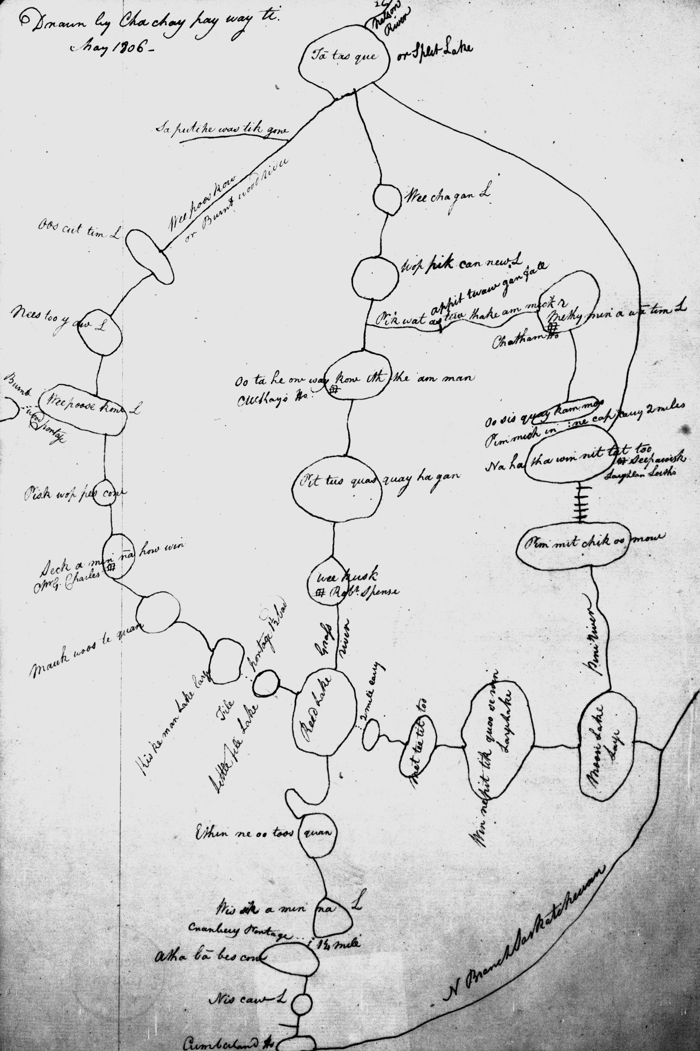
Fidler, Peter. Cha Chay Pay Way Ti’s Map of the Waterways of a Part of Northern Manitoba 1806 [facsimile]. [1:1,267,200]. In: John Warkentin and Richard I. Ruggles. Manitoba Historical Atlas : a Selection of Facsimile Maps, Plans, and Sketches from 1612 to 1969. Winnipeg: Historical and Scientific Society of Manitoba, 1969, p. 142. As reproduced by, Winnipeg: Historical and Scientific Society of Manitoba. This is a fascinating map of a complex area of waterways between Cumberland House and Split Lake, and shows how greatly the European explores must have been assisted by the natives in picking their way through the lake country of northern Canada. Peter Fidler was at Fort Chipewyan on Lake Athabaska in the spring of 1806, and it would appear that Cha chay pay way ti must have drawn the map for him there. Fidler, of course, was interested in all routes between the Far West and York Factory and likely asked knowledgeable Indians for assistance in charting routes. First a word about the scale. The distance between Cumberland House and Split Lake is about 270 miles, and it is apparent that Cha chay pay ti drew a fairly accurate sketch of a great extent of country. He made no attempt to show the outlines of lakes precisely, preferring, in the way models are drawn, to indicate lakes by circles or ovals, and connecting them by simple straight lines. Some classic routes in the Manitoba North are shown. The circuitous route to the north is that of the Burntwood river, the central is that by the Grass river, and the southern is via the present Minago, and then by either the Pikwitonei or Nelson rivers. Names of some of the rivers are familiar today: Wekusko, Sipiwesk, Reed and Moose; Burntwood, Grass and Saskatchewan. And of course, notorious Cranberry Portage. Naturally, a reconnaissance survey would be required to position the lakes and rivers named on this map accurately and get correct outlines, but the sequential spacing is very good and would serve to guide an explorer well. Cross links have also been drawn from Moose to Reed Lake and from Sipiwesk Lake to Grass river, and some of the trading posts are marked. (Warkentin and Ruggles. Historical Atlas of Manitoba. map 55, p. 142) The map was redrawn by Peter Fidler in one of his journals. Manuscript map, ink on paper. The original map is in the Hudson’s Bay Company Archives, London, England (E. ¾, fo. 13d). |
|||
| Date | ||||
| Source | Cha Chay Pay Way Ti’s Map of the Waterways of a Part of Northern Manitoba (1806) | |||
| Author | Cha Chay Pay Way Ti, Peter Fidler via Manitoba Historical Maps | |||
| Permission (Reusing this file) |
|

.jpg&action=edit§ion=1)
Licensing
[edit].jpg&action=edit§ion=2)
- You are free:
- to share – to copy, distribute and transmit the work
- to remix – to adapt the work
- Under the following conditions:
- attribution – You must give appropriate credit, provide a link to the license, and indicate if changes were made. You may do so in any reasonable manner, but not in any way that suggests the licensor endorses you or your use.
| This image was originally posted to Flickr by Manitoba Historical Maps at https://www.flickr.com/photos/11496488@N07/2184928901. It was reviewed on 6 March 2011 by FlickreviewR and was confirmed to be licensed under the terms of the cc-by-2.0. |
File history
Click on a date/time to view the file as it appeared at that time.
| Date/Time | Thumbnail | Dimensions | User | Comment | |
|---|---|---|---|---|---|
| current | 20:22, 6 March 2011 | | 2,336 × 3,504 (3.05 MB) | FlickreviewR (talk | contribs) | Replacing image by its original image from Flickr |
| 20:05, 6 March 2011 |  | 333 × 500 (81 KB) | Geo Swan (talk | contribs) | {{Information |Description=Fidler, Peter. Cha Chay Pay Way Ti’s Map of the Waterways of a Part of Northern Manitoba 1806 [facsimile]. [1:1,267,200]. In: John Warkentin and Richard I. Ruggles. Manitoba Historical Atlas : a Selection of Facsimile Maps, Pl |
You cannot overwrite this file.
File usage on Commons
There are no pages that use this file.
File usage on other wikis
The following other wikis use this file:
- Usage on en.wikipedia.org
.jpg&oldid=889976416)