File:Chicago neighborhoods map.png
Jump to navigation
Jump to search

Size of this preview: 750 × 600 pixels. Other resolutions: 300 × 240 pixels | 601 × 480 pixels | 961 × 768 pixels | 1,280 × 1,023 pixels | 2,000 × 1,599 pixels.
Original file (2,000 × 1,599 pixels, file size: 406 KB, MIME type: image/png)
Captions
Captions
Add a one-line explanation of what this file represents
Summary
[edit]
| Description |
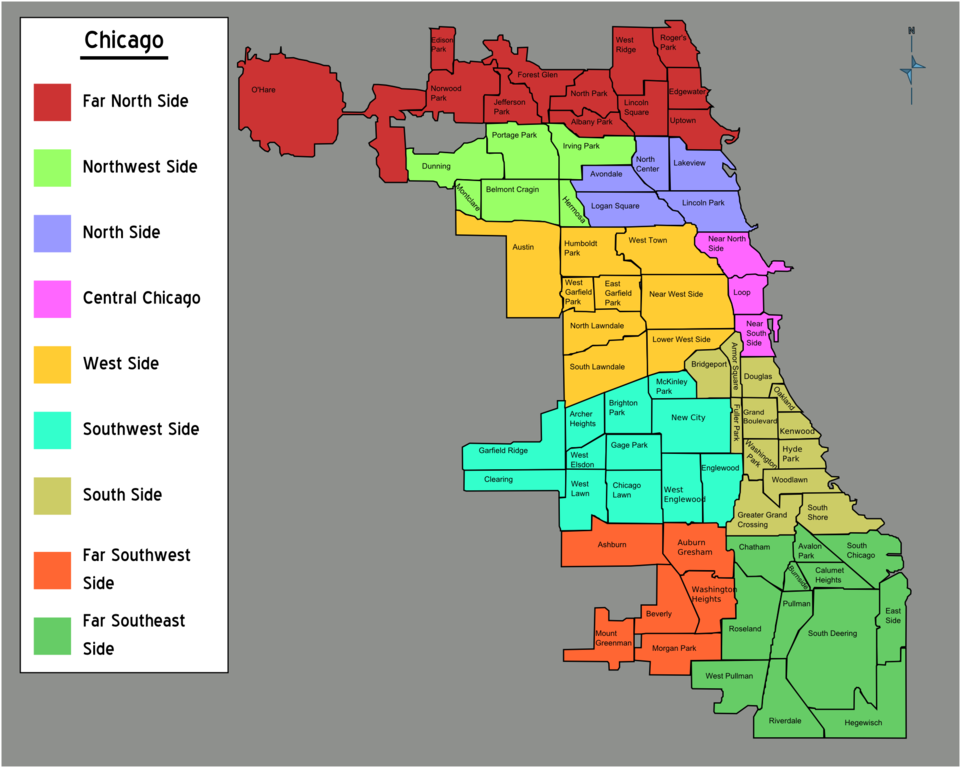
English: Chicago Hoods Map. Individual neighborhoods according to a 1920 UChicago census proposal; sides by color, Chicago. |
| Date | |
| Source | Chicago_neighborhoods_outline.svg |
| Author | Peter Fitzgerald |
Licensing
[edit]
| This work has been released into the public domain by its author, User: (WT-shared) Peterfitzgerald at wts wikivoyage. This applies worldwide. In some countries this may not be legally possible; if so: User: (WT-shared) Peterfitzgerald at wts wikivoyage grants anyone the right to use this work for any purpose, without any conditions, unless such conditions are required by law.
|
Original upload log
[edit]
| This file was imported from Wikivoyage WTS. |
The original description page was here. All following user names refer to wts.wikivoyage-old.
- 2007-05-06 21:32 (WT-shared) Peterfitzgerald archive copy at the Wayback Machine 5012×4006 (1285538 bytes) {{Imagecredit|credit=Peter Fitzgerald|captureDate=6 May 2007|location=Chicago|source=[[Chicago_neighborhoods_outline.svg]]|caption=Chicago H (Import from wikitravel.org/shared)
- 2007-05-06 21:49 (WT-shared) Peterfitzgerald archive copy at the Wayback Machine 2000×1599 (438500 bytes) {{Imagecredit|credit=Peter Fitzgerald|captureDate=6 May 2007|location=Chicago|source=[[Image:Chicago_neighborhoods_outline.svg]]|caption=Chi (Import from wikitravel.org/shared)
- 2012-09-13 02:05 LtPowers[dead link] 2000×1599 (416131 bytes) Remove old logo
File history
Click on a date/time to view the file as it appeared at that time.
| Date/Time | Thumbnail | Dimensions | User | Comment | |
|---|---|---|---|---|---|
| current | 23:55, 2 December 2012 | | 2,000 × 1,599 (406 KB) | OgreBot (talk | contribs) | (BOT): Reverting to most recent version before archival |
| 23:55, 2 December 2012 |  | 2,000 × 1,599 (428 KB) | OgreBot (talk | contribs) | (BOT): Uploading old version of file from wts.wikivoyage; originally uploaded on 2007-05-06 21:49:34 by (WT-shared) Peterfitzgerald | |
| 23:55, 2 December 2012 |  | 5,012 × 4,006 (1.23 MB) | OgreBot (talk | contribs) | (BOT): Uploading old version of file from wts.wikivoyage; originally uploaded on 2007-05-06 21:32:05 by (WT-shared) Peterfitzgerald | |
| 21:22, 25 November 2012 |  | 2,000 × 1,599 (406 KB) | MGA73bot2 (talk | contribs) | {{BotMoveToCommons|wts.oldwikivoyage|year={{subst:CURRENTYEAR}}|month={{subst:CURRENTMONTHNAME}}|day={{subst:CURRENTDAY}}}} == {{int:filedesc}} == {{Information |description=Chicago Hoods Map. Individual neighborhoods according to a 1920 UChicago censu... |
You cannot overwrite this file.
File usage on Commons
There are no pages that use this file.
File usage on other wikis
The following other wikis use this file:
- Usage on en.wikivoyage.org