File:China linguistic map.jpg
Zur Navigation springen
Zur Suche springen
Größe dieser Vorschau: 515 × 599 Pixel. Weitere Auflösungen: 206 × 240 Pixel | 412 × 480 Pixel | 660 × 768 Pixel | 880 × 1.024 Pixel | 1.760 × 2.048 Pixel | 2.640 × 3.072 Pixel.
Originaldatei (2.640 × 3.072 Pixel, Dateigröße: 1,85 MB, MIME-Typ: image/jpeg)
Bildtexte
Kurzbeschreibungen
Ergänze eine einzeilige Erklärung, was diese Datei darstellt.

Beschreibung[Bearbeiten]
| Beschreibung |
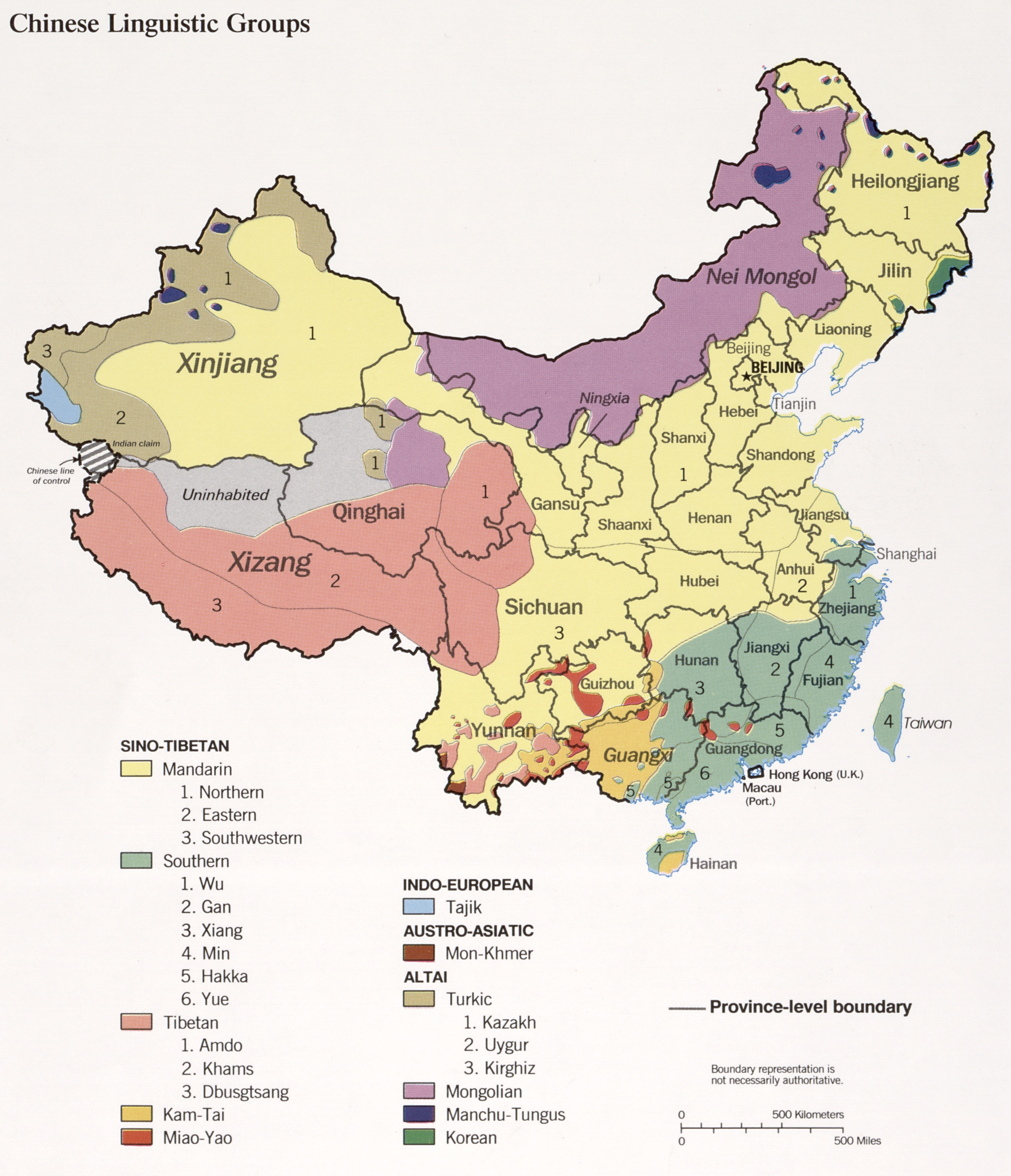
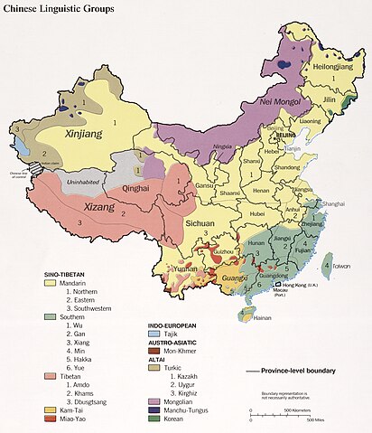
English: Chinese linguistic groups, 1990. The map shows the distribution of linguistic groups in China according to the historical majority ethnic groups by region. Note this does not represent the current distribution due to age-long internal migration and assimilation. |
| Datum | |
| Quelle |
|
| Urheber | U.S. Central Intelligence Agency |
| Andere Versionen |
|


Lizenz[Bearbeiten]
| Dieses Bild ist eine Arbeit eines CIA-Mitarbeiters. Als ein Werk der Regierung der Vereinigten Staaten ist dieses Bild in den USA gemeinfrei.
|

|
Ursprüngliches Datei-Logbuch[Bearbeiten]
Die ursprüngliche Dateibeschreibungsseite war hier. Alle folgenden Benutzernamen beziehen sich auf en.wikipedia.
- 2004-03-02 10:12 Jiang 900×1131× (200611 bytes) Source: Central Intelligence Agency 1990.
Dateiversionen
Klicke auf einen Zeitpunkt, um diese Version zu laden.
| Version vom | Vorschaubild | Maße | Benutzer | Kommentar | |
|---|---|---|---|---|---|
| aktuell | 16:40, 16. Mär. 2023 | | 2.640 × 3.072 (1,85 MB) | RZuo (Diskussion | Beiträge) | lossless crop |
| 16:34, 16. Mär. 2023 |  | 3.300 × 4.362 (2,73 MB) | RZuo (Diskussion | Beiträge) | jpg converted from tiff from https://www.loc.gov/item/90686002/ | |
| 07:37, 5. Mai 2021 |  | 2.538 × 2.844 (2,54 MB) | Glennznl (Diskussion | Beiträge) | Reverted to version as of 22:40, 18 April 2019 (UTC) RV to higher quality version that does not show Aksai Chin as China | |
| 21:29, 1. Sep. 2020 |  | 869 × 964 (178 KB) | RZuo (Diskussion | Beiträge) | Reverted to version as of 14:21, 7 February 2011 (UTC) do not COM:OVERWRITE with a factually different map. the two versions are different. look carefully. | |
| 15:56, 1. Sep. 2020 |  | 2.538 × 2.844 (615 KB) | Glennznl (Diskussion | Beiträge) | Reverted to version as of 16:05, 22 August 2020 (UTC) What is the point of reverting it to a horribly blurry version from 2011? | |
| 19:02, 27. Aug. 2020 |  | 869 × 964 (178 KB) | RZuo (Diskussion | Beiträge) | Reverted to version as of 14:21, 7 February 2011 (UTC) | |
| 16:05, 22. Aug. 2020 |  | 2.538 × 2.844 (615 KB) | Glennznl (Diskussion | Beiträge) | Reverted to version as of 15:49, 19 September 2019 (UTC) | |
| 10:16, 26. Apr. 2020 |  | 869 × 964 (178 KB) | Roy17 (Diskussion | Beiträge) | Reverted to version as of 14:21, 7 February 2011 (UTC) | |
| 15:49, 19. Sep. 2019 |  | 2.538 × 2.844 (615 KB) | Бмхүн (Diskussion | Beiträge) | Reverted to version as of 07:34, 18 April 2019 (UTC) | |
| 21:09, 31. Mai 2019 |  | 2.538 × 2.844 (2,54 MB) | Speravir (Diskussion | Beiträge) | Reverted to version as of 20:06, 11 February 2012 (UTC) |
Du kannst diese Datei nicht überschreiben.
Dateiverwendung
Die folgenden 18 Seiten verwenden diese Datei:
- User:Chumwa/OgreBot/Travel and communication maps/2017 February 1-9
- User:Chumwa/OgreBot/Travel and communication maps/2017 January 21-31
- User:Chumwa/OgreBot/Travel and communication maps/2017 July 1-10
- User:Chumwa/OgreBot/Travel and communication maps/2017 September 21-30
- User:Chumwa/OgreBot/Travel and communication maps/2019 April 11-20
- User:Chumwa/OgreBot/Travel and communication maps/2019 May 21-31
- User:Chumwa/OgreBot/Travel and communication maps/2019 September 11-20
- User:Chumwa/OgreBot/Travel and communication maps/2020 April 21-30
- User:Chumwa/OgreBot/Travel and communication maps/2020 August 21-31
- User:Chumwa/OgreBot/Travel and communication maps/2020 September 1-10
- User:Chumwa/OgreBot/Travel and communication maps/2021 May 1-10
- User:Chumwa/OgreBot/Travel and communication maps/2023 March 11-20
- User:Multila/Favorites
- User:Sanandros/ogre/secret intelligence/2017 February 1-9
- User:Sanandros/ogre/secret intelligence/2017 January 21-31
- File:China linguistic map de.svg
- File:China linguistic map nl.svg
- File:China linguistic map zh.jpg
Globale Dateiverwendung
Die nachfolgenden anderen Wikis verwenden diese Datei:
- Verwendung auf ast.wikipedia.org
- Verwendung auf bcl.wikipedia.org
- Verwendung auf blk.wikipedia.org
- Verwendung auf bn.wikipedia.org
- Verwendung auf bxr.wikipedia.org
- Verwendung auf cs.wikipedia.org
- Verwendung auf dsb.wikipedia.org
- Verwendung auf dv.wikipedia.org
- Verwendung auf en.wikipedia.org
- Verwendung auf es.wikipedia.org
- Verwendung auf fr.wikipedia.org
- Verwendung auf gl.wikipedia.org
- Verwendung auf ha.wikipedia.org
- Verwendung auf hy.wikipedia.org
- Verwendung auf id.wikipedia.org
- Verwendung auf ig.wikipedia.org
- Verwendung auf it.wikipedia.org
- Verwendung auf mk.wikipedia.org
- Verwendung auf mn.wikipedia.org
- Verwendung auf my.wikipedia.org
- Verwendung auf pl.wikipedia.org
- Verwendung auf pnb.wikipedia.org
- Verwendung auf ro.wikipedia.org
- Verwendung auf ro.wiktionary.org
- Verwendung auf ru.wikipedia.org
- Verwendung auf sa.wikipedia.org
- Verwendung auf sc.wikipedia.org
- Verwendung auf sk.wikipedia.org
- Verwendung auf sr.wikipedia.org
- Verwendung auf sw.wikipedia.org
- Verwendung auf ta.wikipedia.org
- Verwendung auf test2.wikipedia.org
- Verwendung auf te.wikipedia.org
- Verwendung auf tl.wikipedia.org
- Verwendung auf tr.wikipedia.org
- Verwendung auf uk.wikipedia.org
- Verwendung auf ur.wikipedia.org
Weitere globale Verwendungen dieser Datei anschauen.