File:Corfu topographic map-en.svg

Fichier d’origine (Fichier SVG, nominalement de 2 096 × 2 341 pixels, taille : 2,19 Mio)
Légendes
Légendes
![]()
Detailed map of large dimension. For a better viewing, click on the link of the image above.
Carte détaillée de grande dimension. Pour une visualisation optimale, cliquer sur le lien de l'image ci-dessus.
Description
[modifier]| Description |
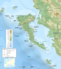
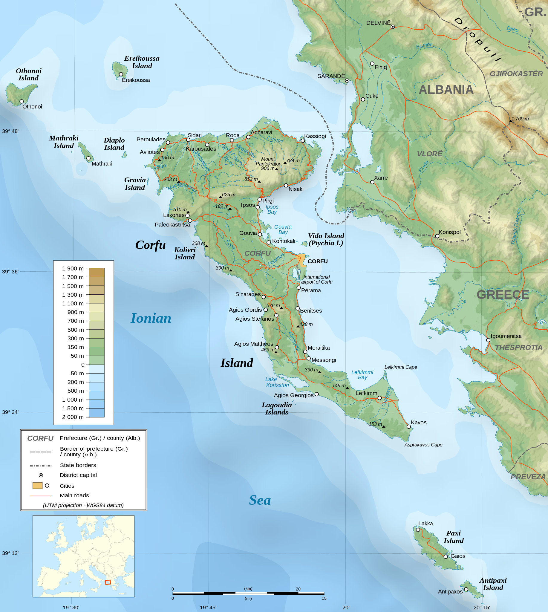
English: Topographic map in English of the Corfu island area in Greece.
Note : The shaded relief is a raster image embedded in the SVG file. Français : Carte topographique en anglais de la zone de l'île de Corfou en Grèce.
Note : Le relief ombré est une image bitmap embarquée dans le fichier SVG. UTM projection ; WGS84 datum ; shaded relief (composite image of N-W, W and N lightning positions) ;
|
||
| SVG information | Le code de ce fichier SVG n'est pas valide en raison de 2 erreurs. Cette carte SVG utilise du texte encapsulé qui peut être traduit facilement à l'aide d'un éditeur de texte. |
||
| Date | March 2007 (modified 09/2008) | ||
| Source |
Own work ;
|
||
| Créé par | |||
| Autorisation (Réutilisation de ce fichier) |
|
||
| Géoréférencement | Si c'est inapproprié, définissez warp_status = skip pour masquer. | ||
| Autres versions |
[]
|


Conditions d’utilisation
[modifier]
|
Vous avez la permission de copier, distribuer et modifier ce document selon les termes de la GNU Free Documentation License version 1.2 ou toute version ultérieure publiée par la Free Software Foundation, sans sections inaltérables, sans texte de première page de couverture et sans texte de dernière page de couverture. Un exemplaire de la licence est inclus dans la section intitulée GNU Free Documentation License. |
| Ce fichier est disponible selon les termes de la licence Creative Commons Attribution – Partage dans les Mêmes Conditions 3.0 (non transposée). | ||
| ||
| Ce bandeau de licence a été ajouté à ce fichier dans le cadre de la procédure de mise à jour des licences des images sous GFDL. |
- Vous êtes libre :
- de partager – de copier, distribuer et transmettre cette œuvre
- d’adapter – de modifier cette œuvre
- Sous les conditions suivantes :
- paternité – Vous devez donner les informations appropriées concernant l'auteur, fournir un lien vers la licence et indiquer si des modifications ont été faites. Vous pouvez faire cela par tout moyen raisonnable, mais en aucune façon suggérant que l’auteur vous soutient ou approuve l’utilisation que vous en faites.
- partage à l’identique – Si vous modifiez, transformez, ou vous basez sur cette œuvre, vous devez distribuer votre contribution sous la même licence ou une licence compatible avec celle de l’original.
Distinctions
[modifier]
|

Historique du fichier
Cliquer sur une date et heure pour voir le fichier tel qu'il était à ce moment-là.
| Date et heure | Vignette | Dimensions | Utilisateur | Commentaire | |
|---|---|---|---|---|---|
| actuel | 24 août 2021 à 07:17 | | 2 096 × 2 341 (2,19 Mio) | Praça de Maio (d | contributions) | File uploaded using svgtranslate tool (https://svgtranslate.toolforge.org/). Added translation for tr. |
| 29 octobre 2014 à 22:47 |  | 2 096 × 2 341 (2,18 Mio) | Ras67 (d | contributions) | cropped | |
| 4 septembre 2008 à 22:41 |  | 2 100 × 2 345 (2,47 Mio) | Sting (d | contributions) | Using bathymetry from ETOPO1 ; new standard colors | |
| 29 octobre 2007 à 18:59 |  | 2 100 × 2 345 (3,17 Mio) | Sting (d | contributions) | "Pavllo" river name correction ; + river names on Corfu island ; key more complete | |
| 16 mai 2007 à 01:05 |  | 2 100 × 2 345 (3,14 Mio) | Sting (d | contributions) | International elevation key | |
| 30 mars 2007 à 01:07 |  | 2 100 × 2 345 (3,14 Mio) | Sting (d | contributions) | {{Information| |Description=Topographic map in French of the Corfu island area in Greece. |Source=Own work ;<br/>Background map : [http://www2.jpl.nasa.gov/srtm NASA Shuttle Radar Topography Mission] (SRTM3 v.2) (public domain) edited with [ |
Vous ne pouvez pas remplacer ce fichier.
Utilisations locales du fichier
Les 57 pages suivantes utilisent ce fichier :
- Wikimedia Conference Japan 2009/Commons写真展
- User:Aristeas/check
- User:Giorgi Balakhadze/Gallery
- User:JoKalliauer/SVG test suites/Featured details
- User:Magog the Ogre/Multilingual legend/2021 August 21-31
- User:Miya/Introduction
- User:Pfctdayelise/POTY07 categories/2007 list
- User:SVGbot/Results
- User:Sting/Gallery: Regional maps
- User:Sting/Profile
- User talk:MapMaster
- User talk:Sting/Archive 01
- Commons:Bu proje sayfasının diğer dil sürümleri
- Commons:Conhece os nossos ilustradores
- Commons:Conoce a nuestros ilustradores
- Commons:Descobreix els nostres il.lustradors
- Commons:Descobrètz nòstres illustrators
- Commons:Découvrez nos illustrateurs
- Commons:Featured picture candidates/Image:Corfu topographic map-en.svg
- Commons:Featured picture candidates/Log/November 2007
- Commons:Featured pictures/Non-photographic media/Maps
- Commons:Featured pictures/chronological/2007-B
- Commons:Graphic Lab/Map workshop/Archive/2014
- Commons:Meet our illustrators
- Commons:Meet our illustrators/People
- Commons:Picture of the Year/2007/Galleries/All
- Commons:Picture of the Year/2007/Galleries/Graphic art and maps
- Commons:Picture of the Year/2007/Results/Round 1/Gallery
- Commons:Poznaj naszych grafików
- Commons:Scopri i nostri illustratori
- Commons:Scummigghia ê nostri llustratura
- Commons:Unsere Illustratoren stellen sich vor
- Commons:Unseri Illustratore stelle sich vor
- Commons:Upoznajte naše ilustratore
- Commons:Çizerlerimizle tanışın
- Commons:Запознајте ги нашите илустратори
- Commons:Знайомтесь з нашими ілюстраторами
- Commons:Знакомьтесь с нашими иллюстраторами
- Commons:قابل رسامينا
- Commons:私達のイラストレータをご紹介します
- Commons:结识我们的插图师
- Commons:우리들의 삽화가를 만나보세요
- Commons talk:Project Mapmaking Wiki Standards/Archive01
- File:Corfu topographic map-Stad.PNG
- File:Corfu topographic map-be.svg
- File:Corfu topographic map-blank.svg
- File:Corfu topographic map-de.svg
- File:Corfu topographic map-el.svg
- File:Corfu topographic map-en.svg
- File:Corfu topographic map-en librsvg.png
- File:Corfu topographic map-en rendersvg.png
- File:Corfu topographic map-es.svg
- File:Corfu topographic map-fr.svg
- File:Corfu topographic map-hu.svg
- File:Corfu topographic map-mk.svg
- File:Corfu topographic map-nb.svg
- Template:Other versions/Corfu topographic map
Utilisations du fichier sur d’autres wikis
Les autres wikis suivants utilisent ce fichier :
- Utilisation sur af.wikipedia.org
- Utilisation sur bg.wikipedia.org
- Utilisation sur bn.wikipedia.org
- Utilisation sur bs.wikipedia.org
- Utilisation sur ca.wikipedia.org
- Utilisation sur de.wikipedia.org
- Utilisation sur en.wikipedia.org
- Utilisation sur en.wikiquote.org
- Utilisation sur es.wikipedia.org
- Utilisation sur fa.wikipedia.org
- Utilisation sur fi.wikipedia.org
- Utilisation sur fr.wikipedia.org
- Utilisation sur fy.wikipedia.org
- Utilisation sur gl.wikipedia.org
- Utilisation sur he.wikipedia.org
- Utilisation sur hu.wikipedia.org
- Utilisation sur hy.wikipedia.org
- Utilisation sur ia.wikipedia.org
- Utilisation sur id.wikipedia.org
- Utilisation sur is.wikipedia.org
- Utilisation sur it.wikipedia.org
- Utilisation sur it.wikivoyage.org
- Utilisation sur ja.wikipedia.org
Voir davantage sur l’utilisation globale de ce fichier.