File:Curonian Spit NP 05-2017 img17 aerial view at Epha Dune.jpg
跳转到导航
跳转到搜索

本预览的尺寸:800 × 500像素。 其他分辨率:320 × 200像素 | 640 × 400像素 | 1,024 × 640像素 | 1,280 × 800像素 | 2,560 × 1,600像素 | 4,213 × 2,633像素。
原始文件 (4,213 × 2,633像素,文件大小:7.93 MB,MIME类型:image/jpeg)
说明
说明
添加一行文字以描述该文件所表现的内容
Curonian Spit in Kaliningrad Oblast, Russia
| 描述 |
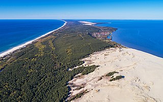
English: Curonian Spit in Kaliningrad Oblast (Russia). Aerial view over Epha Dune.
Deutsch: Kurische Nehrung im Kaliningrader Gebiet (Russland). Luftaufnahme über der Epha-Düne.
Polski: Mierzeja Kurońska położona w obwodzie kaliningradzkim, w Rosji. Widok z powietrza znad wydmy Epha.
Русский: Куршская коса в Калининградской области (Россия). Аэрофотосъёмка над дюной Эфа.
Čeština: Letecký snímek části písečného poloostrova Kurská kosa v Baltském moři v Kaliningradské oblasti, Rusko.
|
|||
| 日期 | ||||
| 来源 | 自己的作品 | |||
| 作者 | A.Savin | |||
| 授权 (二次使用本文件) |
.svg) Just attribute the author: «A.Savin, Wikipedia»; if you have questions — Telegram, or e-mail to wikiphotospace@gmail.com..svg) Просто укажите в качестве автора: «А.Савин, Википедия»; если есть вопрос — телеграм, или эл.почта на wikiphotospace@gmail.com. Kennzeichnen Sie einfach als Autor: «A.Savin, Wikipedia»; falls Sie Fragen haben — Telegram, oder E-Mail an wikiphotospace@gmail.com.
Thank you. |
| 相机位置 | | 在以下服务上查看本图像和附近其他图像: OpenStreetMap |
|---|
此图像是维基爱地球 2017的一个图像。
|
 |
This image was selected as picture of the day on Wikimedia Commons for 18 March 2019. It was captioned as follows: Other languages:
Čeština: Letecký snímek části písečného poloostrova Kurská kosa v Baltském moři v Kaliningradské oblasti, Rusko. Deutsch: Luftaufnahme der Kurischen Nehrung mit dem Nationalpark (heute Oblast Kaliningrad in Russland, früher das nördliche Ostpreußen). Rechts das Kurische Haff, links die Ostsee. Polski: Widok z lotu ptaka na Park Narodowy Mierzei Kurońskiej położony w obwodzie kaliningradzkim, w Rosji. |
许可协议
[编辑]
| 非营利著作权:本艺术作品是自由的,您可以依据自由艺术作品许可协议的条款传播和/或修改本艺术作品。您可以在Copyleft Attitude网站或其他网站找到该许可协议的样本。 |
文件历史
点击某个日期/时间查看对应时刻的文件。
| 日期/时间 | 缩略图 | 大小 | 用户 | 备注 | |
|---|---|---|---|---|---|
| 当前 | 2017年5月22日 (一) 18:07 | | 4,213 × 2,633(7.93 MB) | A.Savin(留言 | 贡献) | {{User:A.Savin/F |Description= {{en|Curonian Spit in Kaliningrad Oblast (Russia). Aerial view over Epha Dune.}} {{de|Kurische Nehrung im Kaliningrader Gebiet (Russland). Luftaufnahme über der Epha-Düne.}} {{ru|Куршская коса в Калин... |
您不可以覆盖此文件。
文件用途
以下26个页面使用本文件:
- User:A.Savin/Archive/2017/3
- Commons:Featured picture candidates/File:Curonian Spit NP 05-2017 img17 aerial view at Epha Dune.jpg
- Commons:Featured picture candidates/Log/September 2017
- Commons:Featured pictures/Places/Natural/Russia
- Commons:Featured pictures/chronological/2017-B
- Commons:Picture of the Year/2017/Candidates
- Commons:Picture of the Year/2017/R1/Gallery/2017-B
- Commons:Picture of the Year/2017/R1/Gallery/ALL
- Commons:Picture of the Year/2017/R1/Gallery/M09
- Commons:Picture of the Year/2017/R1/Gallery/Nature views
- Commons:Picture of the Year/2017/R1/v/Curonian Spit NP 05-2017 img17 aerial view at Epha Dune.jpg
- Commons:WikiProject Aviation/recent uploads/2017 May 22
- Template:Potd/2019-03
- Template:Potd/2019-03-18
- Template:Potd/2019-03-18 (cs)
- Template:Potd/2019-03-18 (de)
- Template:Potd/2019-03-18 (en)
- Template:Potd/2019-03-18 (es)
- Template:Potd/2019-03-18 (hu)
- Template:Potd/2019-03-18 (mk)
- Template:Potd/2019-03-18 (nl)
- Template:Potd/2019-03-18 (pl)
- Template:Potd/2019-03-18 (pt)
- Template:Potd/2019-03-18 (pt-br)
- Template:Potd/2019-03-18 (ru)
- Category:Curonian Spit
全域文件用途
以下其他wiki使用此文件:
- ar.wikipedia.org上的用途
- ba.wikipedia.org上的用途
- be-tarask.wikipedia.org上的用途
- ca.wikipedia.org上的用途
- crh.wikipedia.org上的用途
- cs.wikipedia.org上的用途
- cv.wikipedia.org上的用途
- de.wikipedia.org上的用途
- en.wikipedia.org上的用途
- en.wikivoyage.org上的用途
- en.wiktionary.org上的用途
- eo.wikipedia.org上的用途
- es.wikipedia.org上的用途
- fi.wikipedia.org上的用途
- frr.wikipedia.org上的用途
- fr.wikipedia.org上的用途
- Parc national de l'Isthme de Courlande (Lituanie)
- Liste des parcs nationaux de Russie
- Wikipédia:Image du jour/13 octobre 2017
- Wikipédia:Image du jour/octobre 2017
- Projet:Aide et accueil/Twitter/Tweets/archives/octobre 2017
- Portail:Désert/Index thématique
- Portail:Désert
- Portail:Oblast de Kaliningrad
- Raïon de Zelenogradsk
- hr.wikipedia.org上的用途
- hsb.wikipedia.org上的用途
- hu.wikipedia.org上的用途
- hy.wikipedia.org上的用途
- it.wikipedia.org上的用途
- it.wikivoyage.org上的用途
- it.wiktionary.org上的用途
- ka.wikipedia.org上的用途
查看此文件的更多全域用途。