File:Dasht-e Kavir.jpg
Archivo original (5822 × 5820 píxeles; tamaño de archivo: 3,5 MB; tipo MIME: image/jpeg)
Leyendas
Leyendas
Resumen[editar]
| Descripción |
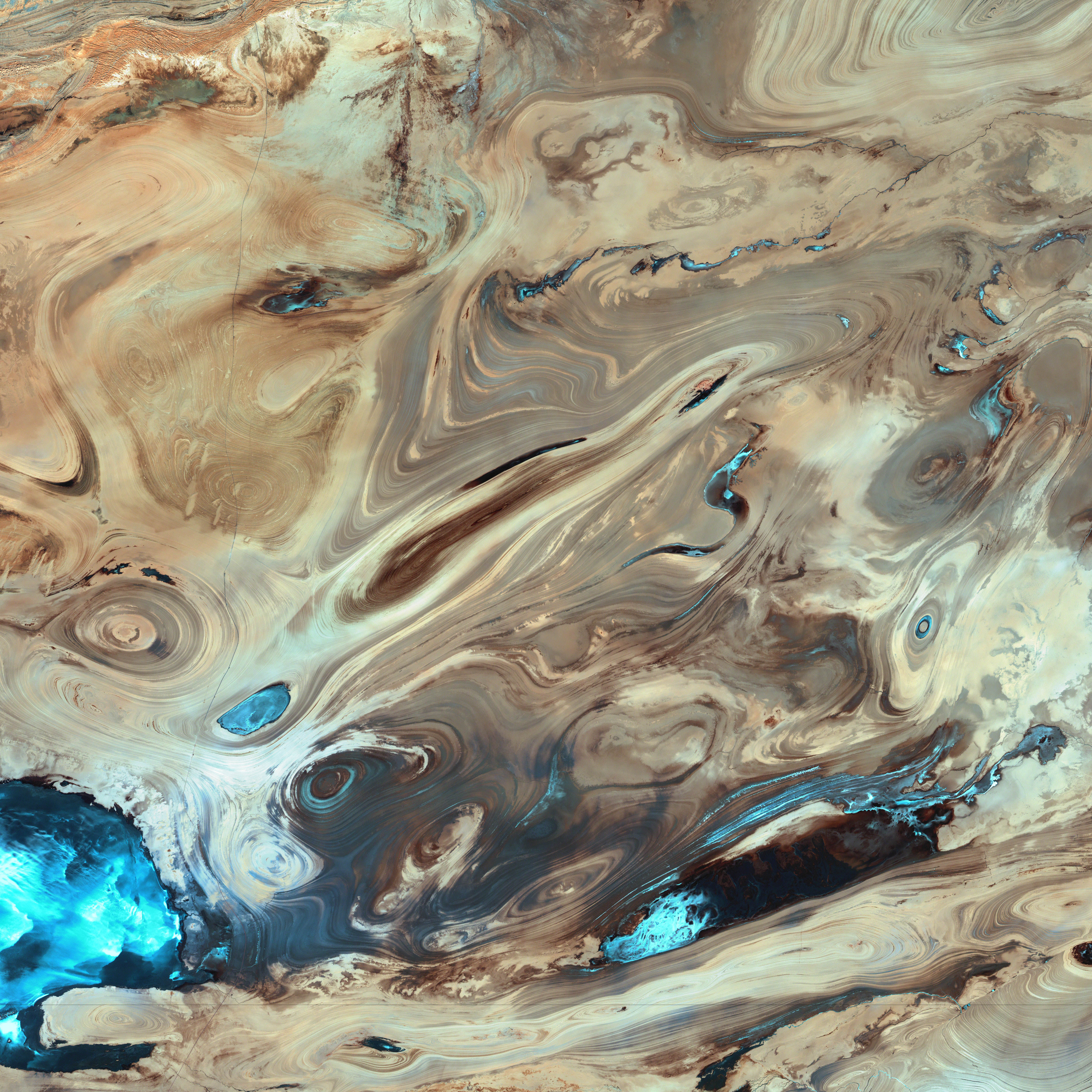
English: A satellite picture of the Dasht-e Kavir desert in Iran.
The patterns you see are formed by different geological layers that have been eroded over thousands of years by wind and sometimes (but not often) rain. The patterns are formed from either horizontal geological layers cut through by topographic changes, or geological formations (folds, domes, etc) in relatively flat terrain. Most of the colours are due to chemical differences in the rocks, whilst the intense blue colours could be due to a range of materials, possibly salt deposits, possibly vegetation, depending on which area of the EM spectrum is represented by blue. I suspect (but don't know, the satellite bands to displayed colours are not mentioned) that the blue colours are salt deposits, but they could equally be other materials too. To be certain, knowledge of the bands to display colours is essential. The black line running horizontally across the image is a sensor drop-out and the data for that line or lines has been irrevocably lost. The linear (but not straight) line running vertically down the middle left is a road. USGS/NASA description: The Dasht-e Kevir, or Great Salt Desert, is the largest desert in Iran. It is primarily uninhabited wasteland, composed of mud and salt marshes covered with crusts of salt that protect the meager moisture from completely evaporating. This image was acquired by Landsat 7’s Enhanced Thematic Mapper plus (ETM+) sensor on October 24, 2000. This is a false-color composite image made using infrared, green, and red wavelengths. The image has also been sharpened using the sensor’s panchromatic band.فارسی: تصویر ماهوارهای از دشت کویر ایران. اکثر رنگهای موجود در نگاره و تفاوتهای شیدهای مختلف، به دلایل اختلافهای ترکیبات شیمیایی مواد تشکیل دهنده صخرهها و تپهها است که در کنار یکدیگر جلوهگر شدهاند. رنگهای تند آبی احتمالاً ناشی از رسوب نمکهای باقی مانده از رستنیها و گیاهان کویری است. البته این استنتاج بستگی مستقیم به طیف الکترومغناطیسی دارد که با رنگ آبی نمایش داده شدهاست. |
| Fecha | |
| Fuente | NASA Earth Observatory. |
| Autor | USGS EROS Data Center Satellite Systems Branch. |
| Ubicación del objeto | | Ubicación de esta y otras imágenes en: OpenStreetMap |
|---|
(centre of image)
Licencia[editar]
| Este archivo es de dominio público porque fue creado por la NASA. Las políticas sobre copyright de la NASA estipulan que «el material de la NASA no está protegido con copyright a menos que se indique lo contrario». (Políticas sobre copyright de la NASA o Políticas sobre la utilización de imágenes del Jet Propulsion Laboratory). | ||
 |
Advertencias:
|
Esta imagen está en el dominio público, ya que contiene materiales que originalmente vinieron del Servicio Geológico de los Estados Unidos de América, una agencia del Departamento del Interior. Para obtener más información, consulte la política oficial de derechos de los USGS.
|
|
| Annotations | This image is annotated: View the annotations at Commons |
Historial del archivo
Haz clic sobre una fecha y hora para ver el archivo tal como apareció en ese momento.
| Fecha y hora | Miniatura | Dimensiones | Usuario | Comentario | |
|---|---|---|---|---|---|
| actual | 20:39 18 ene 2006 | | 5822 × 5820 (3,5 MB) | David.Monniaux (discusión | contribs.) | ran it through jpegtran to output optimized, non-progressive jpeg |
| 20:09 18 ene 2006 |  | 5822 × 5820 (3,66 MB) | Palladinus (discusión | contribs.) | Dasht-e Kavir desert in Iran |
No puedes sobrescribir este archivo.
Usos del archivo
Las siguientes páginas usan este archivo:
- Featured Photographs in the Public Domain
- ایران
- User:Hartwin Wolf/Gallery:miscellany
- User:Mattes/Parking
- User talk:Peter23
- Commons:Featured picture candidates/File:Dasht-e Kavir.jpg
- Commons:Featured picture candidates/Image:Dasht-e Kavir.jpg
- Commons:Featured picture candidates/Log/August 2007
- Commons:Featured picture candidates/Log/November 2012
- Commons:Featured pictures/Places/Satellite images
- Commons:Featured pictures/chronological/2012-B
- Commons:Picture of the Year/2012/Galleries/2012-B
- Commons:Picture of the Year/2012/Galleries/ALL
- Commons:Picture of the Year/2012/Galleries/Astronomy
- Commons:Picture of the Year/2012/Galleries/Index/16
- Commons:Picture of the Year/2012/Galleries/NOV
- Commons:Picture of the Year/2012/R1/Dasht-e Kavir.jpg
- Commons:Picture of the Year/2012/Results/R1/ALL
- Commons:Picture of the Year/2012/Results/R1/ALL/gallery
- Commons:Picture of the Year/2012/Results/R1/ALL/thumbnailtable
- Commons:Picture of the Year/2012/Results/R1/Astronomy
- Commons talk:Picture of the Year/2012
Uso global del archivo
Las wikis siguientes utilizan este archivo:
- Uso en als.wikipedia.org
- Uso en ar.wikipedia.org
- Uso en azb.wikipedia.org
- Uso en az.wikipedia.org
- Uso en be.wikipedia.org
- Uso en bg.wikipedia.org
- Uso en bs.wikipedia.org
- Uso en ca.wikipedia.org
- Uso en cs.wikipedia.org
- Uso en de.wikipedia.org
- Uso en en.wikipedia.org
- Uso en es.wikipedia.org
- Uso en es.wikibooks.org
- Uso en es.wikisource.org
- Uso en et.wikipedia.org
- Uso en eu.wikipedia.org
- Uso en fa.wikipedia.org
- دشت کویر
- ویکیپدیا:انتخاب نگاره هفته/سال ۲۰۱۱/هفته ۱
- ویکیپدیا:انتخاب نگاره هفته/سال ۲۰۱۱/هفته ۱/کویر مرکزی ایران
- ویکیپدیا:نگارههای برگزیده/پدیدههای طبیعی
- ویکیپدیا:نگارههای برگزیده/علمی/زمینشناسی
- ویکیپدیا:گزیدن نگاره برگزیده/فوریه-۲۰۱۲
- ویکیپدیا:نگاره روز/ژوئن ۲۰۱۲
- ویکیپدیا:گزیدن نگاره برگزیده/Dasht-e Kavir.jpg
- الگو:نر/2012-06-21
- الگو:نر محافظت شده/2012-06-21
- بحث کاربر:Alborzagros/بایگانی ۵
- درگاه:علوم زمین/نگاره برگزیده/۲
- درگاه:علوم زمین/نگاره برگزیده
- تصویربرداری ماهوارهای
- Uso en fr.wikipedia.org
- Uso en gd.wikipedia.org
- Uso en gl.wikipedia.org
- Uso en hr.wikipedia.org
- Uso en id.wikipedia.org
Ver más uso global de este archivo.