File:De la Punta de Araya y su fondeadero, parte de la costa del E., parte del Golfo de Cariaco, Bahía de Cumana (cituado su castillo segun observzs. astronómicas en la lattd. nte. de 10 gs. 28 ms.), costa LOC 90682952.tif
Jump to navigation
Jump to search

Size of this JPG preview of this TIF file: 757 × 600 pixels. Other resolutions: 303 × 240 pixels | 606 × 480 pixels | 969 × 768 pixels | 1,280 × 1,014 pixels | 2,560 × 2,028 pixels | 6,193 × 4,907 pixels.
Original file (6,193 × 4,907 pixels, file size: 86.94 MB, MIME type: image/tiff)
Captions
Captions
Add a one-line explanation of what this file represents
Summary
[edit]| Description |
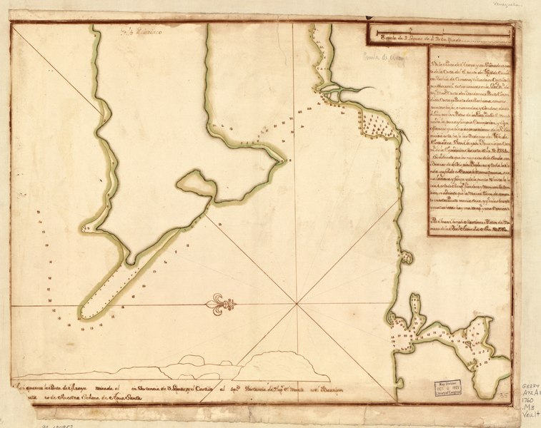
English: Shows coast of Venezuela in the region of Araya. Depths shown by soundings. Oriented with north toward the lower left. Watermarks: IV; and, fleur-de-lis. Pen-and-ink and watercolor. Mounted on cloth backing. LC Luso-Hispanic World, 982 Available also through the Library of Congress Web site as a raster image. Includes note and view. Maggs number annotated in pencil in lower right corner: 35. Vault |
||
| Title | De la Punta de Araya y su fondeadero, parte de la costa del E., parte del Golfo de Cariaco, Bahía de Cumana (cituado su castillo segun observzs. astronómicas en la lattd. nte. de 10 gs. 28 ms.), costa de Bordones, Puerto Escondido, costa y puerto de Mochima con sus puntas, bajos, ensenadas y sondas, dado a luz por los pilotos de la Fragta. de S.M. nombrada la Pura y Limpia, concepción y San Marcos que bino a operaciones del Rl. Servicio a esta bajo las ordenes del Gefe de Esquadra Don Joseph Yturriaga, commte. de la espedición secreta, año de 1754 | ||
| Shelf ID | G5284.A72A1 1760 .M3 | ||
| Date | |||
| Source | https://www.loc.gov/item/90682952/ | ||
| Author | Martínez, Juan Joseph | ||
| Permission (Reusing this file) |
|
||
| Other versions |
|
||
| Location | Atlantic Coast · Venezuela · Araya Region | ||
| Part of | American Memory · Catalog · Geography And Map Division · Cultural Landscapes | ||
| Subject | Maps, Manuscript · Araya Region (Venezuela) · Coasts · Araya Region · Atlantic Coast (Venezuela) · Maps · Early Works To 1800 · Atlantic Coast · Venezuela · Manuscript Maps |

,_costa_LOC_90682952.jpg)
Licensing
[edit]|
This is a faithful photographic reproduction of a two-dimensional, public domain work of art. The work of art itself is in the public domain for the following reason:
The official position taken by the Wikimedia Foundation is that "faithful reproductions of two-dimensional public domain works of art are public domain".
This photographic reproduction is therefore also considered to be in the public domain in the United States. In other jurisdictions, re-use of this content may be restricted; see Reuse of PD-Art photographs for details. | ||||
File history
Click on a date/time to view the file as it appeared at that time.
| Date/Time | Thumbnail | Dimensions | User | Comment | |
|---|---|---|---|---|---|
| current | 07:16, 23 May 2018 |  | 6,193 × 4,907 (86.94 MB) | Fæ (talk | contribs) | LOC Maps https://www.loc.gov/item/90682952/ #13632 |
You cannot overwrite this file.
File usage on Commons
The following page uses this file: