File:Europe 1914 Shepherd.jpg
Rozmiar pierwotny (1789 × 1465 pikseli, rozmiar pliku: 3,78 MB, typ MIME: image/jpeg)
Podpisy
Podpisy
Opis[edytuj]
| Opis |
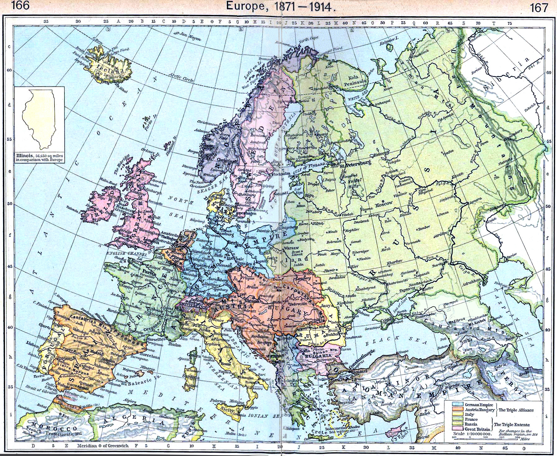
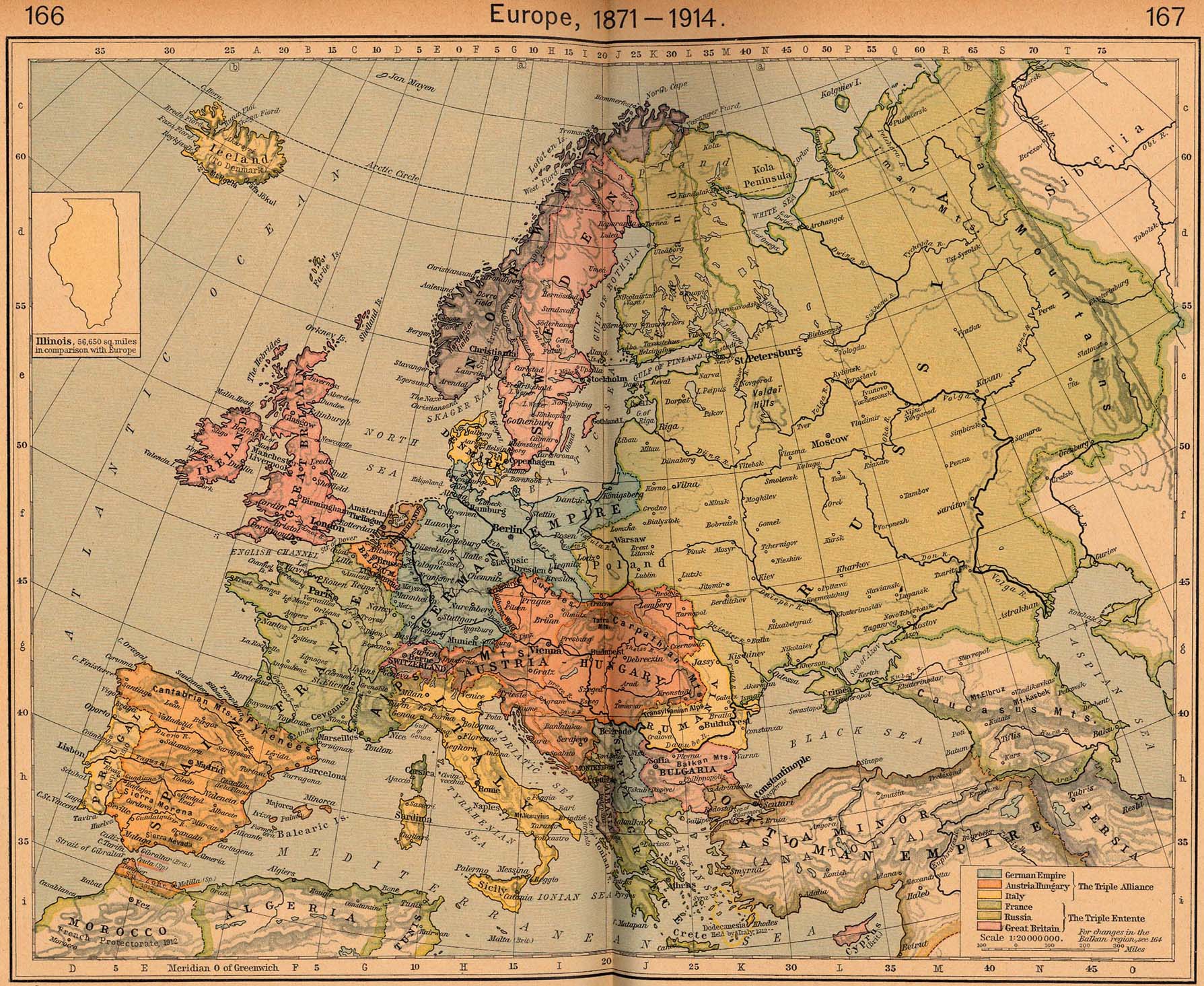
English: Map of Europe in 1914 |
||||||||||||||||||||||
| Data | |||||||||||||||||||||||
| Źródło | http://www.lib.utexas.edu/maps/historical/shepherd/europe_1871_1914.jpg | ||||||||||||||||||||||
| Autor |
|
||||||||||||||||||||||
This is from the 1926 edition of the "Historical Atlas" by William R. Shepherd published by the Henry Holt and Company, New York. It may have been first published earlier in previous editions. The image is from the University of Texas Perry-Castañeda Library Map Collection.
Licencja[edytuj]
|
Ten materiał przeszedł do domeny publicznej w kraju pochodzenia, jak również w państwach i terytoriach, gdzie prawo autorskie wygasa w ciągu 70 lat po śmierci autora.
| |
| Plik rozpoznano jako wolny od znanych ograniczeń praw autorskich, włącznie z prawami zależnymi i pokrewnymi. | |
_en.png)
.png)
.jpg)
Historia pliku
Kliknij na odpowiedniej dacie/czasie, aby zobaczyć wersję pliku z tamtego okresu.
| Data/czas | Miniatura | Wymiary | Użytkownik | Opis | |
|---|---|---|---|---|---|
| aktualny | 12:15, 20 wrz 2022 | | 1789 × 1465 (3,78 MB) | Рагин1987 (dyskusja | edycje) | Small correction |
| 09:17, 21 mar 2012 |  | 1789 × 1465 (2,73 MB) | Phoenix7777 (dyskusja | edycje) | Reduced creases | |
| 13:55, 20 mar 2012 |  | 1789 × 1465 (2,85 MB) | 1Veertje (dyskusja | edycje) | more exposure on the fold | |
| 00:48, 23 lut 2011 |  | 1789 × 1465 (2,84 MB) | Pearts (dyskusja | edycje) | sides lined up, page bends made a little less visible, vibrance reduced a little | |
| 16:26, 3 paź 2010 |  | 1789 × 1465 (1,39 MB) | PawełMM (dyskusja | edycje) | flattened & whitened | |
| 14:49, 6 lip 2010 |  | 1789 × 1465 (623 KB) | Yebellz (dyskusja | edycje) | Whitened Version | |
| 14:41, 6 lip 2010 |  | 1789 × 1465 (604 KB) | Yebellz (dyskusja | edycje) | {{Information |Description={{en|1=Map of Europe in 1914}} |Source=http://www.lib.utexas.edu/maps/historical/shepherd/europe_1871_1914.jpg |Author=William R. Shepherd |Date=1926 |Permission= |other_versions= }} This is from the 1926 edition of the "Histori |
Nie możesz nadpisać tego pliku.
Lokalne wykorzystanie pliku
Następujące strony korzystają z tego pliku:
Globalne wykorzystanie pliku
Ten plik jest wykorzystywany także w innych projektach wiki:
- Wykorzystanie na en.wikipedia.org
- Wykorzystanie na hu.wikipedia.org
- Wykorzystanie na hy.wikipedia.org
- Wykorzystanie na nl.wikipedia.org
- Wykorzystanie na pl.wikipedia.org
- Wykorzystanie na pt.wikipedia.org
- Wykorzystanie na ru.wikipedia.org