File:Europe map 1648.PNG

Fitxer original (1.894 × 1.367 píxels, mida del fitxer: 195 Ko, tipus MIME: image/png)
Llegendes
Llegendes

|
Aquesta imatge (de tipus historical map) s'hauria de tornar a crear utilitzant gràfics vectorials com ara un fitxer SVG. Això té diversos avantatges; en trobareu més informació a Commons:Media for cleanup. Si ja disposeu d'una versió d'aquesta imatge en format SVG, us preguem que la pengeu; després, reemplaceu aquesta plantilla amb la plantilla {{Vector version available|nom nou de la imatge.svg}} en aquesta imatge.
|
Resum[modifica]
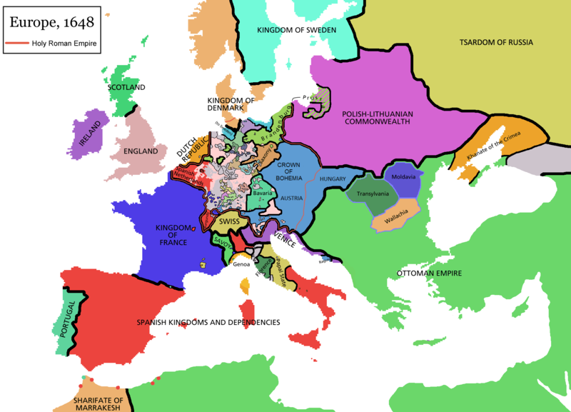
Map of Europe in 1648 (at the end of the Thirty Years War), based on free map of europe Image:BlankMap-Europe.png. Red line marks the border of the Holy Roman Empire. Information from Penguin atlas of modern history. (what year?)
Llicència[modifica]

|
S'autoritza la còpia, la distribució i la modificació d'aquest document sota els termes de la llicència de documentació lliure GNU versió 1.2 o qualsevol altra versió posterior que publiqui la Free Software Foundation; sense seccions invariants, ni textos de portada, ni textos de contraportada. S'inclou una còpia d'aquesta llicència en la secció titulada GNU Free Documentation License.http://www.gnu.org/copyleft/fdl.htmlGFDLGNU Free Documentation Licensetruetrue |
| Aquest fitxer està subjecte a la llicència de Creative Commons Reconeixement i Compartir Igual 3.0 No adaptada. | ||
| ||
| Aquest avís de llicència s'ha afegit a aquest fitxer d'acord amb l'actualització de la llicència GFDL.http://creativecommons.org/licenses/by-sa/3.0/CC BY-SA 3.0Creative Commons Attribution-Share Alike 3.0truetrue |
derivative works[modifica]
Derivative works of this file:
Historial del fitxer
Cliqueu una data/hora per veure el fitxer tal com era aleshores.
| Data/hora | Miniatura | Dimensions | Usuari/a | Comentari | |
|---|---|---|---|---|---|
| actual | 09:44, 14 abr 2021 |  | 1.894 × 1.367 (195 Ko) | Tenan (discussió | contribucions) | Reverted to version as of 16:09, 12 October 2017 (UTC) See discussion |
| 10:47, 9 març 2021 |  | 1.894 × 1.367 (210 Ko) | TTBCamh (discussió | contribucions) | Reverted to version as of 17:18, 20 September 2018 (UTC). I don't know why Raderich is saying this is an arbitrary change—Catalonia was under the possession of the French king in 1648, following the Catalan Revolt of 1640. This map is correct and the previous one is incorrect. | |
| 12:12, 25 set 2018 |  | 1.894 × 1.367 (195 Ko) | Raderich (discussió | contribucions) | Reverted to version as of 21:15, 18 September 2018 (UTC) Undone arbitrary changes. Revert to correct map as uploaded by its creator Roke~commonswiki | |
| 17:18, 20 set 2018 |  | 1.894 × 1.367 (210 Ko) | AmbroiseL (discussió | contribucions) | The Catalan counties were French since they proclaimed Louis XIV of France as their king. They wanted to be French in order not to obey the king of Spain anymore. Courland was a quite free vassal state of Poland. The reverted version doesn't show it. The reverted version also doesn't show the Venetian islands in the Adriatic Sea, and the Algerian towns that France occupied. Hence, I re-revert to the more precise version. | |
| 21:15, 18 set 2018 |  | 1.894 × 1.367 (195 Ko) | Raderich (discussió | contribucions) | Reverted to version as of 16:09, 12 October 2017 (UTC) | |
| 10:45, 19 jul 2018 |  | 1.894 × 1.367 (210 Ko) | AmbroiseL (discussió | contribucions) | Reverted to version as of 12:06, 20 January 2017 (UTC) — reverted to the version with fixed names, my mistake | |
| 10:37, 19 jul 2018 |  | 1.894 × 1.367 (150 Ko) | AmbroiseL (discussió | contribucions) | Reverted to version as of 10:33, 24 September 2016 (UTC) | |
| 16:09, 12 oct 2017 |  | 1.894 × 1.367 (195 Ko) | 力 (discussió | contribucions) | Reverted to version as of 12:42, 9 September 2016 (UTC) why is Catalonia French? Not shown as such on File:Europe_1648_westphal_1884.jpg | |
| 12:06, 20 gen 2017 |  | 1.894 × 1.367 (210 Ko) | Fakirbakir (discussió | contribucions) | Names of Austria, Bohemia and Hungary are fixed. | |
| 10:33, 24 set 2016 |  | 1.894 × 1.367 (150 Ko) | AmbroiseL (discussió | contribucions) | Adjunction of polish-lithuanian vassal state of Courland |
No podeu sobreescriure aquest fitxer.
Ús del fitxer
Les 10 pàgines següents utilitzen aquest fitxer:
Ús global del fitxer
Utilització d'aquest fitxer en altres wikis:
- Utilització a als.wikipedia.org
- Utilització a an.wikipedia.org
- Utilització a ar.wikipedia.org
- Utilització a ast.wikipedia.org
- Utilització a azb.wikipedia.org
- Utilització a bat-smg.wikipedia.org
- Utilització a bg.wikipedia.org
- Utilització a bn.wikipedia.org
- Utilització a br.wikipedia.org
- Utilització a bs.wikipedia.org
- Utilització a ca.wikipedia.org
- Sacre Imperi Romanogermànic
- Dinastia dels Habsburg
- Història d'Europa
- Lluís XIV de França
- Guerra dels Trenta Anys
- Pau de Westfàlia
- Leopold I del Sacre Imperi Romanogermànic
- Guerra dels Vuitanta Anys
- Neollatí
- Antic Règim
- Tractat de Karlowitz
- Setge de Viena (1683)
- Guerra franco-espanyola (1635-1659)
- Gran Guerra Turca
- Utilització a cs.wikipedia.org
- Utilització a cy.wikipedia.org
- Utilització a da.wikipedia.org
- Utilització a de.wikipedia.org
- Utilització a de.wikibooks.org
- Utilització a el.wikipedia.org
- Utilització a en.wikipedia.org
Vegeu més usos globals d'aquest fitxer.
Metadades
Aquest fitxer conté informació addicional, probablement afegida per la càmera digital o l'escàner utilitzat per a crear-lo o digitalitzar-lo. Si s'ha modificat posteriorment, alguns detalls poden no reflectir les dades reals del fitxer modificat.
| Resolució horitzontal | 37,8 ppc |
|---|---|
| Resolució vertical | 37,8 ppc |