File:Falkland Islands map shaded relief-en.svg

Oprindelig fil (SVG fil, basisstørrelse 2.550 × 1.990 pixels, filstørrelse: 1,44 MB)
Captions
Captions

Beskrivelse
[redigér]| Beskrivelse |
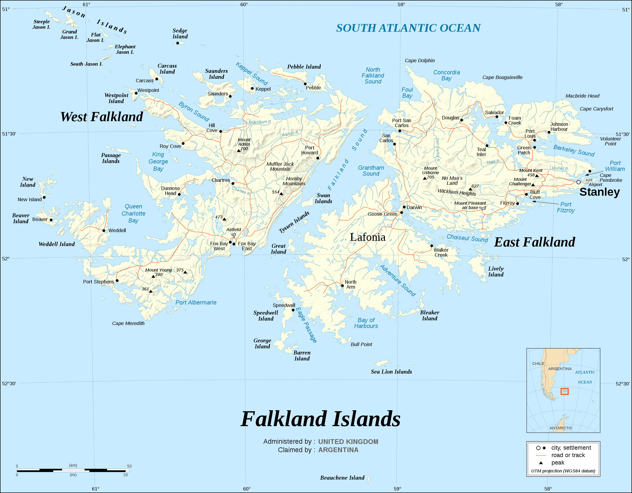
English: The Falkland Islands are an archipelago in the South Atlantic Ocean, located 300 miles off the coast of Argentina. They consist of two main islands, East Falkland and West Falkland, together with about 700 smaller islands. Stanley, on East Falkland, is the capital and largest city. The islands are a self-governing Overseas Territory of the United Kingdom.
Note : The shaded relief is a raster image embedded in the SVG file. Français : Carte en anglais des Îles Malouines. Les Malouines forment un archipel dans l'Océan Atlantique Sud à 480 km des côtes argentines. Il est composé de deux îles principales, East Falkland et West Falkland, et de 700 autres îles et îlots. Stanley, sur East Falkland, est la capitale et la plus grande agglomération de l'archipel. Les Malouines sont un territoire autonome du Royaume-Uni.
UTM projection ; WGS84 datum ; shaded relief (composite image of N-W, W and N lightning positions) ; |
||
| Dato | |||
| Kilde |
Own work, same map as Image:Falkland_Islands_topographic_map-en.svg but without topographic and bathymetric information ;
|
||
| Forfatter | Eric Gaba (Sting - fr:Sting) | ||
| Tilladelse (Genbrug af denne fil) |
|
||
| Andre versioner |
[]
|


.svg)


.svg)


|
SVG-filen indeholder indlejret tekst som let kan oversættes til dit sprog ved hjælp af [toolforge:svgtranslate/File:Falkland_Islands_map_shaded_relief-en.svglink dette automatiske værktøj]. Lær mere her. |
Licensering
[redigér]

|
Tilladelse er givet til at kopiere, distribuere og/eller ændre dette dokument under betingelserne i GNU Free Documentation License', Version 1.2 eller enhver senere version udgivet af Free Software Foundation; uden et invariant afsnit, ingen forsidetekster, og ingen bagsidetekst. En kopi af licensen er inkluderet i afsnittet GNU Free Documentation License. |
- Du må frit:
- at dele – at kopiere, distribuere og overføre værket
- at remixe – at tilpasse værket
- Under følgende vilkår:
- kreditering – Du skal give passende kreditering, angive et link til licensen, og oplyse om der er foretaget ændringer. Du må gøre det på enhver fornuftig måde, men ikke på en måde der antyder at licensgiveren godkender dig eller din anvendelse.
- deling på samme vilkår – Hvis du bearbejder, ændrer eller bygger videre på dette værk, skal du distribuere dine bidrag under den samme eller en kompatibel licens som originalen.
Filhistorik
Klik på en dato/tid for at se filen som den så ud på det tidspunkt.
| Dato/tid | Miniaturebillede | Dimensioner | Bruger | Kommentar | |
|---|---|---|---|---|---|
| nuværende | 8. okt. 2011, 10:36 | | 2.550 × 1.990 (1,44 MB) | Nilfanion (diskussion | bidrag) | Reverted to version as of 15:00, 6 September 2008 - keep the raster info, it is value-added data |
| 8. okt. 2011, 08:35 |  | 2.550 × 1.990 (728 KB) | Cwbm (commons) (diskussion | bidrag) | removed raster data, should not affect the image | |
| 6. sep. 2008, 15:00 |  | 2.550 × 1.990 (1,44 MB) | Sting (diskussion | bidrag) | New standard colors | |
| 16. nov. 2007, 20:09 |  | 2.550 × 1.990 (1,46 MB) | Sting (diskussion | bidrag) | {{Information |Description={{en|The '''Falkland Islands''' are an archipelago in the South Atlantic Ocean, located 300 miles off the coast of Argentina. They consist of two main islands, East Falkland and West Falkland, together with about 700 smaller |
Du kan ikke overskrive denne fil.
Filanvendelse
De følgende 27 sider bruger denne fil:
- Atlas of the Falkland Islands
- Falkland Islands
- User:Sting/Gallery: Regional maps
- File:Falkland Islands blank.svg
- File:Falkland Islands map shaded relief-en.svg
- File:Falkland Islands map shaded relief-fr.svg
- File:Falkland Islands topographic map-ca.svg
- File:Falkland Islands topographic map-da.svg
- File:Falkland Islands topographic map-de.svg
- File:Falkland Islands topographic map-en.svg
- File:Falkland Islands topographic map-en librsvg.png
- File:Falkland Islands topographic map-en rendersvg.png
- File:Falkland Islands topographic map-es.svg
- File:Falkland Islands topographic map-es (argentinian names places).svg
- File:Falkland Islands topographic map-fr.svg
- File:Falkland Islands topographic map-it.svg
- File:Falkland Islands topographic map-ka.svg
- File:Falkland Islands topographic map-mk.svg
- File:Falkland Islands topographic map-nb.svg
- File:Falkland Islands topographic map-nl.svg
- File:Falkland Islands topographic map-nn.svg
- File:Falkland Islands topographic map-pl.svg
- File:Falkland Islands topographic map-pt (argentinian names places).svg
- File:Falkland Islands topographic map-ru.svg
- File:Falkland Islands topographic map-sr.svg
- File:Falkland Islands topographic map-zh-hans.svg
- Template:Other versions/Falkland Islands topographic map
Global filanvendelse
Følgende andre wikier anvender denne fil:
- Anvendelser på azb.wikipedia.org
- Anvendelser på bn.wikipedia.org
- Anvendelser på en.wikipedia.org
- Anvendelser på pt.wikipedia.org
- Anvendelser på ru.wikipedia.org
- Anvendelser på to.wikipedia.org
- Anvendelser på uk.wikipedia.org