File:Fortifikationskarta över Masstricht - Skoklosters slott - 98000.tif
Jump to navigation
Jump to search

Size of this JPG preview of this TIF file: 704 × 600 pixels. Other resolutions: 282 × 240 pixels | 563 × 480 pixels | 901 × 768 pixels | 1,202 × 1,024 pixels | 2,403 × 2,048 pixels | 4,393 × 3,744 pixels.

Original file (4,393 × 3,744 pixels, file size: 47.07 MB, MIME type: image/tiff, 2 pages)
Captions
Captions
Add a one-line explanation of what this file represents
| Karta
( |
|||||||||||||||||||||||||||
|---|---|---|---|---|---|---|---|---|---|---|---|---|---|---|---|---|---|---|---|---|---|---|---|---|---|---|---|
| Photographer | |||||||||||||||||||||||||||
| Manufacturer | Albert de Herbort (ingenjör) | ||||||||||||||||||||||||||
| Title |
Karta |
||||||||||||||||||||||||||
| Original caption |
Note: For documentary purposes the original description has been retained. Factual corrections and alternative descriptions are encouraged separately from the original description. Fortifikationskarta över Masstricht.Nyckelord: Karta |
||||||||||||||||||||||||||
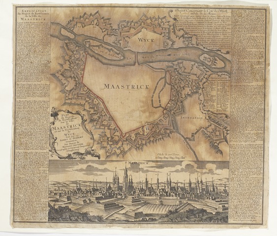
| Description |
Svenska: Koppartryck samt hankolorerad på papper. Vänster sida ”Explication du Projekt de Fortification de la Ville de Maastrick” forts. h. sida. I kartusch t.v. mitt på ” Plan du Project de Fortification Sur la Ville de Maastrick et sur la Fortification de Wyck. Fait par Albert de Herbort Ingenieur. Aux depens de Mathien Seutter. Geographe et Graveur Imperial d Augsbourg”. Upptill t.h. ”Project Concernant 6 cote de Wijch andela de la Meuse”. Nedtill pespektivåtergivning av Maastricht. |
||||||||||||||||||||||||||
| Date | from 1700 until 1756 | ||||||||||||||||||||||||||
| Dimensions | height: 510 mm (20.07 in); width: 585 mm (23.03 in) | ||||||||||||||||||||||||||
| Collection |
|
||||||||||||||||||||||||||
| Accession number | |||||||||||||||||||||||||||
| Source | LSH 98000 (sm_dig10617) | ||||||||||||||||||||||||||
| Permission (Reusing this file) |
|
||||||||||||||||||||||||||
| Other versions |
|
||||||||||||||||||||||||||
| Error reporting | You can help by reporting errors and typos at Commons:LSH/Error reports. If the error was added by a Wikimedian and is not present on the museum's website, you can fix this page directly, without notifying. |
||||||||||||||||||||||||||


File history
Click on a date/time to view the file as it appeared at that time.
| Date/Time | Thumbnail | Dimensions | User | Comment | |
|---|---|---|---|---|---|
| current | 00:05, 21 November 2014 |  | 4,393 × 3,744, 2 pages (47.07 MB) | LSHuploadBot (talk | contribs) | {{LSH artwork |artist= |manufacturer= Albert de Herbort (ingenjör) |title= {{Title|Karta}} |description= {{sv|1=Koppartryck samt hankolorerad på papper.<br/>Vänster sida ”Explication du Projekt de Fortification de la Ville de Maastrick” forts.... |
You cannot overwrite this file.
File usage on Commons
The following 2 pages use this file: