File:Frankish Empire 481 to 814-en.svg
Naviqasiyaya keç
Axtarışa keç

Bu SVG-faylın PNG formatındakı bu görünüşünün ölçüsü: 792 × 600 piksel. Digər ölçülər: 317 × 240 piksel | 634 × 480 piksel | 1.014 × 768 piksel | 1.280 × 969 piksel | 2.560 × 1.939 piksel | 1.591 × 1.205 piksel.
Faylın orijinalı (SVG faylı, nominal olaraq 1.591 × 1.205 piksel, faylın ölçüsü: 834 KB)
Captions
Captions
Add a one-line explanation of what this file represents
Xülasə[redaktə]
| İzah |
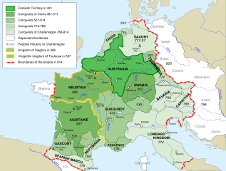
[] Afrikaans: Die veranderende strekking van die Frankiese Ryk van 481 tot 814. Alemannisch: S Frankeriich vo 481 bis 814. Bahasa Indonesia: Peta kebangkitan Kekaisaran Franka, dari tahun 481 hingga 814. Català: Mapa de l'expansió de l'Imperi Franc, de 481 a 814. Deutsch: Karte der Ausdehnung des Fränkischen Reichs 481 bis 814. English: Map of the rise of Frankish Empire, from 481 to 814. Español: Mapa de la expansión del Imperio Franco, entre 481 y 814. Euskara: Frankoen Inperioaren hedapenaren mapa, 481-814 urteen bitartean. Français : Carte de l'expansion de l'empire Franc, entre 481 et 814. Italiano: Carta dell'espansione dell'impero dei Franchi tra il 481 e il 814. Magyar: Frank Birodalom 481-814 Nederlands: Kaart van de opkomst van het Frankische Rijk, van 481 tot 814. Polski: Mapa rozwoju Imperium Franków w latach 481-814 Português: Mapa da expansão do Império Franco, entre 481 e 814. Română: Harta ascensiunii Imperiului franc, 481-814. Svenska: Karantanien i det frankiska riket (år 788 - 843). Ελληνικά: Η Φραγκική Αυτοκρατορία 481-814 Македонски: Карта на подемот на Франкското царство, од 481 до 814 г. Русский: Карта расширения империи франков, между 481 и 814. Українська: Карта розширення імперії Франків в період 481-814 рр. 日本語: カロリング朝の版図。 中文: 墨洛温王朝到加洛林王朝(481—814)的法兰克王国。 العربية : إمبراطوريَّة الفرنجة ما بين عاميّ 481 و814م |
| Tarix | |
| Mənbə |
Own work using:
|
| Müəllif | Sémhur |
| Digər versiyalar |
Derivative works of this file: Frankish Empire 481 to 814-sr.svg
[]
|
| Camera location | | View this and other nearby images on: OpenStreetMap |
|---|

|
This SVG file contains embedded text that can be translated into your language, using any capable SVG editor, text editor or the SVG Translate tool. For more information see: About translating SVG files. |
This W3C-unspecified vector image was created with Inkscape .
Lisenziya[redaktə]
I, the copyright holder of this work, hereby publish it under the following licenses:
| Copyleft: This work of art is free; you can redistribute it and/or modify it according to terms of the Free Art License. You will find a specimen of this license on the Copyleft Attitude site as well as on other sites. |
This file is licensed under the Creative Commons Attribution-Share Alike 3.0 Unported, 2.5 Generic, 2.0 Generic and 1.0 Generic license.
- Azadsınız:
- paylaşmaq – əsəri köçürmək, paylamaq və ötürmək üçün
- remiks etmək – əsəri adaptasiya etmək
- Aşağıdakı şərtlərə riayət etməklə:
- istinad – Müvafiq kredit verməlisiniz, lisenziyaya bir keçid verməlisiniz və dəyişikliklərin olub olmadığını bildirməlisiniz. Bunu hər hansı bir ağlabatan şəkildə edə bilərsiniz, ancaq lisenziyalaşdırıcının sizi və ya istifadənizi təsdiqləməsini təklif edən bir şəkildə deyil.
- bənzər paylaşma – Əsəri remix edirsinizsə, dəyişdirirsinizsə və ya üzərində iş aparırsınızsa, öz töhfələrinizi orijinalda olduğu kimi eyni və ya uyğun lisenziya altında yayımlamalısınız.
İstədiyiniz lisenziyanı seçə bilərsiniz.
Faylın tarixçəsi
Faylın əvvəlki versiyasını görmək üçün gün/tarix bölməsindəki tarixlərə klikləyin.
| Tarix/Vaxt | Kiçik şəkil | Ölçülər | İstifadəçi | Şərh | |
|---|---|---|---|---|---|
| indiki | 18:10, 5 sentyabr 2012 | | 1.591 × 1.205 (834 KB) | Hel-hama (müzakirə | töhfələr) | minor corrections |
| 17:35, 5 sentyabr 2012 |  | 1.591 × 1.205 (844 KB) | Hel-hama (müzakirə | töhfələr) | second attempt to upload file | |
| 19:34, 2 sentyabr 2012 |  | 1.735 × 1.227 (331 KB) | Hel-hama (müzakirə | töhfələr) | Reverted to version as of 05:50, 7 May 2012 | |
| 19:30, 2 sentyabr 2012 |  | 1.796 × 1.796 (973 KB) | Hel-hama (müzakirə | töhfələr) | General improvements to map to make it more easy to read. | |
| 05:50, 7 may 2012 |  | 1.735 × 1.227 (331 KB) | Oosh (müzakirə | töhfələr) | Fixed discrepancy between colours used in 481 Territory and Legend. Increased the blue channel in 714-768 Conquests for better contrast against 481-511 conquests. -~~~~ | |
| 14:41, 15 oktyabr 2007 |  | 1.735 × 1.227 (331 KB) | Sémhur (müzakirə | töhfələr) | {{Information |Description=Map of the rise of Frankish Empire, from 481 to 814. |Source=Own work, from Image:Frankish empire.jpg. |Date=2007-10-15 |Author= Sémhur ·<font size="4" color="forestgreen">[[:fr:Special:Emailuser/Sémhur| |
Siz bu faylı yenidən yükləyə bilməzsiniz.
Fayl keçidləri
Aşağıdakı 37 səhifə bu faylı istifadə edir:
- Atlas of Germany
- Atlas of Slovenia
- Atlas of Switzerland
- Atlas of the Frankish Empire
- Wikimedia Conference Japan 2009/Commons写真展
- User:Miya/Introduction
- User:Sémhur/Profile
- Commons:Bu proje sayfasının diğer dil sürümleri
- Commons:Conhece os nossos ilustradores
- Commons:Conoce a nuestros ilustradores
- Commons:Descobreix els nostres il.lustradors
- Commons:Descobrètz nòstres illustrators
- Commons:Découvrez nos illustrateurs
- Commons:Meet our illustrators
- Commons:Meet our illustrators/People
- Commons:Poznaj naszych grafików
- Commons:Scopri i nostri illustratori
- Commons:Scummigghia ê nostri llustratura
- Commons:Unsere Illustratoren stellen sich vor
- Commons:Unseri Illustratore stelle sich vor
- Commons:Upoznajte naše ilustratore
- Commons:Çizerlerimizle tanışın
- Commons:Запознајте ги нашите илустратори
- Commons:Знайомтесь з нашими ілюстраторами
- Commons:Знакомьтесь с нашими иллюстраторами
- Commons:قابل رسامينا
- Commons:私達のイラストレータをご紹介します
- Commons:结识我们的插图师
- Commons:우리들의 삽화가를 만나보세요
- File:Frankish Empire 481 to 814-ar.png
- File:Frankish Empire 481 to 814-ar.svg
- File:Frankish Empire 481 to 814-ca.svg
- File:Frankish Empire 481 to 814-el.png
- File:Frankish Empire 481 to 814-eu.svg
- File:Frankish Empire 481 to 814-mk.svg
- File:Frankish Empire 481 to 814-sr.svg
- File:Frankish empire.jpg
Faylın qlobal istifadəsi
Bu fayl aşağıdakı vikilərdə istifadə olunur:
- ar.wikipedia.org layihəsində istifadəsi
- av.wikipedia.org layihəsində istifadəsi
- azb.wikipedia.org layihəsində istifadəsi
- az.wikipedia.org layihəsində istifadəsi
- bh.wikipedia.org layihəsində istifadəsi
- bn.wikipedia.org layihəsində istifadəsi
- bs.wikipedia.org layihəsində istifadəsi
- ceb.wikipedia.org layihəsində istifadəsi
- cs.wikipedia.org layihəsində istifadəsi
- da.wikipedia.org layihəsində istifadəsi
- en.wikipedia.org layihəsində istifadəsi
- Charlemagne
- Europe
- 774
- 481
- History of Burgundy
- History of the European Union
- Carolingian Empire
- Austrasia
- Carantania
- Carolingian dynasty
- List of Frankish kings
- Frankish language
- Charles the Younger
- Portal:European Union
- Kingdom of Soissons
- Benveniste
- Saxon Wars
- History of Western civilization
- List of revolutions and rebellions
- Duchy of Franconia
- User talk:Trasamundo
- Frisian–Frankish wars
- Wikipedia:WikiProject Maps/Conventions/Historical maps
- Duchy of Thuringia
- Succession to the French throne
- User:Kazkaskazkasako/Books/History
- History of Metz
Bu faylın qlobal istifadəsinə baxın.