File:French Algeria evolution 1830-1962 map-fr.svg
Pāriet uz navigāciju
Pāriet uz meklēšanu

Size of this PNG preview of this SVG file: 604 × 600 pikseļi. Citi izmēri: 242 × 240 pikseļi | 483 × 480 pikseļi | 773 × 768 pikseļi | 1 031 × 1 024 pikseļi | 2 062 × 2 048 pikseļi | 1 287 × 1 278 pikseļi.
Sākotnējais fails (SVG fails, definētais izmērs 1 287 × 1 278 pikseļi, faila izmērs: 1,86 MB)
Captions
Captions
Pievieno vienas rindiņas aprakstu, ko šis fails attēlo
Kopsavilkums[labot šo sadaļu]
| Apraksts |
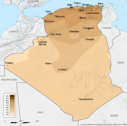
English: French Algeria evolution map, from 1830 to 1962.
Français : Carte montrant l'évolution territoriale de l'Algérie française, de 1830 à 1962.
|
| Datums | (UTC) |
| Avots |
English:
Français :
|
| Autors | Sémhur |
| Citas versijas |
Derivative works of this file: French Algeria evolution 1830-1962 map-es.svg |
| Atsauce (required by the license) | © Sémhur / Wikimedia Commons / |
| SVG veidošana |
| Camera location | | View this and other nearby images on: OpenStreetMap |
|---|
Licence[labot šo sadaļu]
Es, šī darba autortiesību īpašnieks, publicēju to saskaņā ar šīm licencēm:
| Copyleft: This work of art is free; you can redistribute it and/or modify it according to terms of the Free Art License. You will find a specimen of this license on the Copyleft Attitude site as well as on other sites. |
This file is licensed under the Creative Commons Attribution-Share Alike 4.0 International, 3.0 Unported, 2.5 Generic, 2.0 Generic and 1.0 Generic license.
- Jūs varat brīvi:
- koplietot – kopēt, izplatīt un pārraidīt darbu
- remiksēt – pielāgot darbu
- Saskaņā ar šādiem nosacījumiem:
- atsaucoties – Tev ir jānorāda autors, saite uz licenci un to, vai veiktas kādas izmaiņas. To var darīt jebkādā saprātīgā veidā, bet ne tādā, kas norādītu, ka licencētājs atbalsta tevi vai veidu, kā tu izmanto šo darbu.
- nemainot licenci – Ja tu miksē, pārveido vai izmanto materiālu, tev savs devums jāpublicē ar to pašu vai saderīgu licenci kā oriģināls.
Jūs varat izvēlēties licenci pēc jūsu vēlmes.
Original upload log[labot šo sadaļu]
This image is a derivative work of the following images:
- File:Algeria_location_map.svg licensed with Cc-by-sa-3.0, GFDL
- 2009-11-17T12:51:26Z Sting 1287x1278 (372657 Bytes) == {{int:filedesc}} == {{Location|28|19|00|N|1|39|00|E|scale:8000000}} {{Information |Description={{en|Blank administrative map of [[:en:Algeria|Algeria]], for geo-location purposes.}} {{fr|Carte administrative vierge de l'[
Uploaded with derivativeFX
Faila hronoloģija
Uzklikšķini uz datums/laiks kolonnā esošās saites, lai apskatītos, kā šis fails izskatījās tad.
| Datums/Laiks | Attēls | Izmēri | Dalībnieks | Komentārs | |
|---|---|---|---|---|---|
| tagadējais | 2014. gada 22. maijs, plkst. 19.34 | | 1 287 × 1 278 (1,86 MB) | Sémhur (diskusija | devums) | Valid SVG |
| 2012. gada 29. septembris, plkst. 18.57 |  | 1 287 × 1 278 (1,86 MB) | Sémhur (diskusija | devums) | == {{int:filedesc}} == {{Information |Description={{Multilingual description |en= en:French Algeria evolution map, from 1830 to 1962. |fr= Carte de l'fr:Algérie française, de 1830 à 1962. }} <br/> Scale: 1:6,800,000 (precision: 1,700 m)... |
Šo failu nevar pārrakstīt.
Faila lietojums
Šo failu izmanto šajās 3 lapās:
Globālais faila lietojums
Šīs Vikipēdijas izmanto šo failu:
- Izmantojums ast.wikipedia.org
- Izmantojums bg.wikipedia.org
- Izmantojums ca.wikipedia.org
- Izmantojums da.wikipedia.org
- Izmantojums de.wikipedia.org
- Izmantojums en.wikipedia.org
- Izmantojums eu.wikipedia.org
- Izmantojums fa.wikipedia.org
- Izmantojums fi.wikipedia.org
- Izmantojums fr.wikipedia.org
- Izmantojums ga.wikipedia.org
- Izmantojums hy.wikipedia.org
- Izmantojums id.wikipedia.org
- Izmantojums it.wikipedia.org
- Izmantojums ja.wikipedia.org
- Izmantojums ka.wikipedia.org
- Izmantojums ko.wikipedia.org
- Izmantojums lt.wikipedia.org
- Izmantojums lv.wikipedia.org
- Izmantojums mk.wikipedia.org
- Izmantojums ms.wikipedia.org
- Izmantojums mt.wikipedia.org
- Izmantojums nl.wikipedia.org
- Izmantojums pl.wikipedia.org
- Izmantojums pnb.wikipedia.org
- Izmantojums pt.wikipedia.org
- Izmantojums ro.wikipedia.org
- Izmantojums ru.wikipedia.org
Skatīt šī faila pilno globālo izmantojumu.