File:French Algeria evolution 1830-1962 map-fr.svg
跳至導覽
跳至搜尋

此 SVG 檔案的 PNG 預覽的大小:604 × 600 像素。 其他解析度:242 × 240 像素 | 483 × 480 像素 | 773 × 768 像素 | 1,031 × 1,024 像素 | 2,062 × 2,048 像素 | 1,287 × 1,278 像素。
原始檔案 (SVG 檔案,表面大小:1,287 × 1,278 像素,檔案大小:1.86 MB)
說明
說明
添加單行說明來描述出檔案所代表的內容
摘要[編輯]
| 描述 |
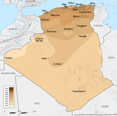
English: French Algeria evolution map, from 1830 to 1962.
Français : Carte montrant l'évolution territoriale de l'Algérie française, de 1830 à 1962.
|
| 日期 | (UTC) |
| 來源 |
English:
Français :
|
| 作者 | Sémhur |
| 其他版本 | |
| 姓名標示 (由许可协议要求) | © Sémhur / Wikimedia Commons / |
| SVG開發 | 這個SVG 檔案使用了內置文字,可以使用任何文字編輯器輕鬆翻譯。 |
| 拍攝地點 | | 位於此地的本圖片與其他圖片: OpenStreetMap |
|---|
授權條款[編輯]
我,本作品的著作權持有者,決定用以下授權條款發佈本作品:
| 公共版權:本藝術作品是自由的,您可以依據自由藝術作品許可協議的條款傳播和/或修改本藝術作品。您可以在Copyleft Attitude網站或其他網站找到該許可協議的樣本。 |
This file is licensed under the Creative Commons Attribution-Share Alike Attribution-Share Alike 4.0 International, 3.0 Unported, 2.5 Generic, 2.0 Generic and 1.0 Generic license.
- 您可以自由:
- 分享 – 複製、發佈和傳播本作品
- 重新修改 – 創作演繹作品
- 惟需遵照下列條件:
- 姓名標示 – 您必須指名出正確的製作者,和提供授權條款的連結,以及表示是否有對內容上做出變更。您可以用任何合理的方式來行動,但不得以任何方式表明授權條款是對您許可或是由您所使用。
- 相同方式分享 – 如果您利用本素材進行再混合、轉換或創作,您必須基於如同原先的相同或兼容的條款,來分布您的貢獻成品。
您可以選擇您需要的授權條款。
原始上傳日誌[編輯]
This image is a derivative work of the following images:
- File:Algeria_location_map.svg licensed with Cc-by-sa-3.0, GFDL
- 2009-11-17T12:51:26Z Sting 1287x1278 (372657 Bytes) == {{int:filedesc}} == {{Location|28|19|00|N|1|39|00|E|scale:8000000}} {{Information |Description={{en|Blank administrative map of [[:en:Algeria|Algeria]], for geo-location purposes.}} {{fr|Carte administrative vierge de l'[
Uploaded with derivativeFX
檔案歷史
點選日期/時間以檢視該時間的檔案版本。
| 日期/時間 | 縮圖 | 尺寸 | 使用者 | 備註 | |
|---|---|---|---|---|---|
| 目前 | 2014年5月22日 (四) 19:34 | | 1,287 × 1,278(1.86 MB) | Sémhur(留言 | 貢獻) | Valid SVG |
| 2012年9月29日 (六) 18:57 |  | 1,287 × 1,278(1.86 MB) | Sémhur(留言 | 貢獻) | == {{int:filedesc}} == {{Information |Description={{Multilingual description |en= en:French Algeria evolution map, from 1830 to 1962. |fr= Carte de l'fr:Algérie française, de 1830 à 1962. }} <br/> Scale: 1:6,800,000 (precision: 1,700 m)... |
無法覆蓋此檔案。
檔案用途
下列3個頁面有用到此檔案:
全域檔案使用狀況
以下其他 wiki 使用了這個檔案:
- ast.wikipedia.org 的使用狀況
- bg.wikipedia.org 的使用狀況
- ca.wikipedia.org 的使用狀況
- da.wikipedia.org 的使用狀況
- de.wikipedia.org 的使用狀況
- en.wikipedia.org 的使用狀況
- eu.wikipedia.org 的使用狀況
- fa.wikipedia.org 的使用狀況
- fi.wikipedia.org 的使用狀況
- fr.wikipedia.org 的使用狀況
- ga.wikipedia.org 的使用狀況
- hy.wikipedia.org 的使用狀況
- id.wikipedia.org 的使用狀況
- it.wikipedia.org 的使用狀況
- ja.wikipedia.org 的使用狀況
- ka.wikipedia.org 的使用狀況
- ko.wikipedia.org 的使用狀況
- lt.wikipedia.org 的使用狀況
- lv.wikipedia.org 的使用狀況
- mk.wikipedia.org 的使用狀況
- ms.wikipedia.org 的使用狀況
- mt.wikipedia.org 的使用狀況
- nl.wikipedia.org 的使用狀況
- pl.wikipedia.org 的使用狀況
- pnb.wikipedia.org 的使用狀況
- pt.wikipedia.org 的使用狀況
檢視此檔案的更多全域使用狀況。