File:Gedenkstein Stahnsdorfer Damm (Wann) Gustav Ludwig Otto Eduard Graf von Waldersee.jpg
Jump to navigation
Jump to search
Size of this preview: 800 × 310 pixels. Other resolutions: 320 × 124 pixels | 640 × 248 pixels | 1,024 × 397 pixels | 1,280 × 496 pixels | 2,560 × 992 pixels | 7,467 × 2,894 pixels.
Original file (7,467 × 2,894 pixels, file size: 35.18 MB, MIME type: image/jpeg)
Captions
Captions
Add a one-line explanation of what this file represents
Summary
[edit]_Gustav_Ludwig_Otto_Eduard_Graf_von_Waldersee.jpg&action=edit§ion=1)
| Camera location | | View this and other nearby images on: OpenStreetMap |
|---|
_Gustav_Ludwig_Otto_Eduard_Graf_von_Waldersee.jpg¶ms=052.413056_N_0013.181667_E_globe:Earth_type:camera_alt:57_source:exif_&language=en)
| Description | |
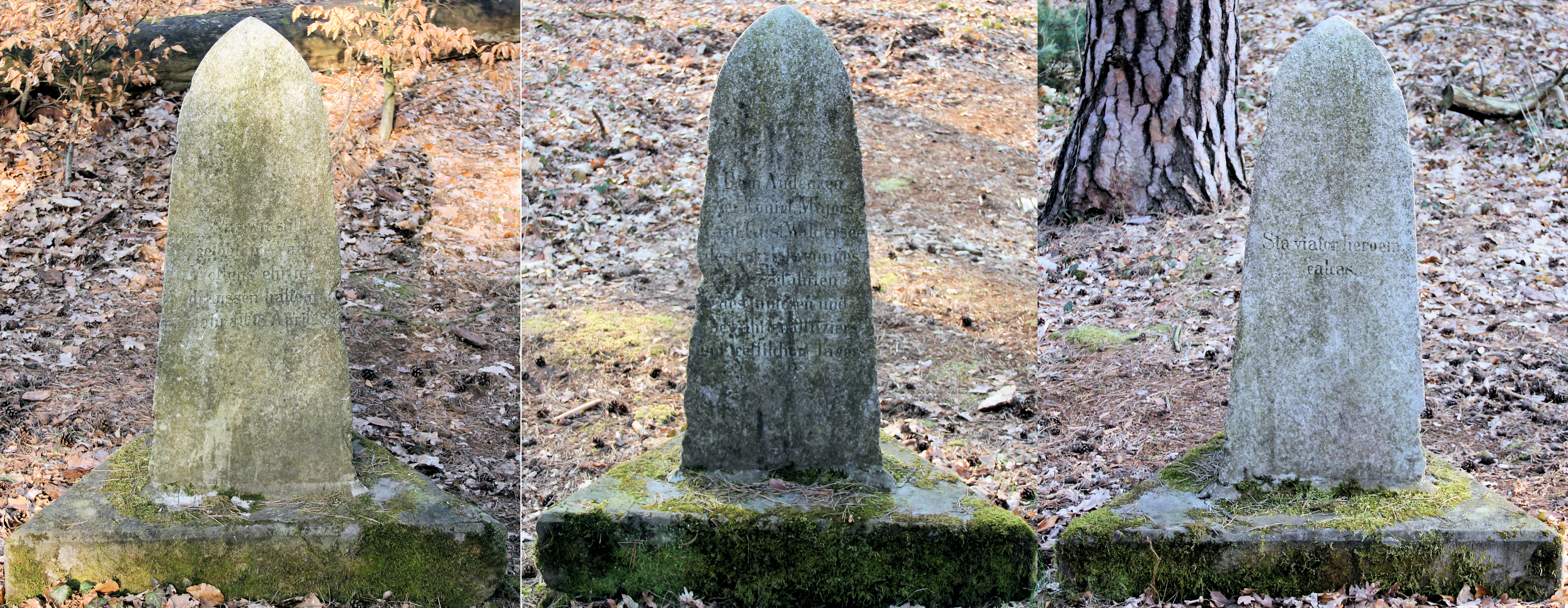
| Inscription | 1. Inschrift: Was wir still gelobt im Wald, wollten es ehrlich draußen halten. 35 Jahre alt 18. April 1861 2. Inschrift:Dem Andenken des kgl. Majors Graf Gust. Waldersee, des lieben Freundes und Gefährten des tapferen und bewährten Offiziers und trefflichen Jägers. 3. Inschrift: Sta viator heroem calcas |
| OpenStreetMap | Node 8261588229 |
| Date | |
| Source | Self-photographed |
| Author | OTFW, Berlin |
| Object location | | View this and other nearby images on: OpenStreetMap |
|---|
_Gustav_Ludwig_Otto_Eduard_Graf_von_Waldersee.jpg¶ms=052.414089_N_0013.180218_E_globe:Earth_class:object_type:object_source:OSM_&language=en)
Licensing
[edit]_Gustav_Ludwig_Otto_Eduard_Graf_von_Waldersee.jpg&action=edit§ion=2)
I, the copyright holder of this work, hereby publish it under the following licenses:

|
Permission is granted to copy, distribute and/or modify this document under the terms of the GNU Free Documentation License, Version 1.2 or any later version published by the Free Software Foundation; with no Invariant Sections, no Front-Cover Texts, and no Back-Cover Texts. A copy of the license is included in the section entitled GNU Free Documentation License. |
This file is licensed under the Creative Commons Attribution-Share Alike 3.0 Unported, 2.5 Generic, 2.0 Generic and 1.0 Generic license.
- You are free:
- to share – to copy, distribute and transmit the work
- to remix – to adapt the work
- Under the following conditions:
- attribution – You must give appropriate credit, provide a link to the license, and indicate if changes were made. You may do so in any reasonable manner, but not in any way that suggests the licensor endorses you or your use.
- share alike – If you remix, transform, or build upon the material, you must distribute your contributions under the same or compatible license as the original.
You may select the license of your choice.
|
The photographical reproduction of this work is covered under the article § 59 of the German copyright law, which states that "It shall be permissible to reproduce, by painting, drawing, photography or cinematography, works which are permanently located on public ways, streets or places and to distribute and publicly communicate such copies. For works of architecture, this provision shall be applicable only to the external appearance."
As with all other “limits of copyright by legally permitted uses”, no changes to the actual work are permitted under § 62 of the German copyright law (UrhG). See Commons:Copyright rules by territory/Germany#Freedom of panorama for more information.
|
File history
Click on a date/time to view the file as it appeared at that time.
| Date/Time | Thumbnail | Dimensions | User | Comment | |
|---|---|---|---|---|---|
| current | 07:00, 31 March 2011 | 7,467 × 2,894 (35.18 MB) | OTFW (talk | contribs) | {{Location|52|24|47|N|13|10|54|E|alt:57_source:exif_heading:?}} {{Information |Description={{de|1=Gedenkstein, Gustav von Waldersee, Stahnsdorfer Damm, Berlin-Wannsee, Deutschland}} {{en|1=Memorial s |
You cannot overwrite this file.
File usage on Commons
The following 4 pages use this file:
File usage on other wikis
The following other wikis use this file:
- Usage on de.wikipedia.org
_Gustav_Ludwig_Otto_Eduard_Graf_von_Waldersee.jpg&oldid=905991847)