File:Gibraltar map-en-edit2.svg
跳至導覽
跳至搜尋

此 SVG 檔案的 PNG 預覽的大小:385 × 600 像素。 其他解析度:154 × 240 像素 | 308 × 480 像素 | 493 × 768 像素 | 657 × 1,024 像素 | 1,314 × 2,048 像素 | 1,000 × 1,558 像素。
原始檔案 (SVG 檔案,表面大小:1,000 × 1,558 像素,檔案大小:1.46 MB)
說明
說明
添加單行說明來描述出檔案所代表的內容
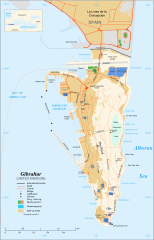
Map of Gibraltar
摘要
[編輯]
|
| 拍攝地點 | | 位於此地的本圖片與其他圖片: OpenStreetMap |
|---|
| 描述 |
English: Map in English of Gibraltar
Français : Carte en anglais de Gibraltar |
| 日期 | |
| 來源 |
English: adapted from: Image:Gibraltar map-en.svg
Français : Création personnelle ;
|
| 作者 | Original by Eric Gaba (Sting), label/legend edits by Jeff Dahl |
| 授權許可 (重用此檔案) |
Attribution and Share-Alike required |
| 其他版本 |
|


|
This SVG file contains embedded text that can be translated into your language, using any capable SVG editor, text editor or the SVG Translate tool. For more information see: About translating SVG files. |
授權條款
[編輯]
我,本作品的著作權持有者,決定用以下授權條款發佈本作品:

|
已授權您依據自由軟體基金會發行的無固定段落、封面文字和封底文字GNU自由文件授權條款1.2版或任意後續版本,對本檔進行複製、傳播和/或修改。該協議的副本列在GNU自由文件授權條款中。 |
This file is licensed under the Creative Commons Attribution-Share Alike Attribution-Share Alike 4.0 International, 3.0 Unported, 2.5 Generic, 2.0 Generic and 1.0 Generic license.
- 您可以自由:
- 分享 – 複製、發佈和傳播本作品
- 重新修改 – 創作演繹作品
- 惟需遵照下列條件:
- 姓名標示 – 您必須指名出正確的製作者,和提供授權條款的連結,以及表示是否有對內容上做出變更。您可以用任何合理的方式來行動,但不得以任何方式表明授權條款是對您許可或是由您所使用。
- 相同方式分享 – 如果您利用本素材進行再混合、轉換或創作,您必須基於如同原先的相同或兼容的條款,來分布您的貢獻成品。
您可以選擇您需要的授權條款。
檔案歷史
點選日期/時間以檢視該時間的檔案版本。
| 日期/時間 | 縮圖 | 尺寸 | 用戶 | 備註 | |
|---|---|---|---|---|---|
| 目前 | 2017年4月5日 (三) 16:36 | | 1,000 × 1,558(1.46 MB) | RaviC(對話 | 貢獻) | + University, Ferry terminal (& Route), Cathedral |
| 2007年12月11日 (二) 18:52 |  | 1,000 × 1,558(1.79 MB) | Jeff Dahl(對話 | 貢獻) | resized 1200 down to 1000px wide, minor label fixes | |
| 2007年12月10日 (一) 17:08 |  | 1,200 × 1,870(1.78 MB) | Jeff Dahl(對話 | 貢獻) | {{inkscape}} {{Location|36|08|00|N|5|21|00|W|type:city_scale:50000}} {{Information |Description=Map in English of Gibraltar |Source=adapted from: Image:Gibraltar map-en.svg <br/>Map created using screenshots of [[:en:Google Ea |
無法覆蓋此檔案。
檔案用途
下列37個頁面有用到此檔案:
- User:Hide on Rosé/Commons:Translation possible/Tìm hiểu thêm
- Commons:Translation possible/Ajuda
- Commons:Translation possible/Aprenda mais
- Commons:Translation possible/Aprende más
- Commons:Translation possible/Dowiedz się więcej
- Commons:Translation possible/Learn more
- Commons:Translation possible/Learn more/tr
- Commons:Translation possible/Mehr erfahren
- Commons:Translation possible/Para saber máis
- Commons:Translation possible/Per saperne di più
- Commons:Translation possible/Saznajte više
- Commons:Translation possible/Дознајте повеќе
- Commons:Translation possible/اطلاعات بیشتر
- Commons:Translation possible/了解更多
- Commons:Translation possible/詳情
- Commons:Translation possible/詳細
- Commons:Translation possible/더 보기
- File:Gibraltar map-HE.svg
- File:Gibraltar map-de.svg
- File:Gibraltar map-en.svg
- File:Gibraltar map-es.svg
- File:Gibraltar map-fr.svg
- File:Gibraltar map-hu.svg
- File:Gibraltar map-it.svg
- File:Gibraltar map-mk.svg
- File:Gibraltar map-ms.svg
- File:Gibraltar map-pl.svg
- File:Gibraltar map-uk.svg
- File:Gibraltar map-ur.svg
- File:Gibraltar map (claimed isthmus)-es.svg
- File:Gibraltar map (non Utrech territories)-es.svg
- File:Gibraltar map (reclaimed land)-es.svg
- File:Xibraltarplano-en.jpg
- File:Xibraltarplano-es.jpg
- File:Xibraltarplano-es cut.jpg
- File:Xibraltarplano-gl.jpg
- Template:Other versions/Gibraltar map
-es.svg)
-es.svg)
-es.svg)
全域檔案使用狀況
以下其他 wiki 使用了這個檔案:
- af.wikipedia.org 的使用狀況
- ar.wikipedia.org 的使用狀況
- av.wikipedia.org 的使用狀況
- azb.wikipedia.org 的使用狀況
- bg.wikipedia.org 的使用狀況
- bn.wikipedia.org 的使用狀況
- bs.wikipedia.org 的使用狀況
- ceb.wikipedia.org 的使用狀況
- Plantilya:Location map Gibraltar
- Signal Hill
- White Rock
- Sandy Bay
- Roca Blanca
- Ailsa Craig
- Passage Point
- El Peñón
- The Rock
- Middle Hill
- Gibraltar (pagklaro)
- Rock of Gibraltar
- Deadmans Beach
- Eastern Beach
- Western Beach
- Punta Pasaje
- Punta Europa
- La Roca
- Governor’s Beach
- Camp Bay
- Europa Point
- Gibraltar Bay
- Cerro de Enmedio
- Blackstrap Bay
- Caledonian Canal
- Great Europa Point
- Gibilterra
- White Rock (bato sa Gyibraltar)
- Western Beach (lapyahan sa Gyibraltar)
- Signal Hill (bungtod sa Gyibraltar)
- Sandy Bay North
- Sandy Bay (luuk)
- Saint Michael's Cave
- Saint Abb's Head
- North Gorge
- Middle Hill (bungtod sa Gyibraltar)
- Mediterranean Steps
- Martin's Cave
- Europa Point (punta sa Gyibraltar)
- The Lido
- Levant Cave
- H.M.S. Rooke
檢視此檔案的更多全域使用狀況。