File:Giovanni Maria Tamburini, Le plan de la ville, cité, université fauxbourg de Paris, 1632-1641 - Paris Musées (with frame).jpg
Jump to navigation
Jump to search

Size of this preview: 775 × 599 pixels. Other resolutions: 310 × 240 pixels | 621 × 480 pixels | 993 × 768 pixels | 1,280 × 990 pixels | 2,560 × 1,980 pixels | 3,000 × 2,320 pixels.
Original file (3,000 × 2,320 pixels, file size: 1.32 MB, MIME type: image/jpeg)
Captions
Captions
Add a one-line explanation of what this file represents
Summary
[edit]| Title |
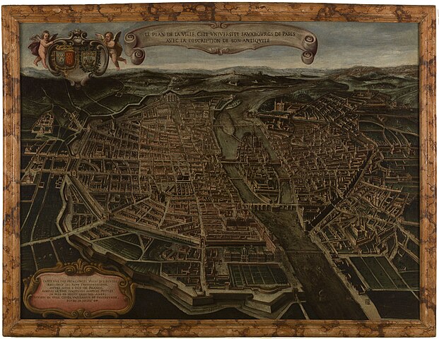
Français : Le plan de la ville, cité, université fauxbourg de Paris avec la description de son antiquité |
||||||||||||||||||||||||||
| Description |
English: An old map of Paris. |
||||||||||||||||||||||||||
| Date | between 1632 and 1641 | ||||||||||||||||||||||||||
| Source |
|
||||||||||||||||||||||||||
| Creator |
Giovanni Maria Tamburini |
||||||||||||||||||||||||||
| Geotemporal data | |||||||||||||||||||||||||||
| Map location | Paris | ||||||||||||||||||||||||||
| Georeferencing | If inappropriate please set warp_status = skip to hide. | ||||||||||||||||||||||||||
| Bibliographic data | |||||||||||||||||||||||||||
| Language | french | ||||||||||||||||||||||||||
| Place of publication | Paris | ||||||||||||||||||||||||||
| Archival data | |||||||||||||||||||||||||||
| Collection |
|
||||||||||||||||||||||||||
| Accession number |
P2860 |
||||||||||||||||||||||||||
| Dimensions | 152 x 203 cm | ||||||||||||||||||||||||||
| Medium | oil on canvas | ||||||||||||||||||||||||||

.jpg&action=edit§ion=1)
Licensing
[edit].jpg&action=edit§ion=2)
|
This work is in the public domain in its country of origin and other countries and areas where the copyright term is the author's life plus 100 years or fewer. | |
| This file has been identified as being free of known restrictions under copyright law, including all related and neighboring rights. | |
File history
Click on a date/time to view the file as it appeared at that time.
| Date/Time | Thumbnail | Dimensions | User | Comment | |
|---|---|---|---|---|---|
| current | 10:16, 14 September 2021 | | 3,000 × 2,320 (1.32 MB) | Paris 16 (talk | contribs) | Uploaded own work with UploadWizard |
You cannot overwrite this file.
File usage on Commons
The following 2 pages use this file:
.jpg&redirect=no)
.jpg&oldid=720673950)