File:Gokturkut.png
Naviqasiyaya keç
Axtarışa keç
Daha yüksək versiyası yoxdur.
Gokturkut.png (754 × 361 piksel, fayl həcmi: 558 KB, MIME növü: image/png)
Captions
Captions
Add a one-line explanation of what this file represents

|
This historical map image could be re-created using vector graphics as an SVG file. This has several advantages; see Commons:Media for cleanup for more information. If an SVG form of this image is available, please upload it and afterwards replace this template with
{{vector version available|new image name}}.
It is recommended to name the SVG file “Gokturkut.svg”—then the template Vector version available (or Vva) does not need the new image name parameter. |
Xülasə[redaktə]
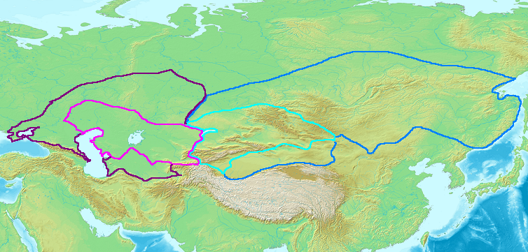
Gokturk khaganates at their height, c. 600 CE :
Western Gokturk: Lighter area is direct rule, darker areas show sphere of influence.
Eastern Gokturk: Lighter area is direct rule, darker areas show sphere of influence.
Made by User:Briangotts.
Lisenziya[redaktə]
I, the copyright holder of this work, hereby publish it under the following licenses:

|
Bu sənədi GNU Azad Sənədləşdirmə Lisenziyası, Versiya 1.2 və ya Azad Proqram Fondu tərəfindən nəşr olunan hər hansı sonrakı versiya şərtlərinə əsasən dəyişməz bölmələr, ön qapaq mətnləri və arxa qapaq mətnləri olmadan köçürmək, yayımlamaq və / və ya dəyişdirmək üçün icazə verilir; Lisenziyanın bir nüsxəsi GNU Azad Sənədləşdirmə Lisenziyası adlı hissəyə daxil edilmişdir. |
| Bu fayl Creative Commons Attribution-Share Alike 3.0 Unported lisenziyası altında yayımlanır. | ||
| ||
| This licensing tag was added to this file as part of the GFDL licensing update. |
İstədiyiniz lisenziyanı seçə bilərsiniz.
Faylın tarixçəsi
Faylın əvvəlki versiyasını görmək üçün gün/tarix bölməsindəki tarixlərə klikləyin.
| Tarix/Vaxt | Kiçik şəkil | Ölçülər | İstifadəçi | Şərh | |
|---|---|---|---|---|---|
| indiki | 17:11, 25 oktyabr 2006 | | 754 × 361 (558 KB) | Frode Inge Helland (müzakirə | töhfələr) | == Summary == Map of the Western (purple) and Eastern (blue) Gokturk khaganates at their height, c. 600 CE. Lighter areas show direct rule; darker areas show sphere of influence. == Licensing == {{GFDL-self}} [[Category:Historical maps by User:Br |
Siz bu faylı yenidən yükləyə bilməzsiniz.
Fayl keçidləri
Aşağıdakı 8 səhifə bu faylı istifadə edir:
Faylın qlobal istifadəsi
Bu fayl aşağıdakı vikilərdə istifadə olunur:
- ar.wikipedia.org layihəsində istifadəsi
- azb.wikipedia.org layihəsində istifadəsi
- az.wikipedia.org layihəsində istifadəsi
- ca.wikipedia.org layihəsində istifadəsi
- en.wikipedia.org layihəsində istifadəsi
- es.wikipedia.org layihəsində istifadəsi
- fa.wikipedia.org layihəsində istifadəsi
- fr.wikipedia.org layihəsində istifadəsi
- ja.wikipedia.org layihəsində istifadəsi
- kk.wikipedia.org layihəsində istifadəsi
- pl.wikipedia.org layihəsində istifadəsi
- pnb.wikipedia.org layihəsində istifadəsi
- ru.wikipedia.org layihəsində istifadəsi
- sah.wikipedia.org layihəsində istifadəsi
- sl.wikipedia.org layihəsində istifadəsi
- sv.wikipedia.org layihəsində istifadəsi
- tt.wikipedia.org layihəsində istifadəsi
- uk.wikipedia.org layihəsində istifadəsi
- zh.wikipedia.org layihəsində istifadəsi