File:Hannibal route of invasion-en.svg
Jump to navigation
Jump to search

Size of this PNG preview of this SVG file: 764 × 479 pixels. Other resolutions: 320 × 201 pixels | 640 × 401 pixels | 1,024 × 642 pixels | 1,280 × 803 pixels | 2,560 × 1,605 pixels.
Original file (SVG file, nominally 764 × 479 pixels, file size: 521 KB)
Captions
Captions
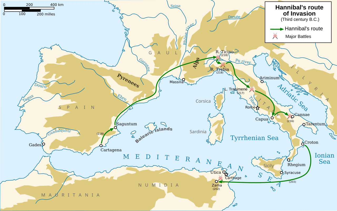
A map of the Mediterranean circa 218 BCE showing the route taken by Hannibal when invading Italy.
Summary[edit]
| Description |
English: Map in english of Hannibal's route of invasion
Français : Carte en anglais de la route empruntée par Hannibal durant son invasion |
| Date | |
| Source |
Own work based on: Europe topography map.png, Hannibal route of invasion.gif and Second Punic War full.svg
|
| Author | Abalg + traduction made by Pinpin |
| Other versions |
Derivative works of this file: Hannibal route of invasion-ar.png
[]
|


This W3C-unspecified vector image was created with Inkscape .

|
This SVG file contains embedded text that can be translated into your language, using any capable SVG editor, text editor or the SVG Translate tool. For more information see: About translating SVG files. |
Licensing[edit]
I, the copyright holder of this work, hereby publish it under the following licenses:

|
Permission is granted to copy, distribute and/or modify this document under the terms of the GNU Free Documentation License, Version 1.2 or any later version published by the Free Software Foundation; with no Invariant Sections, no Front-Cover Texts, and no Back-Cover Texts. A copy of the license is included in the section entitled GNU Free Documentation License. |
This file is licensed under the Creative Commons Attribution-Share Alike 3.0 Unported, 2.5 Generic, 2.0 Generic and 1.0 Generic license.
- You are free:
- to share – to copy, distribute and transmit the work
- to remix – to adapt the work
- Under the following conditions:
- attribution – You must give appropriate credit, provide a link to the license, and indicate if changes were made. You may do so in any reasonable manner, but not in any way that suggests the licensor endorses you or your use.
- share alike – If you remix, transform, or build upon the material, you must distribute your contributions under the same or compatible license as the original.
You may select the license of your choice.
File history
Click on a date/time to view the file as it appeared at that time.
| Date/Time | Thumbnail | Dimensions | User | Comment | |
|---|---|---|---|---|---|
| current | 12:21, 1 January 2014 | | 764 × 479 (521 KB) | Trlkly (talk | contribs) | Previous version accidentally had misalignment between landmasses and water on the edges of the image. |
| 12:01, 1 January 2014 |  | 764 × 479 (521 KB) | Trlkly (talk | contribs) | Redid the removal of the borders, this time via decreasing the viewport instead of stretching and thus creating inaccuracies. Still fully removed the black map border and gray water border. | |
| 08:23, 31 December 2013 |  | 766 × 482 (523 KB) | Trlkly (talk | contribs) | Removed both black and grey borders. Removed erroneous blue borders of landmasses at the edge of the map by stretching them outside the view area. Did not optimize, in order to preserve as much of the original information as possible. | |
| 18:51, 24 March 2008 |  | 770 × 486 (593 KB) | Pinpin (talk | contribs) | ||
| 18:48, 24 March 2008 |  | 770 × 486 (590 KB) | Pinpin (talk | contribs) | ||
| 18:38, 24 March 2008 |  | 770 × 486 (591 KB) | Pinpin (talk | contribs) | ||
| 09:16, 24 March 2008 |  | 770 × 486 (587 KB) | Pinpin (talk | contribs) | ||
| 20:13, 22 March 2008 |  | 770 × 486 (603 KB) | Pinpin (talk | contribs) | ||
| 20:12, 22 March 2008 |  | 770 × 486 (603 KB) | Pinpin (talk | contribs) | ||
| 20:07, 22 March 2008 |  | 770 × 486 (604 KB) | Pinpin (talk | contribs) |
You cannot overwrite this file.
File usage on Commons
The following 23 pages use this file:
- User talk:EraNavigator
- User talk:Pinpin
- File:Hannibal route of invasion-ar.gif
- File:Hannibal route of invasion-ar.png
- File:Hannibal route of invasion-en.svg
- File:Hannibal route of invasion-es.svg
- File:Hannibal route of invasion-fr.svg
- File:Hannibal route of invasion-gl.svg
- File:Hannibal route of invasion-hu.svg
- File:Hannibal route of invasion-it.svg
- File:Hannibal route of invasion-nl.png
- File:Hannibal route of invasion-nl.svg
- File:Hannibal route of invasion-pt.svg
- File:Hannibal route of invasion-zh-classical.png
- File:Hannibal route of invasion-zh.svg
- File:Hannibal route of invasion.gif
- File:Hannibal route of invasion - de.svg
- File:Hannibal route of invasion - en.svg
- File:Hannibal route of invasion - ka.svg
- File:Hannibal route of invasion - ru.svg
- File:Hannibal route of invasion de 2.svg
- File:Percorso di invasione di Annibale.png
- Template:Other versions/Hannibal route of invasion
File usage on other wikis
The following other wikis use this file:
- Usage on ar.wikipedia.org
- Usage on azb.wikipedia.org
- Usage on bg.wikipedia.org
- Usage on ca.wikipedia.org
- Usage on de.wikipedia.org
- Usage on en.wikipedia.org
- Usage on et.wikipedia.org
- Usage on he.wikipedia.org
- Usage on hr.wikipedia.org
- Usage on hy.wikipedia.org
- Usage on is.wikipedia.org
- Usage on ja.wikipedia.org
- Usage on ja.wikibooks.org
- Usage on lfn.wikipedia.org
- Usage on li.wikipedia.org
- Usage on lv.wikipedia.org
- Usage on ro.wikipedia.org
- Usage on si.wikipedia.org
- Usage on tr.wikipedia.org
- Usage on uk.wikipedia.org
- Usage on vi.wikipedia.org
- Usage on www.wikidata.org