File:Holy Roman Empire 1648.svg
Перейти к навигации
Перейти к поиску

Размер этого PNG-превью для исходного SVG-файла: 756 × 599 пкс. Другие разрешения: 303 × 240 пкс | 606 × 480 пкс | 969 × 768 пкс | 1280 × 1015 пкс | 2560 × 2030 пкс | 2283 × 1810 пкс.
Исходный файл (SVG-файл, номинально 2283 × 1810 пкс, размер файла: 3,07 МБ)
Краткие подписи
Краткие подписи
Добавьте однострочное описание того, что собой представляет этот файл
Краткое описание
[править]| Описание |
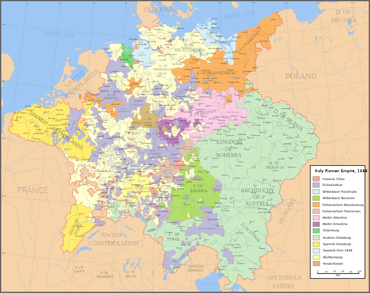
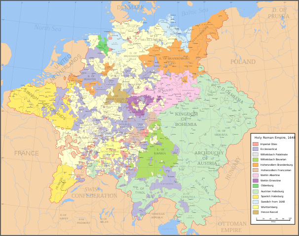
English: Map of the Holy Roman Empire in 1648, after the Peace of Westphalia which ended the Thirty Years' War. Deutsch: Karte des Heiligen Römischen Reiches 1648, nach dem Westfälischer Friede, der den Dreißigjähriger Krieg beendete. Français : Carte du Saint-Empire à 1648, après la paix de Westphalie qui mettent fin à la guerre de Trente Ans. Version française est disponible à File:Holy Roman Empire 1648 fr.svg. Српски / srpski: Мапа Светог римског царства у 1648, након Вестфалског мира којим је завршен Тридесетогодишњи рат.
|
English | Deutsch | Français | Српски |
||
|---|---|---|---|---|---|
| A | Archbishopric | Erzbistum | Archevêché | АДИЈ. | Архидијецеза |
| B | Bishopric | Bistum | Évêché | ДИЈ. | Дијецеза |
| C | County | Grafschaft | Comté | ОКР./ГРОФ. | Округ/грофовија |
| D | Duchy | Herzogtum | Duché | ВОЈВ. | Војводство |
| E | Electorate | Kurfürstentum | Électorat | ЕЛЕКТ. | Електорат |
| L | Landgraviate | Landgrafschaft | Landgraviat | ЛГРОФ. | Ландгрофовија |
| M | Margraviate | Markgrafschaft | Margraviat | МГРОФ. | Маркгрофовија |
| P | Principality | Fürstentum | Principauté | ГРОФ./ОКР. | Грофовија/округ |
Legend / Farblegende / Légende / Легенда
English | Deutsch | Français | Српски |
|
|---|---|---|---|---|
Palatinat des Wittelsbach |
||||
Wittelsbach Bavaria |
Wittelsbacher Bayern |
Bavière des Wittelsbach |
Вителсбах, баварски | |
Hohenzollern Franconia |
Hohenzollerner Franken |
Хоенцолерн, франконски | ||
Wettin Ernestine Saxony |
Wettiner Ernestiner Sachsen |
Saxe de la branche ernestine des Wettin |
Ветин, ернестински | |
Made from the public domain map "Central Europe about 1648" from the Historical Atlas by William R. Shepherd, at the Perry-Castañeda Library Map Collection at the University of Texas. Further information from Overy, Richard, 2006, The Times Complete history of the world Times Books ISBN 0007181299, and from this map
See also other maps at external links:
- Central Europe 1648
- Map on personal site, Europe in 1648
- Treaty of Westphalia
- 1648 map of Prussia
- Britannica, Spanish domains in 1648
Это векторное изображение было создано с помощью Inkscape .
(Повторное использование этого файла)

|
Разрешается копировать, распространять и/или изменять этот документ в соответствии с условиями GNU Free Documentation License версии 1.2 или более поздней, опубликованной Фондом свободного программного обеспечения, без неизменяемых разделов, без текстов, помещаемых на первой и последней обложке. Копия лицензии включена в раздел, озаглавленный GNU Free Documentation License. |
| Этот файл доступен по лицензии Creative Commons Attribution-Share Alike 3.0 Unported. | ||
| ||
| Этот признак лицензирования был добавлен к этому файлу как часть обновления лицензии GFDL. |
[]
-
 английский SVG
 -
 испанский SVG
 -
 французский SVG
 -
 грузинский SVG
 -
 сербский SVG
 -
 English: Blank PNG
 -
 английский PNG
 -
 испанский PNG
 -
 сербский PNG
 -
 русский PNG


|
Этот SVG-файл включает встроенный текст, который может быть переведён на ваш язык с помощью любого SVG-редактора, текстового редактора или Инструмента по переводу SVG-файлов. За подробной информацией обратитесь к статье О переводе SVG-файлов. |
История файла
Нажмите на дату/время, чтобы увидеть версию файла от того времени.
| Дата/время | Миниатюра | Размеры | Участник | Примечание | |
|---|---|---|---|---|---|
| текущий | 20:43, 24 июля 2022 | | 2283 × 1810 (3,07 МБ) | Maproom (обсуждение | вклад) | ZWEIBRCKEN -> ZWEIBRÜCKEN, Treves -> Trier, Liege -> Liège |
| 17:55, 18 мая 2022 |  | 2283 × 1810 (3,07 МБ) | Maproom (обсуждение | вклад) | Consistent, and German, spelling of "Mainz" | |
| 20:11, 25 мая 2021 |  | 2283 × 1810 (3,07 МБ) | ElCet (обсуждение | вклад) | added the biggest city of Upper Silesia back then | |
| 11:34, 23 марта 2018 |  | 2283 × 1810 (3,01 МБ) | Valentinian (обсуждение | вклад) | Cleanup some names including missing umlauts. Brunswick-Lüneburg -> Brunswick-Celle (see talk). Border north of Rendsburg seems slightly off to me and the situation in Holstein is rather simplified (jointly administered areas are missing). | |
| 19:09, 8 октября 2010 |  | 2283 × 1810 (3,01 МБ) | Joostik (обсуждение | вклад) | Ravenstein as part of Cleves | |
| 19:45, 9 августа 2009 |  | 2283 × 1810 (3,01 МБ) | Ysangkok (обсуждение | вклад) | simplify code (save as plain svg) | |
| 09:24, 14 июля 2009 |  | 2283 × 1810 (4,17 МБ) | Roke~commonswiki (обсуждение | вклад) | Zusmarshausen | |
| 15:16, 20 апреля 2007 |  | 2283 × 1810 (4,12 МБ) | Roke~commonswiki (обсуждение | вклад) | ||
| 02:04, 20 апреля 2007 |  | 2283 × 1810 (4,11 МБ) | Roke~commonswiki (обсуждение | вклад) | rm HRE text, darken labels | |
| 03:04, 18 апреля 2007 |  | 2283 × 1810 (4,11 МБ) | Roke~commonswiki (обсуждение | вклад) |
Вы не можете перезаписать этот файл.
Использование файла
Следующие 14 страниц используют этот файл:
- Atlas of Germany
- User:JMvanDijk
- User:Magog the Ogre/Maps of conflicts/2022 July
- User:Magog the Ogre/Maps of conflicts/2022 May
- User:Zinneke/Nei Biller iwwer Lëtzebuerg/2021 May 21-31
- User:Zinneke/Nei Biller iwwer Lëtzebuerg/2022 July 21-31
- User:Zinneke/Nei Biller iwwer Lëtzebuerg/2022 May 11-20
- File:Electorate of Saxony within the Holy Roman Empire 1648.svg
- File:Holy Roman Empire 1648-es.png
- File:Holy Roman Empire 1648-es.svg
- File:Holy Roman Empire 1648-sr.svg
- File:Holy Roman Empire 1648.svg
- File:Holy Roman Empire 1648 ka.svg
- Template:Other versions/Holy Roman Empire 1648
Глобальное использование файла
Данный файл используется в следующих вики:
- Использование в af.wikipedia.org
- Использование в azb.wikipedia.org
- Использование в az.wikipedia.org
- Использование в br.wikipedia.org
- Использование в ca.wikipedia.org
- Использование в ckb.wikipedia.org
- Использование в cs.wikipedia.org
- Использование в el.wikipedia.org
- Использование в en.wikipedia.org
- Peace of Westphalia
- Thirty Years' War
- Germans
- Wikipedia:WikiProject Maps
- Imperial Estate
- Talk:Paul Skalich
- Treaty of Fontainebleau (1631)
- Wikipedia:Featured picture candidates/Holy Roman Empire in 1648
- Wikipedia:Featured picture candidates/May-2007
- User talk:Giano II/archive 7
- User:Luosiji/Sandbox
- User:Jammydodger/HRE
- Germany in the early modern period
- User:Zealotzuo/Sandbox
- Wikipedia talk:WikiProject Maps/Archive 5
- Territorial evolution of France
- User:Oaholroyd/sandbox
- User:JMvanDijk/Sandbox 10
- User:DyinRich/Something Else
- Aftermath of the Eighty Years' War
- User:Falcaorib/Germany and Prussia
- Использование в eo.wikipedia.org
- Использование в et.wikipedia.org
- Использование в fa.wikipedia.org
- Использование в fi.wikipedia.org
- Использование в fy.wikipedia.org
- Использование в hu.wikipedia.org
- Использование в hy.wikipedia.org
- Использование в id.wikipedia.org
- Использование в it.wikipedia.org
Просмотреть глобальное использование этого файла.