File:Hyde from Werneth Low.jpg
پرش به ناوبری
پرش به جستجو
تفکیکپذیری بالاتری در دسترس نیست.
Hyde_from_Werneth_Low.jpg (۶۴۰ × ۴۸۰ پیکسل، اندازهٔ پرونده: ۹۰ کیلوبایت، نوع MIME پرونده: image/jpeg)
گزینهها
عنوان
شرحی یکخطی از محتوای این فایل اضافه کنید
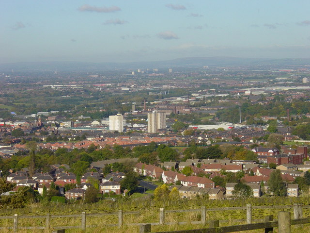
| توضیح | Hyde and Tameside from Werneth Low, in Greater Manchester, England. Hyde Town Hall is on the centre-left of this image. In the background is Dukinfield and Ashton-under-Lyne, both in Tameside. The Pennines are on the horizon. | ||
| تاریخ | |||
| منبع | geograph.org.uk | ||
| پدیدآور | Janine Cook | ||
| اجازهنامه (استفادهٔ مجدد از این پرونده) |
این پرونده با اجازهنامهٔ کریتیو کامانز Attribution-Share Alike 2.0 عمومی منتشر شده است. انتساب: Janine Cook
|
||
| انتساب (required by the license) | Janine Cook / View from Werneth Low on a sunny day / | ||

| مختصات شیء | | محل قرارگیری این نگاره و سایر نگارهها در: نقشهٔ شهری باز |
|---|
_heading:337.00&language=fa)
تاریخچهٔ پرونده
روی تاریخ/زمانها کلیک کنید تا نسخهٔ مربوط به آن هنگام را ببینید.
| تاریخ/زمان | بندانگشتی | ابعاد | کاربر | توضیح | |
|---|---|---|---|---|---|
| کنونی | ۱۱ نوامبر ۲۰۰۸، ساعت ۱۶:۲۵ | | ۶۴۰ در ۴۸۰ (۹۰ کیلوبایت) | Jza84 (بحث | مشارکتها) | {{Information |Description=Hyde and Tameside from Werneth Low, in Greater Manchester, England. Hyde Town Hall is on the centre-left of this image. In the background is Dukinfield and Ashton-under-Lyne, both in Tameside. |Source=[http://www.geograph.org.u |
نمیتوانید این پرونده را رونویسی کنید.
کاربرد پرونده
صفحهٔ زیر از این تصویر استفاده میکند:
کاربرد سراسری پرونده
ویکیهای دیگر زیر از این پرونده استفاده میکنند:
- کاربرد در azb.wikipedia.org
- کاربرد در ceb.wikipedia.org
- کاربرد در cy.wikipedia.org
- کاربرد در es.wikipedia.org
- کاربرد در fa.wikipedia.org
- کاربرد در fr.wikipedia.org
- کاربرد در ga.wikipedia.org
- کاربرد در it.wikipedia.org
- کاربرد در lld.wikipedia.org
- کاربرد در nn.wikipedia.org
- کاربرد در pl.wikipedia.org
- کاربرد در ro.wikipedia.org
- کاربرد در sh.wikipedia.org
- کاربرد در uk.wikivoyage.org
- کاربرد در www.wikidata.org
- کاربرد در zh.wikipedia.org