File:Iceland Mid-Atlantic Ridge map.svg
跳转到导航
跳转到搜索

此SVG文件的PNG预览的大小:376 × 390像素。 其他分辨率:231 × 240像素 | 463 × 480像素 | 740 × 768像素 | 987 × 1,024像素 | 1,974 × 2,048像素。
原始文件 (SVG文件,尺寸为376 × 390像素,文件大小:129 KB)
说明
说明
添加一行文字以描述该文件所表现的内容
摘要
[编辑]| 描述 | |
| 日期 | |
| 来源 | http://pubs.usgs.gov/gip/dynamic/understanding.html |
| 作者 | http://pubs.usgs.gov/gip/dynamic/understanding.html |
| 其他版本 |
|


许可协议
[编辑]
|
|
| 注解 | 该图片含有注解:在维基媒体共享资源上查看注解 |
文件历史
点击某个日期/时间查看对应时刻的文件。
| 日期/时间 | 缩略图 | 大小 | 用户 | 备注 | |
|---|---|---|---|---|---|
| 当前 | 2014年1月10日 (五) 18:48 | | 376 × 390(129 KB) | Amitchell125(留言 | 贡献) | text improved |
| 2010年2月26日 (五) 14:42 |  | 376 × 390(68 KB) | Beao(留言 | 贡献) | Tweak. | |
| 2010年2月26日 (五) 14:40 |  | 376 × 390(68 KB) | Beao(留言 | 贡献) | Tweak. | |
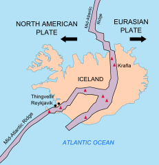
| 2010年2月26日 (五) 14:37 |  | 376 × 390(68 KB) | Beao(留言 | 贡献) | == Summary == {{Information |Description={{en|1=Map showing the Mid-Atlantic Ridge splitting Iceland and separating the North American and Eurasian Plates. The map also shows Reykjavik, the capital of Iceland, the Thingvellir area, and the locations of so |
您不可以覆盖此文件。
文件用途
以下4个页面使用本文件:
全域文件用途
以下其他wiki使用此文件:
- be-tarask.wikipedia.org上的用途
- bn.wikipedia.org上的用途
- ca.wikipedia.org上的用途
- en.wikipedia.org上的用途
- en.wikivoyage.org上的用途
- fi.wikipedia.org上的用途
- hr.wikipedia.org上的用途
- id.wikipedia.org上的用途
- it.wikipedia.org上的用途
- ko.wikipedia.org上的用途
- lb.wikipedia.org上的用途
- nl.wikipedia.org上的用途
- no.wikipedia.org上的用途
- pl.wikipedia.org上的用途
- simple.wikipedia.org上的用途
- sl.wikipedia.org上的用途
- sr.wikipedia.org上的用途
- sv.wikipedia.org上的用途
- tr.wikipedia.org上的用途
- uk.wikipedia.org上的用途
- zh.wikipedia.org上的用途
- zh.wikivoyage.org上的用途