File:Japan location map.svg
跳转到导航
跳转到搜索

此SVG文件的PNG预览的大小:582 × 580像素。 其他分辨率:241 × 240像素 | 482 × 480像素 | 771 × 768像素 | 1,028 × 1,024像素 | 2,055 × 2,048像素。
原始文件 (SVG文件,尺寸为582 × 580像素,文件大小:707 KB)
说明
说明
添加一行文字以描述该文件所表现的内容
摘要
[编辑]| 描述 |
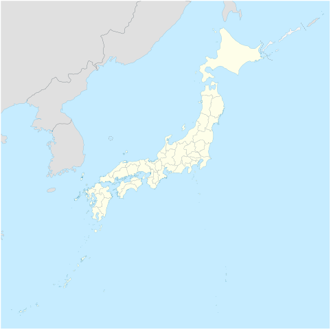
Deutsch: Postionskarte von Japan
Quadratische Plattkarte. Geographische Begrenzung der Karte:
English: Location map of Japan
Equirectangular projection. Geographic limits of the map:
|
||
| 日期 | |||
| 来源 | own work, using Image:Japan_admin_levels.svg | ||
| 作者 | Maximilian Dörrbecker (Chumwa) | ||
| 授权 (二次使用本文件) |
我,本作品著作权人,特此采用以下许可协议发表本作品:
本文件采用知识共享署名-相同方式共享 3.0 未本地化版本许可协议授权。
您可以选择您需要的许可协议。 |
||
| 其他版本 |
此文件衍生的作品: National Treasures of Japan (archaeological materials).png
|


.png)

|
|
文件历史
点击某个日期/时间查看对应时刻的文件。
| 日期/时间 | 缩略图 | 大小 | 用户 | 备注 | |
|---|---|---|---|---|---|
| 当前 | 2020年11月14日 (六) 05:18 | | 582 × 580(707 KB) | AichiWikiFixer(留言 | 贡献) | Reverted to version as of 16:25, 5 April 2020 (UTC) |
| 2020年11月14日 (六) 05:18 |  | 413 × 373(980 KB) | AichiWikiFixer(留言 | 贡献) | Fix borders. | |
| 2020年4月5日 (日) 16:25 |  | 582 × 580(707 KB) | NordNordWest(留言 | 贡献) | Reverted to version as of 10:32, 21 February 2013 (UTC); no discussion about this change; in this set of maps disputed areas are always shown in light grey | |
| 2020年4月5日 (日) 14:25 |  | 582 × 580(726 KB) | Туча(留言 | 贡献) | Итуруп и Кунашир серым цветом | |
| 2013年2月21日 (四) 10:32 |  | 582 × 580(707 KB) | NordNordWest(留言 | 贡献) | Reverted to version as of 13:56, 30 October 2010; no need to revert, no discussion for this | |
| 2013年2月21日 (四) 09:17 |  | 582 × 580(1.21 MB) | Pauk(留言 | 贡献) | Reverted to version as of 01:23, 17 September 2010 | |
| 2010年10月30日 (六) 13:56 |  | 582 × 580(707 KB) | NordNordWest(留言 | 贡献) | Liancourt Rocks boundary | |
| 2010年9月17日 (五) 01:23 |  | 582 × 580(1.21 MB) | Dinamik(留言 | 贡献) | medium color for disputed territories | |
| 2010年3月21日 (日) 11:40 |  | 582 × 580(1.18 MB) | Chumwa(留言 | 贡献) | Präfekturgrenzen bereinigt | |
| 2010年3月20日 (六) 09:55 |  | 582 × 580(1.37 MB) | Chumwa(留言 | 贡献) | einige Inseln ergänzt und diverse Lagekorrekturen durchgeführt |
您不可以覆盖此文件。
文件用途
以下21个页面使用本文件:
- User:Chumwa/Gallery
- User:Nahabino/sandbox
- User:SpinnerLaserz/Flags/Flags of France/Japan
- User:SpinnerLaserzthe2nd/Flags/Flags of Japan/Japan
- File:J-ALERT Image3-en.svg
- File:J-ALERT Image3.svg
- File:Japan bluemarble location map with side map of the Ryukyu Islands.jpg
- File:Japan location map-topographic.png
- File:Japan location map with side map of the Ryukyu Islands.svg
- File:Japan location map zoom south.svg
- File:Japan location map zoom west.svg
- File:Japan natural location map with side map of the Ryukyu Islands.jpg
- File:Japan relief location map.jpg
- File:Japan relief location map with side map of the Ryukyu Islands.jpg
- File:Japanese Macaque area.svg
- File:National Treasures of Japan (archaeological materials).png
- File:National Treasures of Japan (crafts- others).png
- File:National Treasures of Japan (crafts-swords).png
- File:National Treasures of Japan (sculptures).png
- File:National Treasures of Japan (writings- others).png
- File:Russian-occupied territories (extended).svg
.png)
.png)
.png)
.png)
.svg)
全域文件用途
以下其他wiki使用此文件:
- ba.wikipedia.org上的用途
- bcl.wikipedia.org上的用途
- bg.wikinews.org上的用途
- crh.wikipedia.org上的用途
- da.wikipedia.org上的用途
- de.wikipedia.org上的用途
- en.wikipedia.org上的用途
- Iwo Jima
- Cities designated by government ordinance of Japan
- Ogasawara, Tokyo
- Chichijima
- Hahajima
- Senhata, Akita
- Hiranai
- Hachijō-jima
- Yonaguni Monument
- North Iwo Jima
- South Iwo Jima
- Fukutoku-Okanoba
- Nishinoshima (Ogasawara)
- 2013–14 FIS Ski Jumping World Cup
- Wikipedia talk:WikiProject Geographical coordinates/Archive 29
- 2020 Summer Olympics torch relay
- Module:Location map/data/Japan complete
- Module:Location map/data/Japan complete/doc
- 2015 Ogasawara earthquake
- Chibusa Dam
- Nakōdo-jima
- Naval Base Iwo Jima
- User:Turbo Slayer 2021
- User:Mr J 2023
- 1931 Empress of Canada stabbings
- List of mass stabbing incidents (before 2010)
- eo.wikipedia.org上的用途
查看此文件的更多全域用途。