File:Japanese Empire2.png
跳转到导航
跳转到搜索
本预览的尺寸:515 × 599像素。 其他分辨率:206 × 240像素 | 412 × 480像素 | 660 × 768像素 | 1,032 × 1,201像素。
原始文件 (1,032 × 1,201像素,文件大小:927 KB,MIME类型:image/png)
说明
说明
添加一行文字以描述该文件所表现的内容

|
此military map图片可使用矢量图形重新创建为SVG文件。这具有很多好处;更多信息请参见共享资源:待清理媒体。如果存在此图片的SVG格式,请将其上传,然后将此模板替换为
{{vector version available|新图片名称}}。
建议您将SVG命名为“Japanese Empire2.svg”,这样在使用Vector version available(或Vva)模板时就不需要填写新图片名称参数。 |
摘要
[编辑]| 描述 |
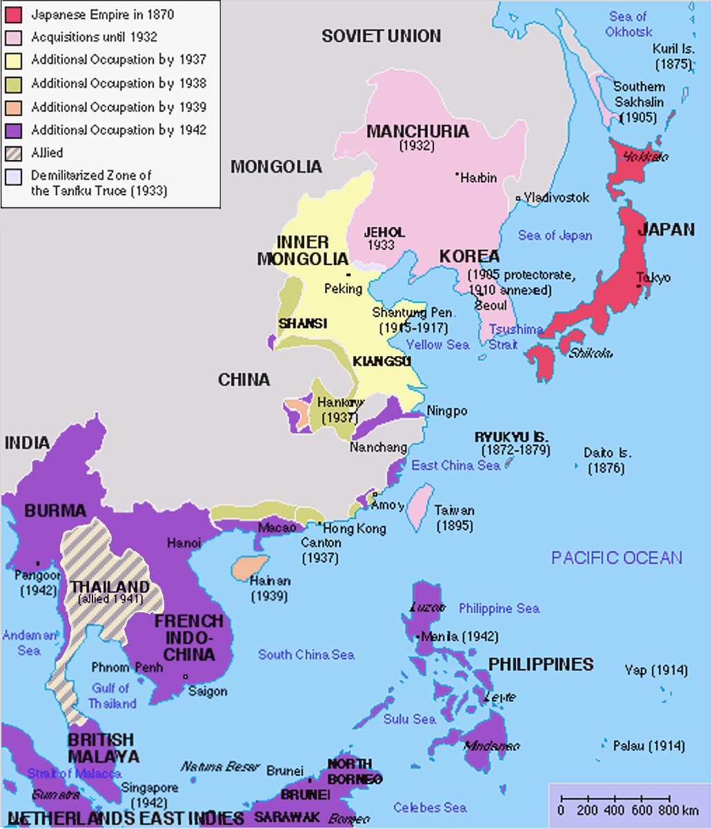
English: Original map was created by Kokiri, based in part on File:BlankMap-World.png. Subsequent modifications to colors performed by Huhsunqu. Additional corrections (fixed Ryukyu Islands, Sichuan, grammar in table) by Markalexander100. |
||||||||
| 日期 | (original upload date at English Wikipedia) | ||||||||
| 来源 |
本檔案衍生自: Japanese Empire.png |
||||||||
| 作者 | 英语维基百科的Kokiri, modifications by Huhsunqu and Markalexander100. | ||||||||
| 授权 (二次使用本文件) |
|
||||||||
| 其他版本 |
此文件衍生的作品: |

.png)
原始上传日志
[编辑]
The original upload log was here. The usernames refer to the English Wikipedia. Not to be confused with File:Japanese empire.png.
04:00, 6 October 2005 . . Huhsunqu (talk | contribs | block) 508 × 591 (44,305 bytes)02:42, 21 August 2004 . . Nanshu (talk | contribs | block) 508 × 591 (45,178 bytes)09:38, 18 August 2004 . . Kokiri (talk | contribs | block) 508 × 591 (46,867 bytes) (map of the Japanese Empire, drawn myself)
文件历史
点击某个日期/时间查看对应时刻的文件。
| 日期/时间 | 缩略图 | 大小 | 用户 | 备注 | |
|---|---|---|---|---|---|
| 当前 | 2023年3月3日 (五) 12:26 | | 1,032 × 1,201(927 KB) | Hohum(留言 | 贡献) | Brighten |
| 2023年3月3日 (五) 12:24 |  | 1,032 × 1,201(944 KB) | Hohum(留言 | 贡献) | less garish colours | |
| 2023年1月10日 (二) 03:53 |  | 1,032 × 1,201(1,020 KB) | Artanisen(留言 | 贡献) | Added allied color. Thailand was in a coerced alliance (1941) thus part of the empire | |
| 2022年6月22日 (三) 06:20 |  | 1,032 × 1,201(683 KB) | Crab2814(留言 | 贡献) | Removed Tongking- France gave Japan military access to that region in 1940, not an occupational right. Fixed Sakhalin and Hainan. Removed Thailand, which was allied not occupied by Japan. | |
| 2020年8月3日 (一) 11:58 |  | 1,437 × 1,201(1.8 MB) | Artanisen(留言 | 贡献) | Bigger size and sharper version of the same map. The rest is the same. | |
| 2007年7月5日 (四) 11:47 |  | 707 × 591(32 KB) | Mahahahaneapneap(留言 | 贡献) | pngcrushed | |
| 2007年5月27日 (日) 01:31 |  | 707 × 591(48 KB) | Gryffindor(留言 | 贡献) | {{svg}} {{GFDL}} Modified version of Image:Japanese_Empire.png. Fixed Ryukyu Islands, Sichuan, grammar in table. Category:Maps of the history of Japan Category:Maps of the history of Korea Category:Maps of the history of Vietnam [[Categ | |
| 2007年2月27日 (二) 15:13 |  | 508 × 591(36 KB) | Cristan(留言 | 贡献) | Optimized using PNGOUT | |
| 2005年12月22日 (四) 11:24 |  | 508 × 591(47 KB) | Markalexander100(留言 | 贡献) | {{GFDL}} Modified version of Image:Japanese_Empire.png. Fixed Ryukyu Islands, Sichuan, grammar in table. |
您不可以覆盖此文件。
文件用途
以下23个页面使用本文件:
- Atlas of Brunei
- Atlas of Cambodia
- Atlas of Indonesia
- Atlas of Japan
- Atlas of Laos
- Atlas of Malaysia
- Atlas of Myanmar
- Atlas of Singapore
- Atlas of Taiwan
- Atlas of Thailand
- Atlas of Vietnam
- Atlas of World War II
- Atlas of colonialism
- Atlas of the People's Republic of China
- User:Chumwa/OgreBot/Transport Maps/2020 August 1-10
- User:Chumwa/OgreBot/Transport Maps/2022 June 21-30
- User:Chumwa/OgreBot/Travel and communication maps/2020 August 1-10
- User:Chumwa/OgreBot/Travel and communication maps/2022 June 21-30
- User:Magog the Ogre/Maps of conflicts/2020 August
- User:Magog the Ogre/Maps of conflicts/2022 June
- User:Magog the Ogre/Maps of conflicts/2023 January
- User:Magog the Ogre/Maps of conflicts/2023 March
- File:Império Japonês (1870-1942).png
全域文件用途
以下其他wiki使用此文件:
- af.wikipedia.org上的用途
- ar.wikipedia.org上的用途
- bn.wikipedia.org上的用途
- ca.wikipedia.org上的用途
- cs.wikipedia.org上的用途
- de.wikipedia.org上的用途
- en.wikipedia.org上的用途
- eu.wikipedia.org上的用途
- fa.wikipedia.org上的用途
- fi.wikipedia.org上的用途
- fr.wikipedia.org上的用途
- gl.wikipedia.org上的用途
- hak.wikipedia.org上的用途
- he.wikipedia.org上的用途
- hy.wikipedia.org上的用途
- it.wikipedia.org上的用途
- ja.wikipedia.org上的用途
- min.wikipedia.org上的用途
- mk.wikipedia.org上的用途
- ms.wikipedia.org上的用途
- nl.wikipedia.org上的用途
- oc.wikipedia.org上的用途
- pam.wikipedia.org上的用途
- pt.wikipedia.org上的用途
- ro.wikipedia.org上的用途
查看此文件的更多全域用途。
元数据
分类:
- Empire of Vietnam in 1945
- Maps of the Empire of Japan
- Maps of the history of Korea
- Maps of the history of Vietnam
- Maps of the history of Laos
- Maps of the history of Cambodia
- Maps of the history of the Philippines
- Maps of the Republic of China (1912–1949)
- Maps of the history of Indonesia
- Maps of British Malaya
- Maps of Burma during World War II
- Maps of the history of Taiwan
- Maps of the history of Thailand