File:Jerusalem sketch plan of places of interest (FL165906165 0953816).jpg

Original file (2,066 × 3,076 pixels, file size: 3.62 MB, MIME type: image/jpeg)
Captions
Captions
Summary
[edit]| Jerusalem sketch plan of places of interest
( |
||||||||||||||||||||||||
|---|---|---|---|---|---|---|---|---|---|---|---|---|---|---|---|---|---|---|---|---|---|---|---|---|
| Title |
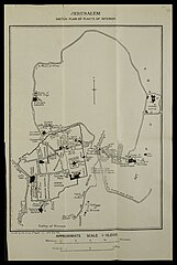
Jerusalem sketch plan of places of interest |
|||||||||||||||||||||||
| Publisher |
The Survey of Egypt |
|||||||||||||||||||||||
| Description |
Jerusalem sketch plan of places of interest.. |
|||||||||||||||||||||||
| Language | English | |||||||||||||||||||||||
| Publication date | 1919 | |||||||||||||||||||||||
| Medium | 1 sheet ; | |||||||||||||||||||||||
| Dimensions | height: 29 cm (11.4 in); width: 19 cm (7.4 in) | |||||||||||||||||||||||
| Collection |
|
|||||||||||||||||||||||
| Current location |
|
|||||||||||||||||||||||
| Place of publication | Giza | |||||||||||||||||||||||
| search Merhav catalog | Giza | |||||||||||||||||||||||
| Notes | Includes location of Military Governor, Modern road to Bethany and Jericho, Turkish barrack yard.; In: Payne, Augustus. Jerusalem, the city of the great king [a soldier's guide to the holy places] 2010 B 7625. At the end of the book. | |||||||||||||||||||||||
| scale | 1:15,000 cm | |||||||||||||||||||||||
| IE PID | IE165906163 | |||||||||||||||||||||||
| Rosetta filename | FL165906165 | |||||||||||||||||||||||
| NNL item ID (P3959) | 997009538162205171 | |||||||||||||||||||||||
| search Merhav catalog | English | |||||||||||||||||||||||
| search Merhav catalog | The Survey of Egypt | |||||||||||||||||||||||
| Source/Photographer |
|
|||||||||||||||||||||||
| Other versions | ||||||||||||||||||||||||
| Jpg / Tif version |
|
|||||||||||||||||||||||

.jpg)

.jpg&action=edit§ion=1)
Licensing
[edit].jpg&action=edit§ion=2)
The copyright of this image has expired in the European Union because it was published more than 70 years ago without a public claim of authorship (anonymous or pseudonymous), and no subsequent claim of authorship was made in the 70 years following its first publication.
|
 | |
To use this template, the image must meet both of the following two conditions:
Images that lack either of these two conditions should not use this template. Reasonable evidence must be presented that the author's name (e.g., the original photographer, portrait painter) was not published with a claim of copyright in conjunction with the image within 70 years of its original publication. Works which had not entered Public Domain in their country in 1996 that were uploaded before 1 March 2012 should be marked additionally with {{Not-PD-US-URAA}}. Note: In some countries anonymous works are copyrighted until 70 years after the death of the author if the author's identity became public in any way during the original term. In Germany this applies to certain works published before July 1, 1995; see Übergangsrecht.
|
File history
Click on a date/time to view the file as it appeared at that time.
| Date/Time | Thumbnail | Dimensions | User | Comment | |
|---|---|---|---|---|---|
| current | 07:28, 12 August 2023 | | 2,066 × 3,076 (3.62 MB) | Geagea (talk | contribs) | pattypan 22.03 |
You cannot overwrite this file.
File usage on Commons
The following page uses this file:
.jpg&oldid=863049903)