File:Karte Deutschland.png
Aller à la navigation
Aller à la recherche
Pas de plus haute résolution disponible.
Karte_Deutschland.png (188 × 235 pixels, taille du fichier : 2 kio, type MIME : image/png)
Légendes
Légendes
Ajoutez en une ligne la description de ce que représente ce fichier
| Description |
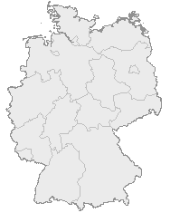
English: Map of Germany with the borders of the 16 federal states.
Deutsch: Karte von Deutschland mit den Grenzen der 16 Bundesländer. |
| Date | Date inconnue |
| Source | OpenGeoDB |
| Auteur | NN/OpenGeoDB |
| Autorisation (Réutilisation de ce fichier) |
GFDL |
This image was generated with OpenGeoDB. The information there is placed in the public domain, images generated from OpenGeoDB are derivative works without passing the threshold of creativity, they are therefore also public domain.
| Ce document n'est pas soumis au droit d’auteur ( copyright ) et est donc dans le domaine public, car il est composé exclusivement d’informations qui sont des propriétés communes et ne contient aucune modification qui en ferait une œuvre originale.
|

|
Une version vectorielle de cette image existe, dans le format « SVG ». Si elle n’est pas inférieure, elle devrait être utilisée à la place de la présente version pour des affichages en plus grandes dimensions ou nécessitant une meilleure résolution.
File:Karte Deutschland.png → File:Germany location map.svg
Pour plus d’informations sur les images vectorielles, consultez la page de transition de Commons vers le format SVG. Voir aussi les informations à propos de la manière dont le logiciel MediaWiki gère les images au format SVG. |
 |
Historique du fichier
Cliquer sur une date et heure pour voir le fichier tel qu'il était à ce moment-là.
| Date et heure | Vignette | Dimensions | Utilisateur | Commentaire | |
|---|---|---|---|---|---|
| actuel | 8 janvier 2008 à 18:46 | | 188 × 235 (2 kio) | Evilboy (d | contributions) | Reverted to version as of 20:35, 14 March 2007 |
| 14 mars 2007 à 20:35 |  | 188 × 235 (2 kio) | Tene~commonswiki (d | contributions) | Optimised (0) | |
| 9 février 2007 à 11:28 |  | 188 × 235 (2 kio) | TMg (d | contributions) | Contrast slightly improved without loosing precision | |
| 31 janvier 2007 à 19:04 |  | 188 × 235 (2 kio) | Leit (d | contributions) | Auf eine alte Version zurückgesetzt | |
| 31 janvier 2007 à 18:17 |  | 188 × 235 (8 kio) | Der Eberswalder (d | contributions) | ||
| 31 janvier 2007 à 12:29 |  | 188 × 235 (2 kio) | Rauenstein (d | contributions) | Auf eine alte Version zurückgesetzt | |
| 31 janvier 2007 à 11:04 |  | 188 × 235 (8 kio) | Der Eberswalder (d | contributions) | now white color outside the borders | |
| 31 janvier 2007 à 10:31 |  | 188 × 235 (2 kio) | Siebrand (d | contributions) | Eerdere versie hersteld | |
| 31 janvier 2007 à 06:31 |  | 188 × 235 (9 kio) | Der Eberswalder (d | contributions) | better viewable | |
| 27 août 2006 à 15:48 |  | 188 × 235 (2 kio) | TMg (d | contributions) | Slightly error corrected version, based on Image:Karte stralsund in deutschland-test.png by de:Benutzer:Rauenstein |
Vous ne pouvez pas remplacer ce fichier.
Utilisations locales du fichier
Les 8 pages suivantes utilisent ce fichier :
Utilisations du fichier sur d’autres wikis
Les autres wikis suivants utilisent ce fichier :
- Utilisation sur ceb.wikipedia.org
- Utilisation sur da.wikipedia.org
- Utilisation sur de.wikipedia.org
- Utilisation sur nds.wikipedia.org
- Landkreis Emsland
- Landkreis Rodenborg (Wümm)
- Landkreis Stood
- Landkreis Heidkreis
- Landkreis Vechte
- Landkreis Veern
- Kreis Noordfreesland
- Landkreis Cuxhoben
- Landkreis Oosterholt
- Landkreis Horborg
- Landkreis Lümborg
- Kreis Pinnbarg
- Landkreis Ollnborg
- Kreis Steenborg
- Landkreis Weißenburg-Gunzenhausen
- Landkreis Würzburg
- Landkreis Wunsiedel im Fichtelgebirge
- Landkreis Weilheim-Schongau
- Landkreis Unterallgäu
- Landkreis Traunstein
- Landkreis Tirschenreuth
- Landkreis Straubing-Bogen
- Landkreis Starnberg
- Landkreis Schweinfurt
- Landkreis Schwandorf
- Landkreis Rottal-Inn
- Landkreis Roth
- Landkreis Rosenheim
- Landkreis Rhön-Grabfeld
- Landkreis Paane
- Landkreis Wulfenbüttel
- Landkreis Groafschup Bentem
- Landkreis Hameln-Purmunt
- Landkreis Aichach-Friedberg
- Landkreis Altötting
- Landkreis Amberg-Sulzbach
- Landkreis Schaumborg
- Landkreis Ülzen
- Landraodsamt Stemmert
- Utilisation sur pms.wikipedia.org
Voir davantage sur l’utilisation globale de ce fichier.