File:Keystone-pipeline-route.svg
Jump to navigation
Jump to search

Size of this PNG preview of this SVG file: 449 × 599 pixels. Other resolutions: 180 × 240 pixels | 360 × 480 pixels | 576 × 768 pixels | 767 × 1,024 pixels | 1,535 × 2,048 pixels | 512 × 683 pixels.
Original file (SVG file, nominally 512 × 683 pixels, file size: 220 KB)
Captions
Captions
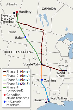
Operational and proposed route of the Keystone Pipeline System
Summary
[edit]| Description |
Français : Tracé opérationnel et propositions de prolongements de l'oléoduc Keystone. |
|||
| Date | ||||
| Source |
|
|||
| Author | cmglee, Meclee, Flappiefh, Lokal_Profil et al. | |||
| Other versions |
File:Keystone-pipeline-route.svg has 1 translations.
|
|||
| SVG development | This W3C-invalid map was created with an unknown SVG tool. This map is translated using SVG switch elements: all translations are stored in the same file. |


Licensing
[edit]
This file is licensed under the Creative Commons Attribution-Share Alike 4.0 International license.
- You are free:
- to share – to copy, distribute and transmit the work
- to remix – to adapt the work
- Under the following conditions:
- attribution – You must give appropriate credit, provide a link to the license, and indicate if changes were made. You may do so in any reasonable manner, but not in any way that suggests the licensor endorses you or your use.
- share alike – If you remix, transform, or build upon the material, you must distribute your contributions under the same or compatible license as the original.
File history
Click on a date/time to view the file as it appeared at that time.
| Date/Time | Thumbnail | Dimensions | User | Comment | |
|---|---|---|---|---|---|
| current | 03:36, 12 November 2018 | | 512 × 683 (220 KB) | Cmglee (talk | contribs) | Make text more legible. |
| 03:31, 12 November 2018 |  | 512 × 683 (220 KB) | Cmglee (talk | contribs) | Make background cyan. | |
| 03:05, 12 November 2018 |  | 512 × 683 (220 KB) | Cmglee (talk | contribs) | Add "XL" and fix text. | |
| 21:14, 10 November 2018 |  | 512 × 683 (220 KB) | Cmglee (talk | contribs) | User created page with UploadWizard |
You cannot overwrite this file.
File usage on Commons
The following 3 pages use this file:
File usage on other wikis
The following other wikis use this file:
- Usage on de.wikipedia.org
- Usage on en.wikipedia.org
- Usage on eo.wikipedia.org
- Usage on es.wikipedia.org
- Usage on fr.wikipedia.org
- Usage on he.wikipedia.org
- Usage on ja.wikipedia.org
- Usage on oc.wikipedia.org
- Usage on simple.wikipedia.org
- Usage on zh.wikipedia.org