File:London Transport bus DMS1624 Daimler Fleetline MCW THM 624M Route 166A in Chipstead, Surrey 12 June 1983.jpg
Jump to navigation
Jump to search
No higher resolution available.
London_Transport_bus_DMS1624_Daimler_Fleetline_MCW_THM_624M_Route_166A_in_Chipstead,_Surrey_12_June_1983.jpg (640 × 502 pixels, file size: 87 KB, MIME type: image/jpeg)
Captions
Captions
Add a one-line explanation of what this file represents
Summary
[edit]
| Description |
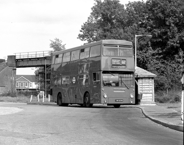
English: Chipstead Valley bus terminus. For many years, Route 166 terminated here, outside the Mid Day Sun public house (behind the photographer). As this photograph was taken on a Sunday, the route number shown by the bus is 166A, because on Sundays the other end of the route was at a different place from the usual Monday to Saturday working. In the background here is seen the bridge carrying the Tattenham Corner branch railway over the B2032 road. In the last few years, route 166 has been altered and now runs through to Banstead or Epsom; it is now worked with single-deckers. However, the buses still pull in to this old off-road terminal point in both directions. |
| Date | Taken on 12 June 1983 |
| Source | From geograph.org.uk |
| Author | Dr Neil Clifton |
| Permission (Reusing this file) |
Creative Commons Attribution Share-alike license 2.0 |
| Camera location | | View this and other nearby images on: OpenStreetMap |
|---|
Licensing
[edit]

|
This image was taken from the Geograph project collection. See this photograph's page on the Geograph website for the photographer's contact details. The copyright on this image is owned by Dr Neil Clifton and is licensed for reuse under the Creative Commons Attribution-ShareAlike 2.0 license.
|
This file is licensed under the Creative Commons Attribution-Share Alike 2.0 Generic license.
Attribution: Dr Neil Clifton
- You are free:
- to share – to copy, distribute and transmit the work
- to remix – to adapt the work
- Under the following conditions:
- attribution – You must give appropriate credit, provide a link to the license, and indicate if changes were made. You may do so in any reasonable manner, but not in any way that suggests the licensor endorses you or your use.
- share alike – If you remix, transform, or build upon the material, you must distribute your contributions under the same or compatible license as the original.
File history
Click on a date/time to view the file as it appeared at that time.
| Date/Time | Thumbnail | Dimensions | User | Comment | |
|---|---|---|---|---|---|
| current | 18:28, 1 June 2009 | | 640 × 502 (87 KB) | Ultra7 (talk | contribs) | {{Information |Description=see file name {{cc-by-sa-2.0}} |Source=geograph.org.uk see here for exact file |Date=see file name |Author=geograph photographer, see source file |Permission= |other_versions= }} |
You cannot overwrite this file.
File usage on Commons
The following page uses this file:
File usage on other wikis
The following other wikis use this file:
- Usage on www.wikidata.org