File:Madras 1822.jpg
Jump to navigation
Jump to search

Size of this preview: 800 × 532 pixels. Other resolutions: 320 × 213 pixels | 640 × 425 pixels | 1,024 × 680 pixels | 1,280 × 851 pixels | 2,560 × 1,701 pixels | 17,456 × 11,600 pixels.
Original file (17,456 × 11,600 pixels, file size: 107.7 MB, MIME type: image/jpeg)
Captions
Captions
Add a one-line explanation of what this file represents
| Warning | The original file is very high-resolution. It might not load properly or could cause your browser to freeze when opened at full size. |
|---|
| Description |
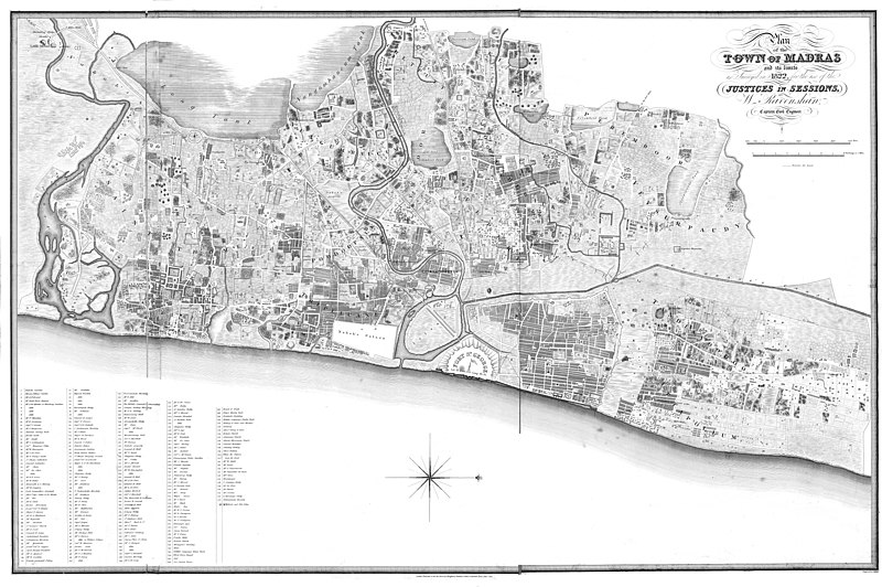
Plan of the town of Madras and its limits, as surveyed in 1822 for the use of the Justices in Sessions / by W. Ravenshaw Captain Civil Engineer. |
|||||||||
| Date | ||||||||||
| Source | https://gallica.bnf.fr/ark:/12148/btv1b530986164 | |||||||||
| Creator |
Engraved by J. Walker |
|||||||||
| Permission (Reusing this file) |
|
|||||||||
| Geotemporal data | ||||||||||
| Bounding box |
|
|||||||||
| Georeferencing | ||||||||||
File history
Click on a date/time to view the file as it appeared at that time.
| Date/Time | Thumbnail | Dimensions | User | Comment | |
|---|---|---|---|---|---|
| current | 10:01, 26 January 2021 | | 17,456 × 11,600 (107.7 MB) | Shyamal (talk | contribs) | c:User:Rillke/bigChunkedUpload.js: {{Map |Description=Plan of the town of Madras and its limits, as surveyed in 1822 for the use of the Justices in Sessions / by W. Ravenshaw Captain Civil Engineer. |Source=https://gallica.bnf.fr/ark:/12148/btv1b530986164 |Date=1822 |Author=Engraved by J. Walker |Permission={{pd-old-100}} |other_versions= }} |
You cannot overwrite this file.
File usage on Commons
There are no pages that use this file.