File:Map of Assyria.png
Zur Navigation springen
Zur Suche springen
Größe dieser Vorschau: 800 × 550 Pixel. Weitere Auflösungen: 320 × 220 Pixel | 640 × 440 Pixel | 1.024 × 704 Pixel | 1.280 × 880 Pixel | 1.983 × 1.363 Pixel.
Originaldatei (1.983 × 1.363 Pixel, Dateigröße: 160 KB, MIME-Typ: image/png)
Bildtexte
Kurzbeschreibungen
Ergänze eine einzeilige Erklärung, was diese Datei darstellt.
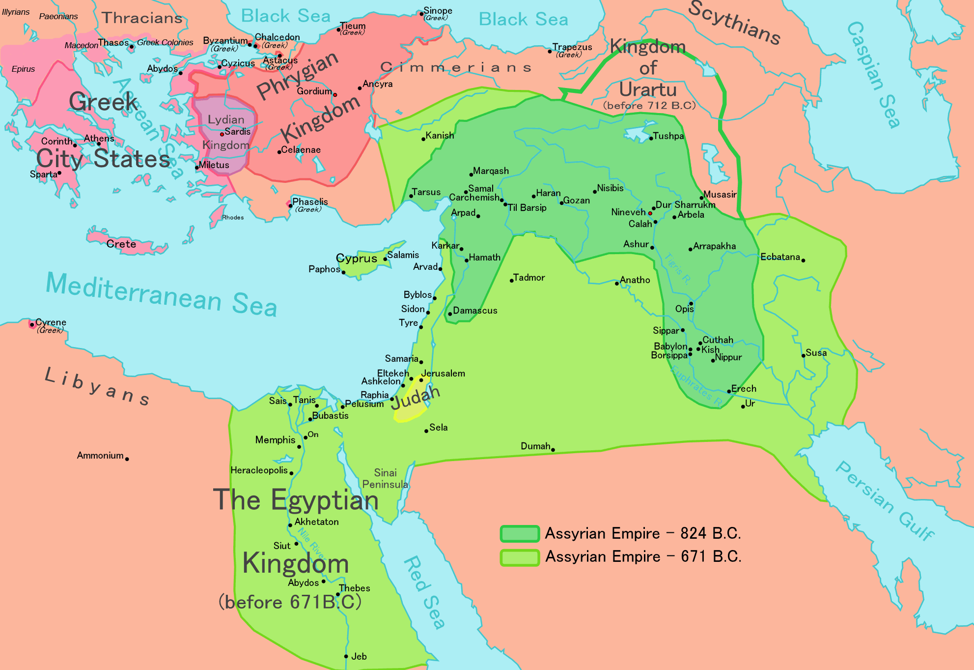
Map of the Assyrian Empire 824 BCE to 671 BCE
| Beschreibung |
[] English: Map of the Assyrian Empire Español: Extensión del Imperio Asirio Polski: Mapa Asyrii w 824 i 671 r. p.n.e. Português: Extensão do Império Assírio العربية : خارطة الإمبراطوريَّة الآشوريَّة. فارسی : نقشه امپراتوری آشور |
|||
| Datum | ||||
| Quelle |
Own work data from
|
|||
| Urheber | Ningyou | |||
| Genehmigung (Weiternutzung dieser Datei) |
|
|||
| Andere Versionen |
[]
|


Dateiversionen
Klicke auf einen Zeitpunkt, um diese Version zu laden.
| Version vom | Vorschaubild | Maße | Benutzer | Kommentar | |
|---|---|---|---|---|---|
| aktuell | 12:32, 24. Mai 2018 | | 1.983 × 1.363 (160 KB) | Capmo (Diskussion | Beiträge) | corrected typos in Trapezus and Hamath |
| 18:33, 12. Sep. 2010 |  | 1.983 × 1.363 (148 KB) | Ras67 (Diskussion | Beiträge) | cropped and squeezed | |
| 00:35, 1. Sep. 2010 |  | 1.985 × 1.365 (161 KB) | Capmo (Diskussion | Beiträge) | typo in word "Aegean"; 256 colors | |
| 21:05, 21. Jan. 2010 |  | 1.985 × 1.365 (645 KB) | Megistias (Diskussion | Beiträge) | Border around map, Details | |
| 14:51, 26. Feb. 2006 |  | 1.985 × 1.365 (640 KB) | Ningyou (Diskussion | Beiträge) | This is a large map of Assyria, made by Ningyou. For translations of this map, contact Ningyou. Category:Assyria |
Du kannst diese Datei nicht überschreiben.
Dateiverwendung
Die folgenden 26 Seiten verwenden diese Datei:
- Atlas of Armenia
- Atlas of Azerbaijan
- Atlas of Cyprus
- Atlas of Egypt
- Atlas of Greece
- Atlas of Iran
- Atlas of Iraq
- Atlas of Israel
- Atlas of Jordan
- Atlas of Kuwait
- Atlas of Lebanon
- Atlas of Northern Cyprus
- Atlas of Palestine
- Atlas of Syria
- Atlas of Turkey
- Maps of the history of the Levant
- File:Map of Assyria-ar.png
- File:Map of Assyria-es.svg
- File:Map of Assyria-pt.svg
- File:Map of Assyria.png
- File:Map of Assyria FA.png
- File:Map of the Assyrian Empire.svg
- File:Mapa Asyrii.png
- File:Territorial organization of the Assyrian Empire in times of Ashurbanipal.svg
- Template:Other versions/Map of Assyria
- Category:Neo-Assyrian Empire
Globale Dateiverwendung
Die nachfolgenden anderen Wikis verwenden diese Datei:
- Verwendung auf af.wikipedia.org
- Verwendung auf als.wikipedia.org
- Verwendung auf am.wikipedia.org
- Verwendung auf an.wikipedia.org
- Verwendung auf arc.wikipedia.org
- Verwendung auf ar.wikipedia.org
- Verwendung auf ast.wikipedia.org
- Verwendung auf azb.wikipedia.org
- Verwendung auf az.wikipedia.org
- Verwendung auf ba.wikipedia.org
- Verwendung auf be.wikipedia.org
- Verwendung auf bg.wikipedia.org
- Verwendung auf bn.wikipedia.org
- Verwendung auf ca.wikipedia.org
- Verwendung auf ckb.wikipedia.org
- Verwendung auf cs.wikipedia.org
- Verwendung auf cv.wikipedia.org
- Verwendung auf cy.wikipedia.org
- Verwendung auf dag.wikipedia.org
- Verwendung auf da.wikipedia.org
- Verwendung auf de.wikipedia.org
- Verwendung auf el.wikipedia.org
Weitere globale Verwendungen dieser Datei anschauen.