File:Map of the city of Albany - drawn by John Bradt Esqr., city supervisor, from the late surveys of Geo. W. Carpenter Esqr., by order of the State Commissioners for the assessment of the Albany NYPL434782.tiff
Jump to navigation
Jump to search

Size of this JPG preview of this TIF file: 800 × 528 pixels. Other resolutions: 320 × 211 pixels | 640 × 422 pixels | 1,024 × 676 pixels | 1,280 × 845 pixels | 2,560 × 1,690 pixels | 7,511 × 4,958 pixels.
Original file (7,511 × 4,958 pixels, file size: 106.55 MB, MIME type: image/tiff)
Captions
Captions
Add a one-line explanation of what this file represents
Summary
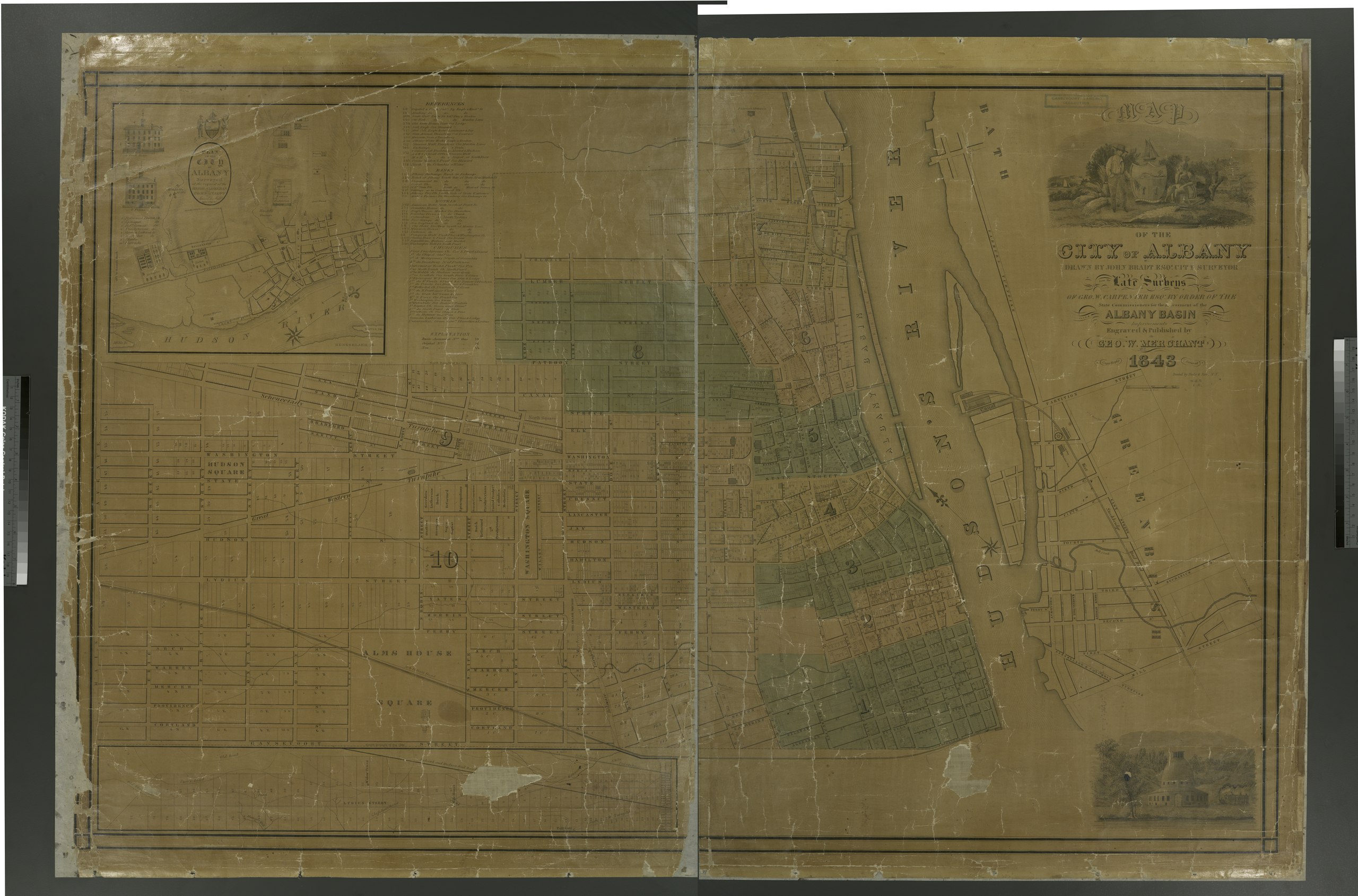
[edit]| Description | Map of the city of Albany / drawn by John Bradt Esqr., city supervisor, from the late surveys of Geo. W. Carpenter Esqr., by order of the State Commissioners for the assessment of the Albany Basin ; engraved ... by Geo. W. Merchant.; Maps of New York City and State / Cities and towns, A-Z | |||||||||||||||||||||||
| Notes | Includes decorative cartouche, ill. Also includes index to buildings, banks, hotels and churches. ''Note 2.'') Inset: A plan of the city of Albany : surveyed at the request of the mayor, aldermen, and commonalty / by Simeon De Witt, 1794. ''Note 3.'') National Endowment for the Humanities Grant for Access to Early Maps of the Middle Atlantic Seaboard. ''Note 4.'') Oriented with north to upper left. ''Note 5.'') Shows wards and block numbers. | |||||||||||||||||||||||
| Item physical description | 1 map on 2 sheets : hand col. ; 72 x 112 cm. sheets 82 x 59 cm. and 82 x 62 cm. | |||||||||||||||||||||||
| Catalogue call number | Map Div. 01-1943 | |||||||||||||||||||||||
| Date | ||||||||||||||||||||||||
| Source |
http://digitalgallery.nypl.org/nypldigital/dgkeysearchdetail.cfm?imageID=1951063
|
|||||||||||||||||||||||
| Author | John -- Cartographer Bradt | |||||||||||||||||||||||
| Permission (Reusing this file) |
From The Lionel Pincus and Princess Firyal Map Division. http://maps.nypl.org
|
|||||||||||||||||||||||
| Location | Stephen A. Schwarzman Building / The Lionel Pincus and Princess Firyal Map Division | |||||||||||||||||||||||
| Digital item published | 2-3-2004; updated 3-25-2011 | |||||||||||||||||||||||
| Digital ID | 434782 | |||||||||||||||||||||||

The making of this file was supported by Wikimedia UK.
To see other files made with the support of Wikimedia UK, please see the category Supported by Wikimedia UK.
|
File history
Click on a date/time to view the file as it appeared at that time.
| Date/Time | Thumbnail | Dimensions | User | Comment | |
|---|---|---|---|---|---|
| current | 22:51, 9 May 2014 |  | 7,511 × 4,958 (106.55 MB) | Fæ (talk | contribs) | GWToolset: Creating mediafile for Fæ. Tranche 4 -12906 @11:45 BST, 9 May 2014 |
You cannot overwrite this file.
File usage on Commons
There are no pages that use this file.