File:Morocco Protectorate.svg
跳转到导航
跳转到搜索

此SVG文件的PNG预览的大小:406 × 388像素。 其他分辨率:251 × 240像素 | 502 × 480像素 | 804 × 768像素 | 1,072 × 1,024像素 | 2,143 × 2,048像素。
原始文件 (SVG文件,尺寸为406 × 388像素,文件大小:815 KB)
说明
说明
添加一行文字以描述该文件所表现的内容
摘要[编辑]
| 描述 |
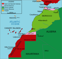
English: Vectorised map about the French and Spanish protectorate on Morocco in 1912 - own work inspired from Jean Sellier, Atlas des peuples d'Afrique, p. 84. Français : Protectorat marocain Español: Protectorado marroquí
A PNG french version is available |
||||||||
| 来源 | Image:Maroc sans cadre.svg | ||||||||
| 作者 | Cradel | ||||||||
| 授权 (二次使用本文件) |
我,本作品著作权人,特此采用以下许可协议发表本作品:
您可以选择您需要的许可协议。 |
||||||||
| 其他版本 |
|
||||||||
| SVG开发 |


文件历史
点击某个日期/时间查看对应时刻的文件。
| 日期/时间 | 缩略图 | 大小 | 用户 | 备注 | |
|---|---|---|---|---|---|
| 当前 | 2020年11月16日 (一) 19:25 | | 406 × 388(815 KB) | Fertejol(留言 | 贡献) | Reverted to version as of 13:49, 4 June 2008 (UTC) The legal international status of Cap Juby zone never changed during the Spanish ocupation (1912-1958). |
| 2010年3月28日 (日) 00:05 |  | 406 × 388(827 KB) | Flad(留言 | 贡献) | Position adjustment. | |
| 2010年3月27日 (六) 23:51 |  | 406 × 388(828 KB) | Flad(留言 | 贡献) | Transform some text in order to show properly. | |
| 2010年3月27日 (六) 23:49 |  | 406 × 388(825 KB) | Flad(留言 | 贡献) | Transform some text in order to show properly. | |
| 2010年3月27日 (六) 23:46 |  | 406 × 388(825 KB) | Flad(留言 | 贡献) | Cap Juby was considered as a part of the spanish colonies. Transform some text to show properly. | |
| 2008年6月4日 (三) 13:49 |  | 406 × 388(815 KB) | Cradel(留言 | 贡献) | more translating Category:Images by Cradel | |
| 2008年6月1日 (日) 19:38 |  | 406 × 388(817 KB) | Cradel(留言 | 贡献) | Cape Juby | |
| 2008年6月1日 (日) 09:01 |  | 406 × 388(821 KB) | Cradel(留言 | 贡献) | {{Information |Description={{en|1=Vectorised map about thefrench and spanish protectorate on marocco In 1912 own work inspired from Jean Sellier, Atlas des peuples d'Afrique,p 84. Protectorat marocain Protectorado maroqui A PNG french version is availabl |
您不可以覆盖此文件。
文件用途
以下8个页面使用本文件:
.png)
.svg)
全域文件用途
以下其他wiki使用此文件:
- ary.wikipedia.org上的用途
- ast.wikipedia.org上的用途
- azb.wikipedia.org上的用途
- be.wikipedia.org上的用途
- cs.wikipedia.org上的用途
- da.wikipedia.org上的用途
- en.wikipedia.org上的用途
- eo.wikipedia.org上的用途
- eu.wikipedia.org上的用途
- fa.wikipedia.org上的用途
- fi.wikipedia.org上的用途
- gl.wikipedia.org上的用途
- he.wikipedia.org上的用途
- hr.wikipedia.org上的用途
- id.wikipedia.org上的用途
- io.wikipedia.org上的用途
- it.wikipedia.org上的用途
- ja.wikipedia.org上的用途
查看本文件的更多全域用途。